See Lansdowne Road railway station, Dublin, on the map
Directions to Lansdowne Road railway station (Dublin) with public transportation
The following transit lines have routes that pass near Lansdowne Road railway station
 Bus:
Bus: - Train:
How to get to Lansdowne Road railway station by bus?
Click on the bus route to see step by step directions with maps, line arrival times and updated time schedules.
How to get to Lansdowne Road railway station by train?
Click on the train route to see step by step directions with maps, line arrival times and updated time schedules.
Bus stations near Lansdowne Road railway station in Dublin
- American Embassy,9 min walk,
Bus lines to Lansdowne Road railway station in Dublin
- S2,Heuston Station,
- 4,O'Connell St,
- 7,Mountjoy Square,
- 7A,Mountjoy Square,
- 7E,Mountjoy Square,
- 120,Ashtown Stn,
- DUBLIN AIRPORT - CHARLESLAND ROAD (SEABORNE VIEW APTS),Zone 2, Stop 3665,
- DUBLIN AIRPORT - KILLINEY (FITZPATRICK CASTLE HOTEL),Zone 2, Stop 3665,
What are the closest stations to Lansdowne Road railway station?
The closest stations to Lansdowne Road railway station are:
- American Embassy is 680 meters away, 9 min walk.
Which bus lines stop near Lansdowne Road railway station?
These bus lines stop near Lansdowne Road railway station: 18, 4, 702, 703.
Which train line stops near Lansdowne Road railway station?
DART
What’s the nearest bus stop to Lansdowne Road railway station in Dublin?
The nearest bus stop to Lansdowne Road railway station in Dublin is American Embassy. It’s a 9 min walk away.
See Lansdowne Road railway station, Dublin, on the map
Public Transit to Lansdowne Road railway station in Dublin
Wondering how to get to Lansdowne Road railway station in Dublin, Ireland? Moovit helps you find the best way to get to Lansdowne Road railway station with step-by-step directions from the nearest public transit station.
Moovit provides free maps and live directions to help you navigate through your city. View schedules, routes, timetables, and find out how long does it take to get to Lansdowne Road railway station in real time.
Looking for the nearest stop or station to Lansdowne Road railway station? Check out this list of stops closest to your destination: American Embassy.
Bus:Train:
Want to see if there’s another route that gets you there at an earlier time? Moovit helps you find alternative routes or times. Get directions from and directions to Lansdowne Road railway station easily from the Moovit App or Website.
We make riding to Lansdowne Road railway station easy, which is why over 1.5 million users, including users in Dublin, trust Moovit as the best app for public transit. You don’t need to download an individual bus app or train app, Moovit is your all-in-one transit app that helps you find the best bus time or train time available.
For information on prices of bus and train, costs and ride fares to Lansdowne Road railway station, please check the Moovit app.
Use the app to navigate to popular places including to the airport, hospital, stadium, grocery store, mall, coffee shop, school, college, and university.
Location: Dublin, Ireland
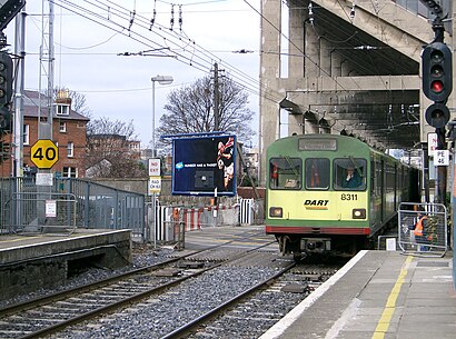
Lansdowne Road railway station (Irish: Stáisiún Bhóthar Lansdúin) is a railway station in Dublin, Ireland. The station serves the Ballsbridge and Upper Baggot Street areas of Dublin 4.Wiki
Attractions near Lansdowne Road railway station
Lansdowne Road,Quench,Stadium Entrance E,Авива Стейдиъм,Στάδιο Αβίβα,אצטדיון אביבה,Staid Aviva,新蘭斯敦路球場,ورزشگاه آویوا,Стадион Авива,Estadio Aviva,ملعب أفيفا,Авива,아비바 스타디움,Stadion Aviva,アビバ・スタジアム,Dublin Southside,57-61 Lansdowne Road,Ipa (Institute Of Public Administration),2 Shelbourne AvenueHow to get to popular attractions in Dublin with public transit
Stephen's Green Shopping Centre, Dublin,Dún Laoghaire Harbour,The Brazen Head, Dublin,Ucd Michael Smurfit Graduate Business School,IKEA, Dubber,Malahide, Malahide,Generator Hostel Dublin, Dublin,Galway, Galway,Connolly Train Station, Dublin,Shankill, Shankill,Dublin Airport (DUB), Airport,Avoca Handweavers, Rathcoole,Phoenix Park Visitors' Centre, Dublin,Dundalk Clarke Railway Station, Dundalk,St. Stephen's Green East, Dublin,Dundrum Luas, Dundrum,The Square Shopping Centre, Tallaght,Vodafone Ireland, Glencullen,Dublin City University (DCU), Dublin,Children's Health Ireland at Crumlin, DublinGet around Dublin by public transit!
Traveling around Dublin has never been so easy. See step by step directions as you travel to any attraction, street or major public transit station. View bus and train schedules, arrival times, service alerts and detailed routes on a map, so you know exactly how to get to anywhere in Dublin.
When traveling to any destination around Dublin use Moovit's Live Directions with Get Off Notifications to know exactly where and how far to walk, how long to wait for your line, and how many stops are left. Moovit will alert you when it's time to get off — no need to constantly re-check whether yours is the next stop.
Wondering how to use public transit in Dublin or how to pay for public transit in Dublin? Moovit public transit app can help you navigate your way with public transit easily, and at minimum cost. It includes public transit fees, ticket prices, and costs. Looking for a map of Dublin public transit lines? Moovit public transit app shows all public transit maps in Dublin with all bus or train routes and stops on an interactive map.
Dublin has 2 transit type(s), including: bus or train, operated by several transit agencies, including Luas, Bus Átha Cliath – Dublin Bus, Bus Éireann, Go-Ahead Ireland, Nitelink, Dublin Bus, Citylink, Kenneally's Bus Service, Aircoach, TFI Local Link Mayo, Irish Rail, Express Bus, JJ/Bernard Kavanagh, Dublin Coach, Kearns Transport and Matthews Coach Hire