How to get to Losbrothersremoval by bus?
Click on the bus route to see step by step directions with maps, line arrival times and updated time schedules.
From Micro Center (Micro Elecronics), Cambridge
77 minFrom Boston Landing Station, Boston
88 minFrom AC Hotel Boston Cambridge, Cambridge
103 minFrom Cambria Hotel Boston Somerville, Somerville
60 minFrom Nahant Beach, Nahant
58 minFrom North Shore Community College Lynn, Lynn
50 minFrom Jordan Hall, Boston
68 minFrom Astrazeneca Hope Lodge, Boston
72 minFrom Hampton Inn & Suites Boston Crosstown Ctr, Boston
62 minFrom 75 / 101 Federal Street, Boston
33 min
How to get to Losbrothersremoval by train?
Click on the train route to see step by step directions with maps, line arrival times and updated time schedules.
How to get to Losbrothersremoval by subway?
Click on the subway route to see step by step directions with maps, line arrival times and updated time schedules.
From Micro Center (Micro Elecronics), Cambridge
84 minFrom Boston Landing Station, Boston
99 minFrom AC Hotel Boston Cambridge, Cambridge
89 minFrom Cambria Hotel Boston Somerville, Somerville
80 minFrom Jordan Hall, Boston
56 minFrom Astrazeneca Hope Lodge, Boston
79 minFrom Hampton Inn & Suites Boston Crosstown Ctr, Boston
70 minFrom 75 / 101 Federal Street, Boston
47 min
Subway station near Losbrothersremoval in Chelsea
- Airport, 1 min walk,VIEW
Bus stops near Losbrothersremoval in Chelsea
Train station near Losbrothersremoval in Chelsea
- Chelsea, 11 min walk,VIEW
Bus lines to Losbrothersremoval in Chelsea
What are the closest stations to Losbrothersremoval?
The closest stations to Losbrothersremoval are:
- Airport is 42 yards away, 1 min walk.
- Broadway @ Cary Ave is 137 yards away, 2 min walk.
- Sixth St @ Poplar St is 279 yards away, 4 min walk.
- Bellingham Square is 313 yards away, 4 min walk.
- Washington Ave @ Heard St is 355 yards away, 5 min walk.
- Chelsea is 877 yards away, 11 min walk.
Which bus lines stop near Losbrothersremoval?
These bus lines stop near Losbrothersremoval: 104, 111, 116, SL3.
Which train line stops near Losbrothersremoval?
NEWBURYPORT/ROCKPORT (#27 | Rockport)
Which subway line stops near Losbrothersremoval?
BLUE LINE (Wonderland)
What’s the nearest subway station to Losbrothersremoval in Chelsea?
The nearest subway station to Losbrothersremoval in Chelsea is Airport. It’s a 1 min walk away.
What’s the nearest train station to Losbrothersremoval in Chelsea?
The nearest train station to Losbrothersremoval in Chelsea is Chelsea. It’s a 11 min walk away.
What’s the nearest bus station to Losbrothersremoval in Chelsea?
The nearest bus station to Losbrothersremoval in Chelsea is Broadway @ Cary Ave. It’s a 2 min walk away.
What time is the first subway to Losbrothersremoval in Chelsea?
The BLUE LINE is the first subway that goes to Losbrothersremoval in Chelsea. It stops nearby at 5:08 AM.
What time is the last subway to Losbrothersremoval in Chelsea?
The BLUE LINE is the last subway that goes to Losbrothersremoval in Chelsea. It stops nearby at 2:03 AM.
What time is the first train to Losbrothersremoval in Chelsea?
The NEWBURYPORT/ROCKPORT is the first train that goes to Losbrothersremoval in Chelsea. It stops nearby at 5:40 AM.
What time is the last train to Losbrothersremoval in Chelsea?
The NEWBURYPORT/ROCKPORT is the last train that goes to Losbrothersremoval in Chelsea. It stops nearby at 12:06 AM.
What time is the first bus to Losbrothersremoval in Chelsea?
The 116 is the first bus that goes to Losbrothersremoval in Chelsea. It stops nearby at 4:34 AM.
What time is the last bus to Losbrothersremoval in Chelsea?
The 111 is the last bus that goes to Losbrothersremoval in Chelsea. It stops nearby at 2:30 AM.
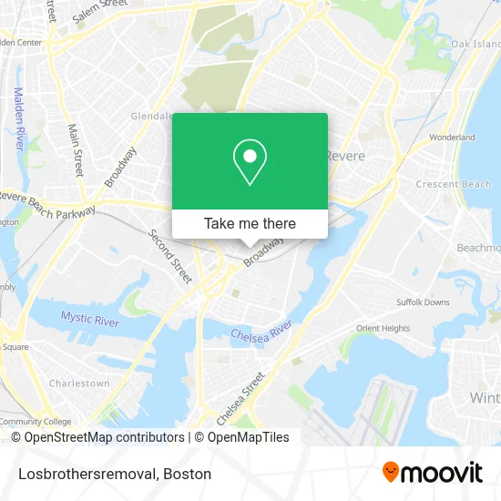
See Losbrothersremoval, Chelsea, on the map
Public Transit to Losbrothersremoval in Chelsea
Wondering how to get to Losbrothersremoval in Chelsea? Moovit helps you find the best way to get to Losbrothersremoval with step-by-step directions from the nearest public transit station.
Moovit provides free maps and live directions to help you navigate through your city. View schedules, routes, timetables, and find out how long does it take to get to Losbrothersremoval in real time.
Looking for the nearest stop or station to Losbrothersremoval? Check out this list of stops closest to your destination: Airport; Broadway @ Cary Ave; Sixth St @ Poplar St; Bellingham Square; Washington Ave @ Heard St; Chelsea.
Bus: 104, 111, 116, SL3, 112, 114.Train: NEWBURYPORT/ROCKPORT.Subway: BLUE LINE.
Want to see if there’s another route that gets you there at an earlier time? Moovit helps you find alternative routes or times. Get directions from and directions to Losbrothersremoval easily from the Moovit App or Website.
We make riding to Losbrothersremoval easy, which is why over 1.7 million users, including users in Chelsea, trust Moovit as the best app for public transit. You don’t need to download an individual bus app or train app, Moovit is your all-in-one transit app that helps you find the best bus time or train time available.
For information on prices of bus, subway and train, costs and ride fares to Losbrothersremoval, please check the Moovit app.
Use the app to navigate to popular places including to the airport, hospital, stadium, grocery store, mall, coffee shop, school, college, and university.
Losbrothersremoval Address: 20 Clark Ave street in Chelsea
- MBTA Bus Route 117,
- Iglesia La Luz De Cristo,
- Palomares Painting,
- Cary Square,
- Chelsea Station,
- Massachusetts Soldiers Home,
- Premier Commercial Real Estate,
- La Chula Restaurant,
- Bellingham Square,
- Leo Brooks Locksmiths,
- Super Mart,
- Spencer Ave Building 113,
- BHCC Shuttle Bus,
- Interport Freight,
- Bachata Rosa Restaurant,
- Veteran Services,
- Chelsea, MA,
- Bunker Hill Community College Chelsea,
- Dollar Tienda,
- Chelsea Discount Stop
Places Near Losbrothersremoval (Chelsea)
- Castle Island, Boston,
- House Of Blues, Boston,
- Leader Bank Pavilion (Leader Bank Pavillion), Boston,
- Mgm Music Hall, Boston,
- Seaport District, Boston,
- Boston Common, Boston,
- Museum Of Science, Boston,
- Prudential Center, Boston,
- North End, Boston,
- Quincy Market, Boston,
- Isabella Stewart Gardner Museum, Boston,
- Faneuil Hall, Boston,
- Boston Medical Center, Boston,
- Wilbur Theatre, Boston,
- Boston Convention & Exhibition Center, Boston,
- Massachusetts General Hospital, Boston,
- Cheers, Boston,
- Wang Theater, Boston,
- Boston Children's Hospital, Boston,
- Td Garden, Boston
How to get to popular places in Boston with public transit
Get around Chelsea by public transit!
Traveling around Chelsea has never been so easy. See step by step directions as you travel to any attraction, street or major public transit station. View bus and train schedules, arrival times, service alerts and detailed routes on a map, so you know exactly how to get to anywhere in Chelsea.
When traveling to any destination around Chelsea use Moovit's Live Directions with Get Off Notifications to know exactly where and how far to walk, how long to wait for your line, and how many stops are left. Moovit will alert you when it's time to get off — no need to constantly re-check whether yours is the next stop.
Wondering how to use public transit in Chelsea or how to pay for public transit in Chelsea? Moovit public transit app can help you navigate your way with public transit easily, and at minimum cost. It includes public transit fees, ticket prices, and costs. Looking for a map of Chelsea public transit lines? Moovit public transit app shows all public transit maps in Chelsea with all Bus, Train, Subway and Ferry routes and stops on an interactive map.
Boston has 4 transit type(s), including: Bus, Train, Subway and Ferry, operated by several transit agencies, including MBTA, Southeastern Regional Transit Authority, MetroWest Regional Transit Authority, Rhode Island Public Transit Authority, WRTA, Lowell Regional Transit Authority, Merrimack Valley Transit, Montachusett Regional Transit Authority, Cape Cod Regional Transit Authority, Brockton Area Transit Authority, Martha's Vineyard Transit Authority, the WAVE - Nantucket Regional Transit Authority, GATRA, Cape Ann Transportation Authority and Massport