
How to get to MBK in ปทุมวัน by Bus, Train, Metro or Ferry?

See MBK, ปทุมวัน, on the map

Directions to MBK (ปทุมวัน) with public transportation

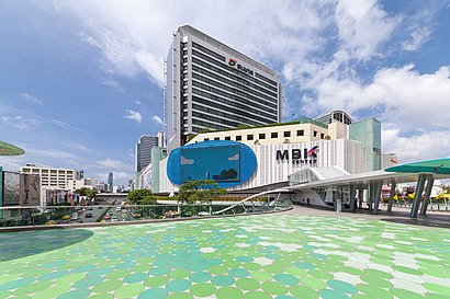
The following transit lines have routes that pass near MBK

  • MetroMetro:
  • BusBus:
  • FerryFerry:
  • TrainTrain:

How to get to MBK by Bus?

Click on the Bus route to see step by step directions with maps, line arrival times and updated time schedules.

How to get to MBK by Train?

Click on the Train route to see step by step directions with maps, line arrival times and updated time schedules.

How to get to MBK by Metro?

Click on the Metro route to see step by step directions with maps, line arrival times and updated time schedules.

How to get to MBK by Ferry?

Click on the Ferry route to see step by step directions with maps, line arrival times and updated time schedules.

Bus stations near MBK in ปทุมวัน

  • สนามกีฬาแห่งชาติ;National Stadium,4 min walk,
  • สนามกีฬาแห่งชาติ National Stadium,4 min walk,
  • โอสถศาลา;Osotsala,4 min walk,
  • ตรงข้ามมาบุญครอง Opp Mbk Center,4 min walk,
  • Bts สนามกีฬา (สิ้นสุด);Bts National Stadium (End),4 min walk,
  • จุฬาฯ (หอพักนิสิต);Opposite Triam Udom Suksa School,6 min walk,

SkyTrain stations near MBK in ปทุมวัน

  • Bts ราชเทวี;Bts Ratchathewi,9 min walk,
  • Bts สนามกีฬาแห่งชาติ;Bts National Stadium,9 min walk,

Ferry stations near MBK in ปทุมวัน

  • ท่าเรือสะพานหัวช้าง;Saphan Hua Chang Pier,16 min walk,

Bus lines to MBK in ปทุมวัน

  • 11,ประเวศ;Prawet,
  • 15,บางลำพู;Bang Lamphu,
  • 47,ท่าเรือคลองเตย;Khlong Toey,
  • 73,ห้วยขวาง;Huai Khwang,
  • 73ก,สวนสยาม;Siam Park,
  • 93,ม.นักกีฬา;Nakkila Laemthong Village,
  • 1-63,สวนหลวงพระราม 8;Suan Luang Rama VIII,
  • 508,สนามหลวง;Sanam Luang,
  • 3-11 (48),วัดโพธิ์;Wat Pho,
  • 204 - 2-52,ท่าน้ำราชวงศ์;Ratchawong Pier,
  • 4-55 (163),ศาลายา;Salaya,
  • 1-44 (113,58),หัวลำโพง;Hua Lamphong,
  • 11,แยกประเวศ ถนนเฉลิมพระเกียรติ ร.9 Prawet,
  • 15,Brt ราชพฤกษ์ Rachapruek Brt Station,
  • 47,สถานีตำรวจพระราชวัง Phrarachawang Police Station,
  • 73 (ปอ.) (AC),โรงแรมดิเอมเมอรัล Rongraem Di Em Moe Ran,
  • 73ก (ปอ.) (AC),ท่าปล่อยรถ สะพานพุทธ Saphan Phut Bus Terminal,
  • 93,แยกสี่พระยา Si Phraya Intersection,
  • 204,ท่าราชวงศ์ Tha Ratchawong,
  • 204 (ปอ.) (AC),ท่าราชวงศ์ Tha Ratchawong,
Questions & Answers
  • What are the closest stations to MBK?

    The closest stations to MBK are:

    • สนามกีฬาแห่งชาติ;National Stadium is 269 meters away, 4 min walk.
    • สนามกีฬาแห่งชาติ National Stadium is 269 meters away, 4 min walk.
    • โอสถศาลา;Osotsala is 278 meters away, 4 min walk.
    • ตรงข้ามมาบุญครอง Opp Mbk Center is 278 meters away, 4 min walk.
    • Bts สนามกีฬา (สิ้นสุด);Bts National Stadium (End) is 282 meters away, 4 min walk.
    • จุฬาฯ (หอพักนิสิต);Opposite Triam Udom Suksa School is 364 meters away, 6 min walk.
    • Bts ราชเทวี;Bts Ratchathewi is 628 meters away, 9 min walk.
    • Bts สนามกีฬาแห่งชาติ;Bts National Stadium is 699 meters away, 9 min walk.
    • ท่าเรือสะพานหัวช้าง;Saphan Hua Chang Pier is 1188 meters away, 16 min walk.
  • Which Metro lines stop near MBK?

    These Metro lines stop near MBK: BLUE

  • Which Bus lines stop near MBK?

    These Bus lines stop near MBK: 4-28 (529), 4-68, 47, 50, 50 (ปอ.) (AC), 79, 79 (ปอ.) (AC)

  • Which Ferry lines stop near MBK?

    These Ferry lines stop near MBK: เรือคลองผดุงกรุงเกษม

  • Which Train lines stop near MBK?

    These Train lines stop near MBK: 262

  • What’s the nearest skytrain station to MBK in ปทุมวัน?

    The nearest skytrain stations to MBK in ปทุมวัน are Bts ราชเทวี;Bts Ratchathewi and Bts สนามกีฬาแห่งชาติ;Bts National Stadium. The closest one is a 9 min walk away.

  • What’s the nearest bus stop to MBK in ปทุมวัน?

    The nearest bus stops to MBK in ปทุมวัน are สนามกีฬาแห่งชาติ;National Stadium, สนามกีฬาแห่งชาติ National Stadium, โอสถศาลา;Osotsala, ตรงข้ามมาบุญครอง Opp Mbk Center and Bts สนามกีฬา (สิ้นสุด);Bts National Stadium (End). The closest one is a 4 min walk away.

  • What’s the nearest ferry station to MBK in ปทุมวัน?

    The nearest ferry station to MBK in ปทุมวัน is ท่าเรือสะพานหัวช้าง;Saphan Hua Chang Pier. It’s a 16 min walk away.

  • What time is the first SkyTrain to MBK in ปทุมวัน?

    The SILOM is the first SkyTrain that goes to MBK in ปทุมวัน. It stops nearby at 6:00 AM.

  • What time is the last SkyTrain to MBK in ปทุมวัน?

    The SUKHUMVIT is the last SkyTrain that goes to MBK in ปทุมวัน. It stops nearby at 12:49 AM.

  • What time is the first Bus to MBK in ปทุมวัน?

    The 34 is the first Bus that goes to MBK in ปทุมวัน. It stops nearby at 3:00 AM.

  • What time is the last Bus to MBK in ปทุมวัน?

    The 34 is the last Bus that goes to MBK in ปทุมวัน. It stops nearby at 4:40 AM.

  • What time is the first Ferry to MBK in ปทุมวัน?

    The เรือคลองแสนแสบ is the first Ferry that goes to MBK in ปทุมวัน. It stops nearby at 6:09 AM.

  • What time is the last Ferry to MBK in ปทุมวัน?

    The เรือคลองแสนแสบ is the last Ferry that goes to MBK in ปทุมวัน. It stops nearby at 8:45 PM.

See MBK, ปทุมวัน, on the map

The Most Popular Urban Mobility App in ปทุมวัน.
All local mobility options in one app

Public Transit to MBK in ปทุมวัน

Wondering how to get to MBK in ปทุมวัน, Thailand? Moovit helps you find the best way to get to MBK with step-by-step directions from the nearest public transit station.

Moovit provides free maps and live directions to help you navigate through your city. View schedules, routes, timetables, and find out how long does it take to get to MBK in real time.

Looking for the nearest stop or station to MBK? Check out this list of stops closest to your destination: สนามกีฬาแห่งชาติ;National Stadium; สนามกีฬาแห่งชาติ National Stadium; โอสถศาลา;Osotsala; ตรงข้ามมาบุญครอง Opp Mbk Center; Bts สนามกีฬา (สิ้นสุด);Bts National Stadium (End); จุฬาฯ (หอพักนิสิต);Opposite Triam Udom Suksa School; Bts ราชเทวี;Bts Ratchathewi; Bts สนามกีฬาแห่งชาติ;Bts National Stadium; ท่าเรือสะพานหัวช้าง;Saphan Hua Chang Pier.

Metro:Bus:Ferry:Train:

Want to see if there’s another route that gets you there at an earlier time? Moovit helps you find alternative routes or times. Get directions from and directions to MBK easily from the Moovit App or Website.

We make riding to MBK easy, which is why over 1.5 million users, including users in ปทุมวัน, trust Moovit as the best app for public transit. You don’t need to download an individual bus app or train app, Moovit is your all-in-one transit app that helps you find the best bus time or train time available.

For information on prices of Bus, Train, Metro and Ferry, costs and ride fares to MBK, please check the Moovit app.

Use the app to navigate to popular places including to the airport, hospital, stadium, grocery store, mall, coffee shop, school, college, and university.

MBK Address: MBK, 444 ถนน พญาไท แขวง วังใหม่ เขต ปทุมวัน กรุงเทพมหานคร 10330 ประเทศไทย street in ปทุมวัน

MBK, ปทุมวัน
MBK, ปทุมวันMBK Center, also known as Mahboonkrong (Thai: มาบุญครอง; RTGS: Mabunkhrong, pronounced [māː.būn.kʰrɔ̄ːŋ]), is a large shopping mall in Bangkok, Thailand. At eight storeys, the center contains around 2,000 shops, restaurants and service outlets.In 2009, MBK Center management reported daily visitor numbers of more than 100,000, half of whom were young Thai people and a third foreign visitors.
How to get to MBK with public transit - About the place

Public transit lines with stations closest to MBK in ปทุมวัน

Bus lines with stations closest to MBK in ปทุมวัน

Ferry lines with stations closest to MBK in ปทุมวัน

Easier to get to MBK in…