Main / Cedar stop - Thursday schedule
| Line | Direction | Time |
|---|---|---|
| 78 | Downtown La - Grand - Venice | 4:31 AM |
| 78 | Downtown La - Grand - Venice | 5:00 AM |
| 78 | Downtown La - Grand - Venice | 5:28 AM |
| 78 | Downtown La - Grand - Venice | 5:53 AM |
| 78 | Downtown La - Grand - Venice | 6:10 AM |
| 78 | Downtown La - Grand - Venice | 6:23 AM |
| 78 | Downtown La - Grand - Venice | 6:33 AM |
| 78 | Downtown La - Grand - Venice | 6:43 AM |
| 78 | Downtown La - Grand - Venice | 6:53 AM |
| 78 | Downtown La - Grand - Venice | 7:03 AM |
| 78 | Downtown La - Grand - Venice | 7:12 AM |
| 78 | Downtown La - Grand - Venice | 7:23 AM |
| 78 | Downtown La - Grand - Venice | 7:32 AM |
| 78 | Downtown La - Grand - Venice | 7:43 AM |
| 78 | Downtown La - Grand - Venice | 7:52 AM |
| 78 | Downtown La - Grand - Venice | 8:03 AM |
| 78 | Downtown La - Grand - Venice | 8:12 AM |
| 78 | Downtown La - Grand - Venice | 8:23 AM |
| 78 | Downtown La - Grand - Venice | 8:32 AM |
| 78 | Downtown La - Grand - Venice | 8:43 AM |
| 78 | Downtown La - Grand - Venice | 8:52 AM |
| 78 | Downtown La - Grand - Venice | 9:03 AM |
| 78 | Downtown La - Grand - Venice | 9:12 AM |
| 78 | Downtown La - Grand - Venice | 9:23 AM |
| 78 | Downtown La - Grand - Venice | 9:32 AM |
Directions to Main / Cedar stop (Alhambra) with public transit
The following transit lines have routes that pass near Main / Cedar
 Bus: 78, 258, GREEN.
- Subway: A LINE.
How to get to Main / Cedar stop by bus?
Click on the bus route to see step by step directions with maps, line arrival times and updated time schedules.
How to get to Main / Cedar stop by subway?
Click on the subway route to see step by step directions with maps, line arrival times and updated time schedules.
Bus stops near Main / Cedar stop in Alhambra
- Main / Primrose, 1 min walk,
- Fremont / Main, 5 min walk,
- Poplar Blvd / Main St, 6 min walk,
Subway stations near Main / Cedar station in Alhambra
- South Pasadena Station, 4 min walk,
Bus lines to Main / Cedar stop in Alhambra
- 78, Las Tunas - Live Oak,
- 258, Csula Transit Center,
- GREEN, Clockwise,
What are the closest stations to Main / Cedar?
The closest stations to Main / Cedar are:
- Main / Primrose stop is 84 yards away, 1 min walk.
- South Pasadena Station is 260 yards away, 4 min walk.
- Fremont / Main stop is 383 yards away, 5 min walk.
- Poplar Blvd / Main St stop is 434 yards away, 6 min walk.
Which bus line stops near Main / Cedar?
78 (Downtown La - Grand - Venice)
Which subway line stops near Main / Cedar?
A LINE (Southbound to Long Beach)
What’s the nearest subway station to Main / Cedar in Alhambra?
The nearest subway station to Main / Cedar in Alhambra is South Pasadena Station. It’s a 4 min walk away.
What’s the nearest bus station to Main / Cedar in Alhambra?
The nearest bus station to Main / Cedar in Alhambra is Main / Primrose. It’s a 1 min walk away.
What time is the first subway to Main / Cedar in Alhambra?
The A LINE is the first subway that goes to Main / Cedar in Alhambra. It stops nearby at 3:52 AM.
What time is the last subway to Main / Cedar in Alhambra?
The A LINE is the last subway that goes to Main / Cedar in Alhambra. It stops nearby at 1:13 AM.
What time is the first bus to Main / Cedar in Alhambra?
The 78 is the first bus that goes to Main / Cedar in Alhambra. It stops nearby at 4:29 AM.
What time is the last bus to Main / Cedar in Alhambra?
The 78 is the last bus that goes to Main / Cedar in Alhambra. It stops nearby at 1:46 AM.
Main / Cedar station
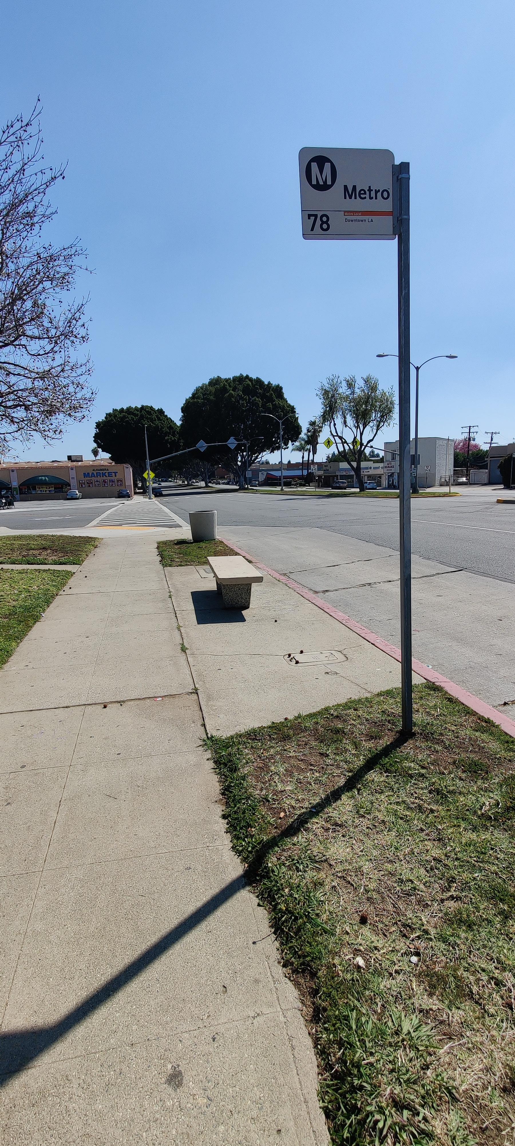 Taken by Luis R
See Main / Cedar stop, Alhambra, on the map
Public transit to Main / Cedar stop (ID: 16071) in Alhambra
Looking for directions to Main / Cedar in Alhambra, United States?
Download the Moovit App to find the current schedule and step-by-step directions for Bus or Subway routes that pass through Main / Cedar.
Looking for the nearest stops closest to Main / Cedar ? Check out this list of closest stops to your destination: Main / Primrose; South Pasadena Station; Fremont / Main; Poplar Blvd / Main St.
Bus: 78, 258, GREEN.Subway: A LINE.
We make riding on public transit to Main / Cedar easy, which is why over 1.7 billion users, including users in Alhambra trust Moovit as the best app for public transit.
Use the app to navigate to popular places including to the airport, hospital, stadium, grocery store, mall, coffee shop, school, college, and university.
Main / Cedar stop’s code is 16071
The first line to this stop is 78, at 4:31 AM, and the last line is 78 at 12:28 AM.
2315 W Main St, Alhambra, CA, USA
This stop serves Metro’s lines
- Main / Primrose,
- Fremont / Main,
- Poplar Blvd / Main St
Bus stops near Main / Cedar stop
- South Pasadena Station
Subway station near Main / Cedar station
- San Pedro & Vernon (CW),
- Mona Blvd & Santa Ana Blvd (Southbound),
- Main St / Mariposa Ave.,
- Wilshire / Western Station,
- Slauson & Hoover St. (CW),
- Cherry & Willow SW,
- Lakewood / Bellflower,
- Central / Olympic,
- Del Mar Station,
- Parthenia St & Tampa Ave (Westbound),
- Painter/Lambert,
- Rosecrans Ave & Inglewood Ave,
- Lakewood / Imperial,
- Carson St + Figueroa St,
- Long Beach Blvd. at Del Amo,
- Tampa / Nordhoff,
- Olympic / La Brea,
- Encino Park & Ride (Southbound),
- Telephone & Kimball,
- Sun Valley Metrolink Station
Popular public transit stations in Alhambra
Get around Alhambra by public transit!
Traveling around Alhambra has never been so easy. See step by step directions as you travel to any attraction, street or major public transit station. View bus and train schedules, arrival times, service alerts and detailed routes on a map, so you know exactly how to get to anywhere in Alhambra.
When traveling to any destination around Alhambra use Moovit's Live Directions with Get Off Notifications to know exactly where and how far to walk, how long to wait for your line, and how many stops are left. Moovit will alert you when it's time to get off — no need to constantly re-check whether yours is the next stop.
Wondering how to use public transit in Alhambra or how to pay for public transit in Alhambra? Moovit public transit app can help you navigate your way with public transit easily, and at minimum cost. It includes public transit fees, ticket prices, and costs. Looking for a map of Alhambra public transit lines? Moovit public transit app shows all public transit maps in Alhambra with all Bus, Train, Subway, Ferry and Funicular routes and stops on an interactive map.
Los Angeles has 5 transit type(s), including: Bus, Train, Subway, Ferry and Funicular, operated by several transit agencies, including Metro, Metro Event Service, Alhambra Community Transit (ACT), Arcadia Transit, Artesia Transit, AVTA, Baldwin Park Transit, Beach Cities Transit, Beaumont Transit, Bell Gardens Town Trolley, Bellflower Bus, Big Blue Bus, Burbank Bus, Calabasas Trolley and Camarillo Area Transit