See Manila City Hall on the map
Directions to Manila City Hall with public transportation
The following transit lines have routes that pass near Manila City Hall
 Bus:
Bus: - Train:
How to get to Manila City Hall by bus?
Click on the bus route to see step by step directions with maps, line arrival times and updated time schedules.
How to get to Manila City Hall by train?
Click on the train route to see step by step directions with maps, line arrival times and updated time schedules.
Bus stations near Manila City Hall
- Padre Burgos / Taft Ave Intersection St, Manila,2 min walk,
- Taft Ave, Manila,2 min walk,
- Padre Burgos St / Taft Ave, Manila,4 min walk,
- Padre Burgos St, Manila,4 min walk,
- Justice Cecilia Munoz-Palma, Manila,5 min walk,
Train stations near Manila City Hall
- Pedro Gil Lrt,9 min walk,
- Recto Lrt,33 min walk,
Bus lines to Manila City Hall
- JEEP,BACLARAN - MCU via MABINI,
- JEEP,Cubao - Pier South via Espana,
- JEEP,PagAsa Pier South via Qave,
- JEEP,Malinta Pier via Monumento,
- JEEP,KAMUNING PIER SOUTH via RODRIGUEZ,
- JEEP,PROJ 2&3-VITO CRUZ MABINI,
- JEEP,MCU LIBERTADvi MABINIF HARRISON,
- JEEP,FAIRVIEW (WET MARKET) - TM KALAW via Q AVE,
- JEEP,Arroceros - Proj. 2 & 3 via Kamuning E. Rodriguez,
- JEEP,Baclaran - Q.I.via Mabini,
- JEEP,Baclaran - P. Campa via Mabini,
- JEEP,Libertad QI via Mabini,
- JEEP,DAPITAN - PIER SOUTH,
- JEEP,Philcoa - T.M. Kalaw via Quezon Ave.,
- JEEP,Monumento - Pasay Rotonda via Rizal Ave., Mabini,
- JEEP,Baclaran - Blumentritt via L. Guinto, Sta. Cruz,
- JEEP,Blumentritt - Pasay RTDA. via Quiapo, L. Guinto,
- JEEP,Malanday - Pier South via Rizal Ave., P. Burgos,
- JEEP,Proj. 8 - T.M. Kalaw via Quezon Ave.,
- JEEP,Baclaran - Blumentritt via Mabini, Sta. Cruz,
What are the closest stations to Manila City Hall?
The closest stations to Manila City Hall are:
- Padre Burgos / Taft Ave Intersection St, Manila is 87 meters away, 2 min walk.
- Taft Ave, Manila is 108 meters away, 2 min walk.
- Padre Burgos St / Taft Ave, Manila is 177 meters away, 4 min walk.
- Padre Burgos St, Manila is 205 meters away, 4 min walk.
- Justice Cecilia Munoz-Palma, Manila is 273 meters away, 5 min walk.
- Pedro Gil Lrt is 579 meters away, 9 min walk.
- Recto Lrt is 2527 meters away, 33 min walk.
Which bus lines stop near Manila City Hall?
These bus lines stop near Manila City Hall: BUS, JEEP, UV.
Which train line stops near Manila City Hall?
LRT 1
What’s the nearest train station to Manila City Hall?
The nearest train station to Manila City Hall is Pedro Gil Lrt. It’s a 9 min walk away.
What’s the nearest bus stop to Manila City Hall?
The nearest bus stops to Manila City Hall are Padre Burgos / Taft Ave Intersection St, Manila and Taft Ave, Manila. The closest one is a 2 min walk away.
What time is the first train to Manila City Hall?
The LRT 2 is the first train that goes to Manila City Hall. It stops nearby at 5:00 AM.
What time is the last train to Manila City Hall?
The LRT 1 is the last train that goes to Manila City Hall. It stops nearby at 10:36 PM.
What time is the first bus to Manila City Hall?
The BUS is the first bus that goes to Manila City Hall. It stops nearby at 3:27 AM.
What time is the last bus to Manila City Hall?
The BUS is the last bus that goes to Manila City Hall. It stops nearby at 3:31 AM.
See Manila City Hall on the map
Public Transportation to Manila City Hall
Wondering how to get to Manila City Hall, Philippines? Moovit helps you find the best way to get to Manila City Hall with step-by-step directions from the nearest public transit station.
Moovit provides free maps and live directions to help you navigate through your city. View schedules, routes, timetables, and find out how long does it take to get to Manila City Hall in real time.
Looking for the nearest stop or station to Manila City Hall? Check out this list of stops closest to your destination: Padre Burgos / Taft Ave Intersection St; Taft Ave; Padre Burgos St / Taft Ave; Padre Burgos St; Justice Cecilia Munoz-Palma; Pedro Gil Lrt; Recto Lrt.
Bus:Train:
Want to see if there’s another route that gets you there at an earlier time? Moovit helps you find alternative routes or times. Get directions from and directions to Manila City Hall easily from the Moovit App or Website.
We make riding to Manila City Hall easy, which is why over 1.5 million users, including users in Manila, trust Moovit as the best app for public transit. You don’t need to download an individual bus app or train app, Moovit is your all-in-one transit app that helps you find the best bus time or train time available.
For information on prices of bus and train, costs and ride fares to Manila City Hall, please check the Moovit app.
Use the app to navigate to popular places including to the airport, hospital, stadium, grocery store, mall, coffee shop, school, college, and university.
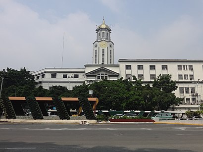
Manila City Hall Address: Taft Avenue street in Manila
Attractions near Manila City Hall
Manila City Hall (Sheriff's Office, Manila City Hall),Manila City Hall (Manila City Hall, City Government of Manila),Jed Diagnostic Center, Ermita, Manila,Atty. Rossi M. Castro,YMCA BLDG,Taft Avenue Gate,Maxicare,Tees #Ootd Republic,Pet Cafe,Blessing Ofw International Training and Assessment Center,Fortune Mansion Seafoods Restaurant Inc.,Ranz Kyle and Niana Guerrero,BSP-National Scout Shop Online Store,Lagusnilad,Packo's Bar and Restaurant Manila,Padre Burgos Avenue,Balik Manggagawa Processing Center,YMCA of the Philippines Manila,Metropolitan Trial Court Branch 13-30,Padre Burgos / Taft Ave Intersection St, ManilaHow to get to popular attractions in Manila with public transit
鹿港小鎮 Lugang Café,San Antonio de Padua Parish, Parañaque,NLEx Marilao Exit, Bulacan,Susana Heights Bus Stop, Muntinlupa,Adventist Medical Center Manila,San Benissa Garden Villas, Quezon City,Manila-Cavite Expressway (CavitEx), Las Piñas,NAIA 1 Arrival Area,Bayan Novaliches, Quezon City,Bambang Street, Manila,Sta Rosa Exit, Santa Rosa City,Starmall, Bulacan,Turo, Bocaue, Bulacan, Bulacan,Newport City,The Legend Hong Kong Seafood Restaurant,North Fairview Park Subdivision, Quezon City,Camella Gate Ayala Van Terminal, Bacoor,The SM Store,Sykes Asia Inc. K-Pointe, Quezon City,J.CO Donuts & Coffee, ImusGet around Manila by public transit!
Traveling around Manila has never been so easy. See step by step directions as you travel to any attraction, street or major public transit station. View bus and train schedules, arrival times, service alerts and detailed routes on a map, so you know exactly how to get to anywhere in Manila.
When traveling to any destination around Manila use Moovit's Live Directions with Get Off Notifications to know exactly where and how far to walk, how long to wait for your line, and how many stops are left. Moovit will alert you when it's time to get off — no need to constantly re-check whether yours is the next stop.
Wondering how to use public transit in Manila or how to pay for public transit in Manila? Moovit public transit app can help you navigate your way with public transit easily, and at minimum cost. It includes public transit fees, ticket prices, and costs. Looking for a map of Manila public transit lines? Moovit public transit app shows all public transit maps in Manila with all bus or train routes and stops on an interactive map.
Manila has 2 transit type(s), including: bus or train, operated by several transit agencies, including MRTC, LRTA, PNR, LTFRB, BGC Bus, P2P and UV Express