Metropolitan Transport Network Offline Map (PDF)
Moovit has an easy-to-download Metropolitan Transport Network map, that serves as your offline Rio de Janeiro Region light rail, ferry, bus, train or metro map while traveling. This map can be saved in your phone and it’s easy to share with friends. To view the downloaded map, no internet connection is required. It’s the offline light rail, ferry, bus, train or metro map in Rio de Janeiro Region that will take you where you need to go.
Moovit has an easy-to-download Metropolitan Transport Network map, that serves as your offline Rio de Janeiro Region light rail, ferry, bus, train or metro map while traveling. This map can be saved in your phone and it’s easy to share with friends. To view the downloaded map, no internet connection is required. It’s the offline light rail, ferry, bus, train or metro map in Rio de Janeiro Region that will take you where you need to go.
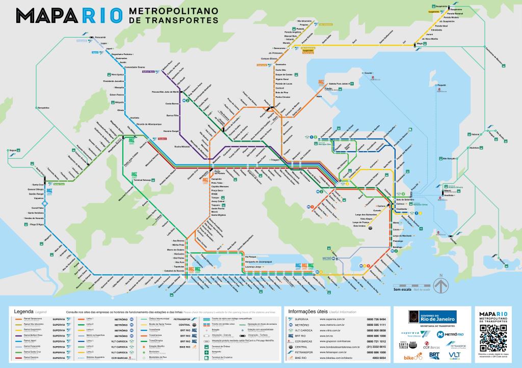
Find all light rail line schedules and routes in Rio de Janeiro Region:
- Mato Alto - Alvorada (Expresso)
 13
13 - Pontal - Jardim Oceânico (Expresso)18
- Pingo D'água - Salvador Allende (Expresso)19
- Deodoro - Recreio (Parador)51
- Santa Cruz - Salvador Allende (Expresso)20
- Centro Olímpico - Jardim Oceânico (Parador - Via Alvorada)50
- Central do Brasil - Belford Roxo

- Central do Brasil - DeodoroRAMAL DEODORO
- Alvorada - Penha (Expresso)46
- Central do Brasil - Saracuruna

- Santa Cruz - Alvorada (Expresso)10
- Santos Dumont ✈

- Santa Cruz - Alvorada (Parador)11
- Praia Formosa

- Pingo D'água - Alvorada12
- Central do Brasil - Japeri

- Mangaratiba - Ilha GrandeMANGARATIBA - ILHA GRANDE
- Paulo da Portela - Recreio (Expresso)41
- Vicente de Carvalho - Alvorada (Semidireto)31
- Alvorada - Paulo da Portela (Parador)35