Directions to Medical Reserve Corps (Brookline) with public transportation
The following transit lines have routes that pass near Medical Reserve Corps
 Bus: 65, 66, GREEN LINE D SHUTTLE, GREEN LINE D SHUTTLE, GREEN LINE D SHUTTLE.
- Train: FRAMINGHAM/WORCESTER, PROVIDENCE/STOUGHTON.
- Subway: GREEN LINE D, GREEN LINE C, GREEN LINE E.
How to get to Medical Reserve Corps by bus?
Click on the bus route to see step by step directions with maps, line arrival times and updated time schedules.
From Fan Pier Park, Boston
64 minFrom Bentley University, Waltham
77 minFrom Lasell College, Newton
90 minFrom Six Flags New England, Newton
48 minFrom Homewood Suites by Hilton Boston Logan Airport Chelsea, Chelsea
89 minFrom Massachusetts Water Resource Authority (MWRA), Chelsea
85 minFrom Staybridge Suites Boston-Quincy, Quincy
105 minFrom Canobie Lake Park, Chelsea
99 minFrom North End, Boston
64 minFrom Massport Security Badge Office, Boston
43 min
How to get to Medical Reserve Corps by train?
Click on the train route to see step by step directions with maps, line arrival times and updated time schedules.
How to get to Medical Reserve Corps by subway?
Click on the subway route to see step by step directions with maps, line arrival times and updated time schedules.
Subway stations near Medical Reserve Corps in Brookline
Bus stops near Medical Reserve Corps in Brookline
Bus lines to Medical Reserve Corps in Brookline
- 65, Kenmore,VIEW
- 66, Nubian Via Allston,VIEW
- GREEN LINE D SHUTTLE, Newton Highlands (Shuttle),VIEW
- GREEN LINE D SHUTTLE, Brookline Village (Shuttle),VIEW
- GREEN LINE D SHUTTLE, Kenmore (Shuttle),VIEW
- GREEN LINE D SHUTTLE, Riverside (Shuttle),VIEW
- 60, Chestnut Hill Mall,VIEW
- GREEN LINE D SHUTTLE, Brookline Hills (Shuttle),VIEW
What are the closest stations to Medical Reserve Corps?
The closest stations to Medical Reserve Corps are:
- Summit Avenue is 101 yards away, 2 min walk.
- Washington St @ Harvard St is 127 yards away, 2 min walk.
- Harvard St @ Washington St is 184 yards away, 3 min walk.
- Brookline Village is 344 yards away, 5 min walk.
- Brookline Village - Pearl St @ Brookline Place Parking is 476 yards away, 6 min walk.
- Pearl St @ Brookline Village is 495 yards away, 6 min walk.
- Riverway is 864 yards away, 11 min walk.
Which bus lines stop near Medical Reserve Corps?
These bus lines stop near Medical Reserve Corps: 65, 66.
Which train lines stop near Medical Reserve Corps?
These train lines stop near Medical Reserve Corps: FRAMINGHAM/WORCESTER, PROVIDENCE/STOUGHTON.
Which subway line stops near Medical Reserve Corps?
GREEN LINE D (Riverside)
What’s the nearest subway station to Medical Reserve Corps in Brookline?
The nearest subway station to Medical Reserve Corps in Brookline is Summit Avenue. It’s a 2 min walk away.
What’s the nearest bus station to Medical Reserve Corps in Brookline?
The nearest bus station to Medical Reserve Corps in Brookline is Washington St @ Harvard St. It’s a 2 min walk away.
What time is the first subway to Medical Reserve Corps in Brookline?
The GREEN LINE D is the first subway that goes to Medical Reserve Corps in Brookline. It stops nearby at 4:51 AM.
What time is the last subway to Medical Reserve Corps in Brookline?
The GREEN LINE D is the last subway that goes to Medical Reserve Corps in Brookline. It stops nearby at 2:26 AM.
What time is the first bus to Medical Reserve Corps in Brookline?
The 60 is the first bus that goes to Medical Reserve Corps in Brookline. It stops nearby at 4:55 AM.
What time is the last bus to Medical Reserve Corps in Brookline?
The 66 is the last bus that goes to Medical Reserve Corps in Brookline. It stops nearby at 2:19 AM.
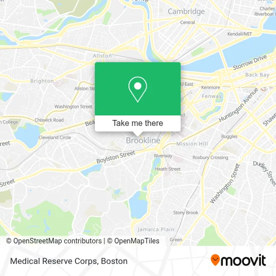
See Medical Reserve Corps, Brookline, on the map
Public Transit to Medical Reserve Corps in Brookline
Wondering how to get to Medical Reserve Corps in Brookline? Moovit helps you find the best way to get to Medical Reserve Corps with step-by-step directions from the nearest public transit station.
Moovit provides free maps and live directions to help you navigate through your city. View schedules, routes, timetables, and find out how long does it take to get to Medical Reserve Corps in real time.
Looking for the nearest stop or station to Medical Reserve Corps? Check out this list of stops closest to your destination: Summit Avenue; Washington St @ Harvard St; Harvard St @ Washington St; Brookline Village; Brookline Village - Pearl St @ Brookline Place Parking; Pearl St @ Brookline Village; Riverway.
Bus: 65, 66, GREEN LINE D SHUTTLE, GREEN LINE D SHUTTLE, GREEN LINE D SHUTTLE, GREEN LINE D SHUTTLE.Train: FRAMINGHAM/WORCESTER, PROVIDENCE/STOUGHTON.Subway: GREEN LINE D, GREEN LINE C, GREEN LINE E.
Want to see if there’s another route that gets you there at an earlier time? Moovit helps you find alternative routes or times. Get directions from and directions to Medical Reserve Corps easily from the Moovit App or Website.
We make riding to Medical Reserve Corps easy, which is why over 1.7 million users, including users in Brookline, trust Moovit as the best app for public transit. You don’t need to download an individual bus app or train app, Moovit is your all-in-one transit app that helps you find the best bus time or train time available.
For information on prices of bus, subway and train, costs and ride fares to Medical Reserve Corps, please check the Moovit app.
Use the app to navigate to popular places including to the airport, hospital, stadium, grocery store, mall, coffee shop, school, college, and university.
Medical Reserve Corps Address: 11 Pierce St street in Brookline
- Pierce Elementary School K-8 50 School Elementary School,
- Village Studio,
- Public Schools of Brookline,
- Muddy River Restoration,
- 15 Minute Response Locksmith,
- Boston Life,
- Church Of The Assumption,
- Brookline, Massachusetts,
- Brookline Municipal Court,
- AMTRACK Maintenace Facility / Train Yard,
- Warhammer,
- Philip's TV & Video,
- Kent & Webster-Parking Lot 6,
- Garrison House,
- Riverwalk Church,
- Messias R Oliveria Junior,
- Julie Yeterian PHD,
- MoneyGram,
- Gentle Hands Doula,
- Trust Early Learners
Places Near Medical Reserve Corps (Brookline)
- Mgm Music Hall, Boston,
- Leader Bank Pavilion (Leader Bank Pavillion), Boston,
- Boston Medical Center, Boston,
- Isabella Stewart Gardner Museum, Boston,
- Boston Children's Hospital, Boston,
- Seaport District, Boston,
- North End, Boston,
- Cheers, Boston,
- Wang Theater, Boston,
- Boston Convention & Exhibition Center, Boston,
- Castle Island, Boston,
- Quincy Market, Boston,
- Museum Of Science, Boston,
- Faneuil Hall, Boston,
- Td Garden, Boston,
- Boston Common, Boston,
- Wilbur Theatre, Boston,
- Prudential Center, Boston,
- Massachusetts General Hospital, Boston,
- House Of Blues, Boston
How to get to popular places in Boston with public transit
Get around Brookline by public transit!
Traveling around Brookline has never been so easy. See step by step directions as you travel to any attraction, street or major public transit station. View bus and train schedules, arrival times, service alerts and detailed routes on a map, so you know exactly how to get to anywhere in Brookline.
When traveling to any destination around Brookline use Moovit's Live Directions with Get Off Notifications to know exactly where and how far to walk, how long to wait for your line, and how many stops are left. Moovit will alert you when it's time to get off — no need to constantly re-check whether yours is the next stop.
Wondering how to use public transit in Brookline or how to pay for public transit in Brookline? Moovit public transit app can help you navigate your way with public transit easily, and at minimum cost. It includes public transit fees, ticket prices, and costs. Looking for a map of Brookline public transit lines? Moovit public transit app shows all public transit maps in Brookline with all Bus, Train, Subway and Ferry routes and stops on an interactive map.
Boston has 4 transit type(s), including: Bus, Train, Subway and Ferry, operated by several transit agencies, including MBTA, Southeastern Regional Transit Authority, MetroWest Regional Transit Authority, Rhode Island Public Transit Authority, WRTA, Lowell Regional Transit Authority, Merrimack Valley Transit, Montachusett Regional Transit Authority, Cape Cod Regional Transit Authority, Brockton Area Transit Authority, Martha's Vineyard Transit Authority, the WAVE - Nantucket Regional Transit Authority, GATRA, Cape Ann Transportation Authority and Massport