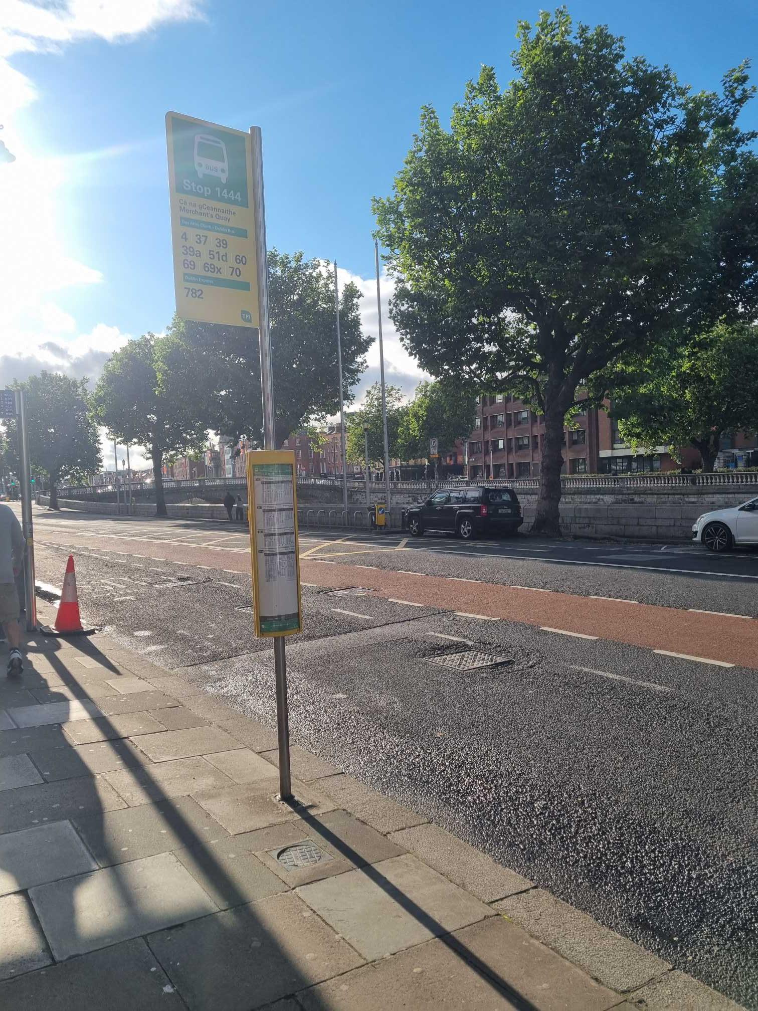
Merchant's Quay stop - Wednesday schedule
| Line | Direction | Time |
|---|---|---|
| 39A | Ongar | 3:25 AM |
| 782 | Terminal 1 Zone 1 | 3:32 AM |
| 782 | Custom Hse Quay | 3:32 AM |
| 24 | Dublin Airport | 3:42 AM |
| 39A | Ongar | 3:51 AM |
| 782 | Terminal 1 Zone 1 | 4:02 AM |
| 782 | Custom Hse Quay | 4:02 AM |
| 24 | Dublin Airport | 4:12 AM |
| 39A | Ongar | 4:21 AM |
| 782 | Terminal 1 Zone 1 | 4:32 AM |
| 782 | Custom Hse Quay | 4:32 AM |
| 24 | Dublin Airport | 4:42 AM |
| 39A | Ongar | 4:51 AM |
| 782 | Terminal 1 Zone 1 | 5:02 AM |
| 782 | Custom Hse Quay | 5:02 AM |
| 24 | Dublin Airport | 5:12 AM |
| 39A | Ongar | 5:21 AM |
| 782 | Terminal 1 Zone 1 | 5:32 AM |
| 782 | Custom Hse Quay | 5:32 AM |
| 24 | Dublin Airport | 5:32 AM |
| 60 | Red Cow Luas | 5:41 AM |
| 24 | Dublin Airport | 5:53 AM |
| 39A | Ongar | 5:56 AM |
| 23 | Charlestown | 6:02 AM |
| 782 | Custom Hse Quay | 6:08 AM |
Directions to Merchant's Quay stop (Dublin) with public transit
The following transit lines have routes that pass near Merchant's Quay
 Bus: 23, 24, 39A, 60, 69.
- Train: DART.
How to get to Merchant's Quay stop by bus?
Click on the bus route to see step by step directions with maps, line arrival times and updated time schedules.
How to get to Merchant's Quay stop by train?
Click on the train route to see step by step directions with maps, line arrival times and updated time schedules.
Bus stops near Merchant's Quay stop in Dublin
- Bridge Street, 3 min walk,
- Winetavern Street, 3 min walk,
- Four Courts, 4 min walk,
- Inns Quay, 4 min walk,
- Cornmarket, 6 min walk,
Light Rail stations near Merchant's Quay station in Dublin
- Four Courts, 5 min walk,
Bus lines to Merchant's Quay stop in Dublin
- S2, Heuston Station,
- G1, Red Cow Luas,
- G2, Liffey Valley Sc,
- 74, Dundrum,
- 73, Griffith Ave E,
- 4, Monkstown Ave,
- 37, Bachelor's Walk,
- 39, Burlington Road,
- 39A, Ucd,
- 39X, Burlington Road,
- 51D, Waterloo Rd,
- 70, Burlington Road,
- C1, Sandymount,
- C2, Sandymount,
- C3, Ringsend Road,
- C4, Ringsend Road,
- C5, Ringsend Road,
- C6, Ringsend Road,
- 23, Charlestown,
- 24, Merrion Square,
What are the closest stations to Merchant's Quay?
The closest stations to Merchant's Quay are:
- Bridge Street stop is 170 meters away, 3 min walk.
- Winetavern Street stop is 213 meters away, 3 min walk.
- Four Courts stop is 269 meters away, 4 min walk.
- Inns Quay stop is 295 meters away, 4 min walk.
- Cornmarket stop is 414 meters away, 6 min walk.
Which bus lines stop near Merchant's Quay?
These bus lines stop near Merchant's Quay: 23, 24, 39A, 60, 69, 80, C3.
Which train line stops near Merchant's Quay?
DART (Malahide→Bray (Daly))
What’s the nearest light rail station to Merchant's Quay in Dublin?
The nearest light rail station to Merchant's Quay in Dublin is Four Courts. It’s a 5 min walk away.
What’s the nearest bus station to Merchant's Quay in Dublin?
The nearest bus stations to Merchant's Quay in Dublin are Bridge Street and Winetavern Street. The closest one is a 3 min walk away.
What time is the first light rail to Merchant's Quay in Dublin?
The RED is the first light rail that goes to Merchant's Quay in Dublin. It stops nearby at 5:41 AM.
What time is the last light rail to Merchant's Quay in Dublin?
The RED is the last light rail that goes to Merchant's Quay in Dublin. It stops nearby at 12:45 AM.
What time is the first bus to Merchant's Quay in Dublin?
The C2 is the first bus that goes to Merchant's Quay in Dublin. It stops nearby at 3:00 AM.
What time is the last bus to Merchant's Quay in Dublin?
The C1 is the last bus that goes to Merchant's Quay in Dublin. It stops nearby at 3:27 AM.
Merchant's Quay station
 Taken by Anonymous
See Merchant's Quay stop, Dublin, on the map
Public transit to Merchant's Quay stop (ID: 1444) in Dublin
Looking for directions to Merchant's Quay in Dublin, Ireland?
Download the Moovit App to find the current schedule and step-by-step directions for Bus, Train or Light Rail routes that pass through Merchant's Quay.
Looking for the nearest stops closest to Merchant's Quay ? Check out this list of closest stops to your destination: Bridge Street; Winetavern Street; Four Courts; Inns Quay; Cornmarket.
Bus: 23, 24, 39A, 60, 69, 80, C3, S2, G1, G2, 74, 73, 4, 37, 39, 39X, C1, C2, C4, C5, 783.Train: DART.
We make riding on public transit to Merchant's Quay easy, which is why over 1.7 billion users, including users in Dublin trust Moovit as the best app for public transit.
Use the app to navigate to popular places including to the airport, hospital, stadium, grocery store, mall, coffee shop, school, college, and university.
Merchant's Quay stop’s code is 1444
The first line to this stop is 39A, at 3:25 AM, and the last line is 39A at 2:55 AM.
19 Merchant's Quay, Dublin, Ireland
This stop serves Bus Átha Cliath – Dublin Bus, Dublin Express and Nitelink, Dublin Bus’s lines
Popular routes from Merchant's Quay stop, Dublin
- Bridge Street,
- Winetavern Street,
- Four Courts,
- Inns Quay,
- Cornmarket
Bus stops near Merchant's Quay stop
- Four Courts
Light Rail station near Merchant's Quay station
- Wayfinding Centre,
- Hewlett Packard,
- Ballinteer Ave,
- Terenure Coll,
- Harold's Cross Vlge,
- Mount Tallant Ave,
- Pearse Rd,
- Ashfield House,
- Pembroke St Lwr,
- Peamount,
- Leeson Street Upper,
- Willow Court,
- De Paul Pool,
- Roebuck Downs,
- Vesey Park,
- Cork Kent Stn,
- Roosevelt Cottages,
- Navan P&R,
- Malahide Com School,
- Seamount
Popular public transit stations in Dublin
Get around Dublin by public transit!
Traveling around Dublin has never been so easy. See step by step directions as you travel to any attraction, street or major public transit station. View bus and train schedules, arrival times, service alerts and detailed routes on a map, so you know exactly how to get to anywhere in Dublin.
When traveling to any destination around Dublin use Moovit's Live Directions with Get Off Notifications to know exactly where and how far to walk, how long to wait for your line, and how many stops are left. Moovit will alert you when it's time to get off — no need to constantly re-check whether yours is the next stop.
Wondering how to use public transit in Dublin or how to pay for public transit in Dublin? Moovit public transit app can help you navigate your way with public transit easily, and at minimum cost. It includes public transit fees, ticket prices, and costs. Looking for a map of Dublin public transit lines? Moovit public transit app shows all public transit maps in Dublin with all Bus, Train and Light Rail routes and stops on an interactive map.
Ireland has 3 transit type(s), including: Bus, Train and Light Rail, operated by several transit agencies, including Luas, Bus Átha Cliath – Dublin Bus, Bus Éireann, Go-Ahead Ireland, Nitelink, Dublin Bus, Citylink, City Direct, Kenneally's Bus Service, Aircoach, TFI Local Link Mayo, Irish Rail, Express Bus, JJ/Bernard Kavanagh, Dublin Coach and Kearns Transport