Primavalle Hills/Mazzella stop - Friday schedule
| Line | Direction | Time |
|---|---|---|
| N46 | Termini (Metro A-Metro B-Railway) | 3:03 AM |
| N46 | Termini (Metro A-Metro B-Railway) | 3:03 AM |
| NMA | Battistini/Soria | 3:15 AM |
| NMA | Battistini/Soria | 3:15 AM |
| N46 | Termini (Metro A-Metro B-Railway) | 3:18 AM |
| N46 | Termini (Metro A-Metro B-Railway) | 3:18 AM |
| NMA | Battistini/Soria | 3:22 AM |
| NMA | Battistini/Soria | 3:22 AM |
| NMA | Battistini/Soria | 3:39 AM |
| NMA | Battistini/Soria | 3:39 AM |
| N46 | Termini (Metro A-Metro B-Railway) | 3:47 AM |
| N46 | Termini (Metro A-Metro B-Railway) | 3:47 AM |
| NMA | Battistini/Soria | 3:56 AM |
| NMA | Battistini/Soria | 3:56 AM |
| NMA | Battistini/Soria | 4:13 AM |
| NMA | Battistini/Soria | 4:13 AM |
| NMA | Battistini/Soria | 4:16 AM |
| N46 | Termini (Metro A-Metro B-Railway) | 4:17 AM |
| N46 | Termini (Metro A-Metro B-Railway) | 4:17 AM |
| NMA | Battistini/Soria | 4:32 AM |
| N46 | Termini (Metro A-Metro B-Railway) | 4:45 AM |
| N46 | Termini (Metro A-Metro B-Railway) | 4:45 AM |
| NMA | Battistini/Soria | 4:48 AM |
| NMA | Battistini/Soria | 5:04 AM |
| NMA | Battistini/Soria | 5:04 AM |
Directions to Primavalle Hills/Mazzella stop (Roma) with public transit
The following transit lines have routes that pass near Primavalle Hills/Mazzella
 Bus: 46, 46B, 907, 907L, 983.
- Train: FL3.
- Metro: A.
How to get to Primavalle Hills/Mazzella stop by bus?
Click on the bus route to see step by step directions with maps, line arrival times and updated time schedules.
How to get to Primavalle Hills/Mazzella stop by train?
Click on the train route to see step by step directions with maps, line arrival times and updated time schedules.
How to get to Primavalle Hills/Mazzella stop by metro?
Click on the metro route to see step by step directions with maps, line arrival times and updated time schedules.
Bus stops near Primavalle Hills/Mazzella stop in Roma
- Primavalle Hills/Mazzella, 1 min walk,
- Pasquale II/Clement XI, 4 min walk,
- Borromeo F./Clemente XI, 5 min walk,
- Battistini/Melchiade Papa, 10 min walk,
Train stations near Primavalle Hills/Mazzella station in Roma
- Gemelli, 4 min walk,
Metro stations near Primavalle Hills/Mazzella station in Roma
- Battistini, 32 min walk,
Bus lines to Primavalle Hills/Mazzella stop in Roma
- NMA, Battistini/Soria,
- 46, Piazza Venezia,
- 46B, Rosi,
- N46, Monte Mario Station (FS-FL3),
- 983, Cornelia (MA),
- 907, La Giustiniana Station,
- 907L, Cornelia,
- 916, Piazza Venezia,
- 916F, Piazza Venezia,
- 49, Cavour Square,
- 146, Mombasiglio,
- 985, Aurelia Station,
What are the closest stations to Primavalle Hills/Mazzella?
The closest stations to Primavalle Hills/Mazzella are:
- Primavalle Hills/Mazzella stop is 47 meters away, 1 min walk.
- Pasquale II/Clement XI stop is 248 meters away, 4 min walk.
- Gemelli station is 265 meters away, 4 min walk.
- Borromeo F./Clemente XI stop is 323 meters away, 5 min walk.
- Battistini/Melchiade Papa stop is 745 meters away, 10 min walk.
- Battistini station is 2513 meters away, 32 min walk.
Which bus lines stop near Primavalle Hills/Mazzella?
These bus lines stop near Primavalle Hills/Mazzella: 46, 46B, 907, 907L, 983.
Which train line stops near Primavalle Hills/Mazzella?
FL3 (Viterbo)
Which metro line stops near Primavalle Hills/Mazzella?
A (Battistini)
What’s the nearest train station to Primavalle Hills/Mazzella in Roma?
The nearest train station to Primavalle Hills/Mazzella in Roma is Gemelli. It’s a 4 min walk away.
What’s the nearest bus station to Primavalle Hills/Mazzella in Roma?
The nearest bus station to Primavalle Hills/Mazzella in Roma is Primavalle Hills/Mazzella. It’s a 1 min walk away.
What time is the first metro to Primavalle Hills/Mazzella in Roma?
The A is the first metro that goes to Primavalle Hills/Mazzella in Roma. It stops nearby at 5:30 AM.
What time is the last metro to Primavalle Hills/Mazzella in Roma?
The A is the last metro that goes to Primavalle Hills/Mazzella in Roma. It stops nearby at 12:11 AM.
What time is the first train to Primavalle Hills/Mazzella in Roma?
The FL3 is the first train that goes to Primavalle Hills/Mazzella in Roma. It stops nearby at 5:48 AM.
What time is the last train to Primavalle Hills/Mazzella in Roma?
The FL3 is the last train that goes to Primavalle Hills/Mazzella in Roma. It stops nearby at 11:09 PM.
What time is the first bus to Primavalle Hills/Mazzella in Roma?
The NMA is the first bus that goes to Primavalle Hills/Mazzella in Roma. It stops nearby at 3:01 AM.
What time is the last bus to Primavalle Hills/Mazzella in Roma?
The NMA is the last bus that goes to Primavalle Hills/Mazzella in Roma. It stops nearby at 4:02 AM.
Primavalle Hills/Mazzella station
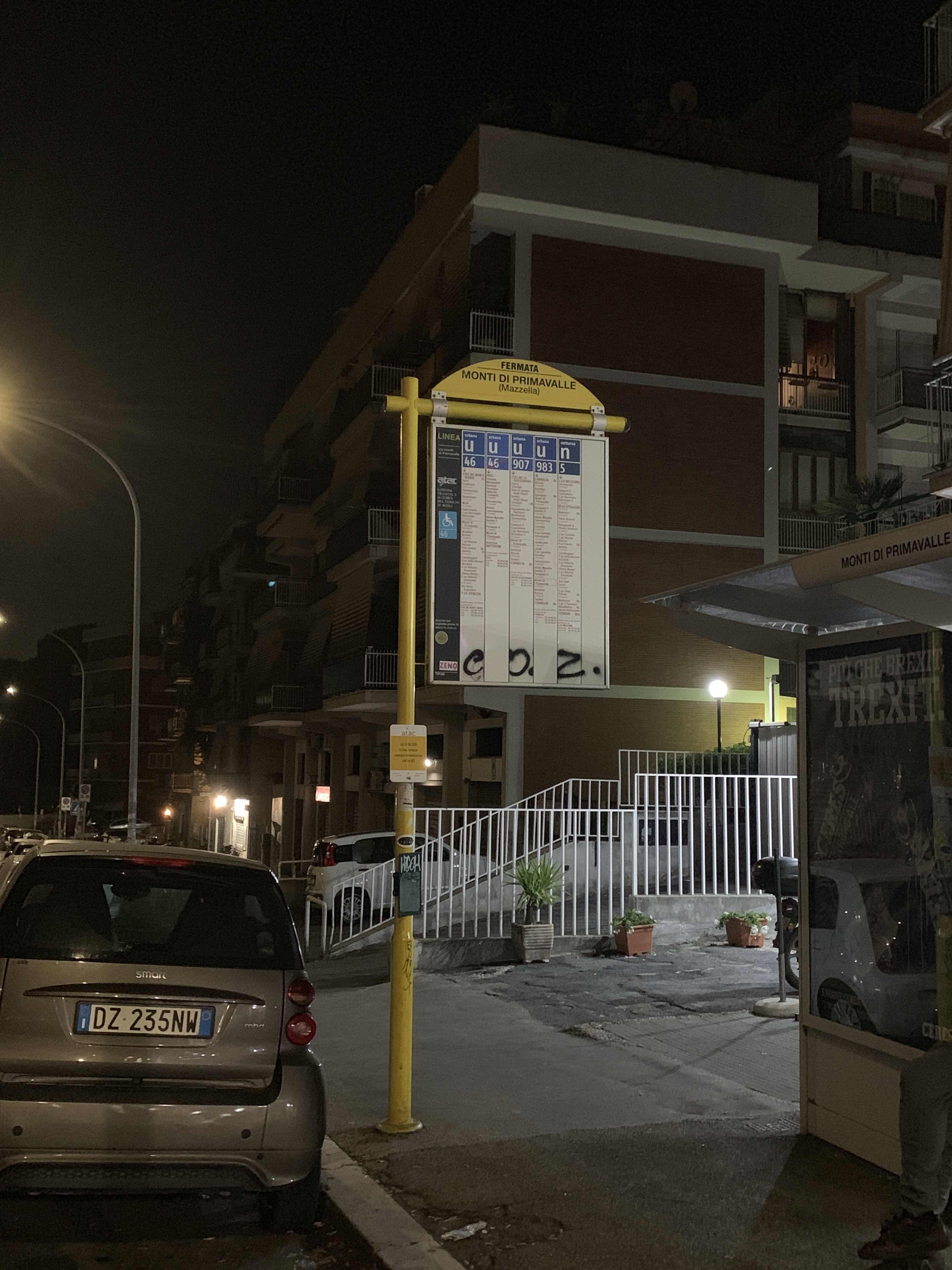 Taken by Anonymous
See Primavalle Hills/Mazzella stop, Roma, on the map
Public transit to Primavalle Hills/Mazzella stop (ID: 73142) in Roma
Looking for directions to Primavalle Hills/Mazzella in Roma, Italy?
Download the Moovit App to find the current schedule and step-by-step directions for Bus, Metro or Train routes that pass through Primavalle Hills/Mazzella.
Looking for the nearest stops closest to Primavalle Hills/Mazzella ? Check out this list of closest stops to your destination: Primavalle Hills/Mazzella; Pasquale II/Clement XI; Gemelli; Borromeo F./Clemente XI; Battistini/Melchiade Papa; Battistini.
Bus: 46, 46B, 907, 907L, 983, NMA, N46, 916, 916F, 49, 146, 985.Train: FL3.Metro: A.
We make riding on public transit to Primavalle Hills/Mazzella easy, which is why over 1.7 billion users, including users in Roma trust Moovit as the best app for public transit.
Use the app to navigate to popular places including to the airport, hospital, stadium, grocery store, mall, coffee shop, school, college, and university.
Primavalle Hills/Mazzella stop’s code is 73142
The first line to this stop is N46, at 3:03 AM, and the last line is NMA at 2:58 AM.
Via Camillo Mazzella, Roma, Italy
This stop serves ATAC and BIS’s lines
Popular routes from Primavalle Hills/Mazzella stop, Roma
- Primavalle Hills/Mazzella,
- Pasquale II/Clement XI,
- Borromeo F./Clemente XI,
- Battistini/Melchiade Papa
Bus stops near Primavalle Hills/Mazzella stop
- Gemelli
Train station near Primavalle Hills/Mazzella station
- Battistini
Metro station near Primavalle Hills/Mazzella station
- Casilina/Balzani,
- Malagrotta,
- Parioli/Santiago Del Cile,
- Terracina - Migliara 58 Macchia Road 1,
- Portuense/La Loggia,
- Due Leoni-Fontana Candida,
- Vignanello,
- Vittorio Emanuele III Avenue,
- Viterbo,
- Jonio/Talenti,
- Magna Grecia/San Giovanni (Ma-Mc),
- Arcinazzo | Highlands,
- Castel Fusano Station Avenue,
- Villa Claudia,
- Vigna Murata (Mb),
- Monte S. Biagio-Terracina Mare,
- Navicella/Villa Celimontana,
- Albano,
- Castro Pretorio,
- Adriatico/Lampedusa
Popular public transit stations in Roma
Get around Roma by public transit!
Traveling around Roma has never been so easy. See step by step directions as you travel to any attraction, street or major public transit station. View bus and train schedules, arrival times, service alerts and detailed routes on a map, so you know exactly how to get to anywhere in Roma.
When traveling to any destination around Roma use Moovit's Live Directions with Get Off Notifications to know exactly where and how far to walk, how long to wait for your line, and how many stops are left. Moovit will alert you when it's time to get off — no need to constantly re-check whether yours is the next stop.
Wondering how to use public transit in Roma or how to pay for public transit in Roma? Moovit public transit app can help you navigate your way with public transit easily, and at minimum cost. It includes public transit fees, ticket prices, and costs. Looking for a map of Roma public transit lines? Moovit public transit app shows all public transit maps in Roma with all Bus, Train, Metro, Light Rail, Ferry, Funicular and Gondola routes and stops on an interactive map.
Rome and Lazio has 7 transit type(s), including: Bus, Train, Metro, Light Rail, Ferry, Funicular and Gondola, operated by several transit agencies, including ATAC, Cotral, Trenitalia, Troiani Transportation Services, BIS, ATR Mobility, Tuscia, Shuttle, Seatour, Troiani Bus Lines, CSC Mobility, Terravision, ATRAL, Tambus and Sitbus