Directions to Mvmt·Ology (Brookline) with public transportation
The following transit lines have routes that pass near Mvmt·Ology
 Bus: 66, FLIXBUS 2610, FLIXBUS N2605, FLIXBUS N2610, GREEN LINE C SHUTTLE.
- Train: FRAMINGHAM/WORCESTER.
- Subway: GREEN LINE C.
How to get to Mvmt·Ology by bus?
Click on the bus route to see step by step directions with maps, line arrival times and updated time schedules.
From Newton Wellesley Hospital Green Building, Newton
85 minFrom Boston Harbor, Boston
56 minFrom Yankee Lobster, Boston
55 minFrom Boda Borg, Malden
88 minFrom Newton-Wellesley Hospital, Newton
85 minFrom MBTA Broadway Station, Boston
52 minFrom Courtyard by Marriott Boston Logan Airport, Boston
78 minFrom Malden, MA, Malden
93 minFrom Modern Pastry Shop, Boston
52 minFrom ICA, Boston
54 min
How to get to Mvmt·Ology by train?
Click on the train route to see step by step directions with maps, line arrival times and updated time schedules.
How to get to Mvmt·Ology by subway?
Click on the subway route to see step by step directions with maps, line arrival times and updated time schedules.
From Newton Wellesley Hospital Green Building, Newton
49 minFrom Yankee Lobster, Boston
57 minFrom Boda Borg, Malden
52 minFrom Newton-Wellesley Hospital, Newton
49 minFrom MBTA Broadway Station, Boston
34 minFrom Courtyard by Marriott Boston Logan Airport, Boston
54 minFrom Malden, MA, Malden
59 minFrom Modern Pastry Shop, Boston
36 minFrom ICA, Boston
52 min
Bus stops near Mvmt·Ology in Brookline
Subway station near Mvmt·Ology in Brookline
- Coolidge Corner, 3 min walk,VIEW
Bus lines to Mvmt·Ology in Brookline
- FLIXBUS 2610, New York (Hudson Yards),VIEW
- FLIXBUS N2605, Henrico (Parham Rd Park & Ride),VIEW
- FLIXBUS N2610, Boston (South Station),VIEW
- 66, Brighton Center Via Brookline,VIEW
- GREEN LINE C SHUTTLE, Saint Mary's Street (Shuttle),VIEW
- GREEN LINE C SHUTTLE, Coolidge Corner (Shuttle),VIEW
- SHUTTLE, Cleveland Circle (Shuttle),VIEW
What are the closest stations to Mvmt·Ology?
The closest stations to Mvmt·Ology are:
- Brookline is 117 yards away, 2 min walk.
- Harvard St @ Beacon St is 140 yards away, 2 min walk.
- Coolidge Corner is 207 yards away, 3 min walk.
Which bus line stops near Mvmt·Ology?
66 (Harvard Via Allston)
Which train line stops near Mvmt·Ology?
FRAMINGHAM/WORCESTER (#525 | Worcester)
Which subway line stops near Mvmt·Ology?
GREEN LINE C (North Station)
What’s the nearest subway station to Mvmt·Ology in Brookline?
The nearest subway station to Mvmt·Ology in Brookline is Coolidge Corner. It’s a 3 min walk away.
What’s the nearest bus station to Mvmt·Ology in Brookline?
The nearest bus stations to Mvmt·Ology in Brookline are Brookline and Harvard St @ Beacon St. The closest one is a 2 min walk away.
What time is the first subway to Mvmt·Ology in Brookline?
The GREEN LINE C is the first subway that goes to Mvmt·Ology in Brookline. It stops nearby at 5:06 AM.
What time is the last subway to Mvmt·Ology in Brookline?
The GREEN LINE C is the last subway that goes to Mvmt·Ology in Brookline. It stops nearby at 2:16 AM.
What time is the first bus to Mvmt·Ology in Brookline?
The 66 is the first bus that goes to Mvmt·Ology in Brookline. It stops nearby at 5:00 AM.
What time is the last bus to Mvmt·Ology in Brookline?
The FLIXBUS N2605 is the last bus that goes to Mvmt·Ology in Brookline. It stops nearby at 9:05 AM.
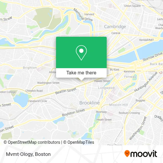
See Mvmt·Ology, Brookline, on the map
Public Transit to Mvmt·Ology in Brookline
Wondering how to get to Mvmt·Ology in Brookline? Moovit helps you find the best way to get to Mvmt·Ology with step-by-step directions from the nearest public transit station.
Moovit provides free maps and live directions to help you navigate through your city. View schedules, routes, timetables, and find out how long does it take to get to Mvmt·Ology in real time.
Looking for the nearest stop or station to Mvmt·Ology? Check out this list of stops closest to your destination: Brookline; Harvard St @ Beacon St; Coolidge Corner.
Bus: 66, FLIXBUS 2610, FLIXBUS N2605, FLIXBUS N2610, GREEN LINE C SHUTTLE, GREEN LINE C SHUTTLE, SHUTTLE.Train: FRAMINGHAM/WORCESTER.Subway: GREEN LINE C.
Want to see if there’s another route that gets you there at an earlier time? Moovit helps you find alternative routes or times. Get directions from and directions to Mvmt·Ology easily from the Moovit App or Website.
We make riding to Mvmt·Ology easy, which is why over 1.7 million users, including users in Brookline, trust Moovit as the best app for public transit. You don’t need to download an individual bus app or train app, Moovit is your all-in-one transit app that helps you find the best bus time or train time available.
For information on prices of subway, bus and train, costs and ride fares to Mvmt·Ology, please check the Moovit app.
Use the app to navigate to popular places including to the airport, hospital, stadium, grocery store, mall, coffee shop, school, college, and university.
Mvmt·Ology Address: 318 Harvard St street in Brookline
- Rachel Berger,
- Verdant Landscape Architecture,
- Sorriso Wine & Bottle Shop,
- Brookline Barbershop,
- Skin Care by Stavroula,
- Buffalo Exchange,
- Parlour,
- Bell86,
- Boston Veterinary Clinic,
- Good Vibrations Brookline Store,
- Zaftigs Delicatessen,
- Healthworks Fitness Centers (Healthworks Fitness for Women),
- Hidalgo Salon,
- Nail Monster,
- Joel Weingarten,
- Tushar Hazra,
- Herbert Wilson,
- George Young,
- Maruichi,
- Wangpc Computer Service
Places Near Mvmt·Ology (Brookline)
- North End, Boston,
- House Of Blues, Boston,
- Seaport District, Boston,
- Prudential Center, Boston,
- Castle Island, Boston,
- Td Garden, Boston,
- Massachusetts General Hospital, Boston,
- Cheers, Boston,
- Museum Of Science, Boston,
- Boston Medical Center, Boston,
- Wilbur Theatre, Boston,
- Isabella Stewart Gardner Museum, Boston,
- Leader Bank Pavilion (Leader Bank Pavillion), Boston,
- Boston Common, Boston,
- Boston Children's Hospital, Boston,
- Mgm Music Hall, Boston,
- Faneuil Hall, Boston,
- Wang Theater, Boston,
- Boston Convention & Exhibition Center, Boston,
- Quincy Market, Boston
How to get to popular places in Boston with public transit
Get around Brookline by public transit!
Traveling around Brookline has never been so easy. See step by step directions as you travel to any attraction, street or major public transit station. View bus and train schedules, arrival times, service alerts and detailed routes on a map, so you know exactly how to get to anywhere in Brookline.
When traveling to any destination around Brookline use Moovit's Live Directions with Get Off Notifications to know exactly where and how far to walk, how long to wait for your line, and how many stops are left. Moovit will alert you when it's time to get off — no need to constantly re-check whether yours is the next stop.
Wondering how to use public transit in Brookline or how to pay for public transit in Brookline? Moovit public transit app can help you navigate your way with public transit easily, and at minimum cost. It includes public transit fees, ticket prices, and costs. Looking for a map of Brookline public transit lines? Moovit public transit app shows all public transit maps in Brookline with all Bus, Train, Subway and Ferry routes and stops on an interactive map.
Boston has 4 transit type(s), including: Bus, Train, Subway and Ferry, operated by several transit agencies, including MBTA, Southeastern Regional Transit Authority, MetroWest Regional Transit Authority, Rhode Island Public Transit Authority, WRTA, Lowell Regional Transit Authority, Merrimack Valley Transit, Montachusett Regional Transit Authority, Cape Cod Regional Transit Authority, Brockton Area Transit Authority, Martha's Vineyard Transit Authority, the WAVE - Nantucket Regional Transit Authority, GATRA, Cape Ann Transportation Authority and Massport