Ne 10 Av & Ne 196 Te stop - Sunday schedule
| Line | Direction | Time |
|---|---|---|
| 199 | 199 - Red Rd Transit Hub | 5:11 AM |
| 199 | 199 - Aventura Mall Terminal | 5:46 AM |
| 199 | 199 - Red Rd Transit Hub | 6:11 AM |
| 199 | 199 - Aventura Mall Terminal | 6:34 AM |
| 199 | 199 - Red Rd Transit Hub | 7:15 AM |
| 199 | 199 - Aventura Mall Terminal | 7:29 AM |
| 199 | 199 - Aventura Mall Terminal | 7:58 AM |
| 199 | 199 - Red Rd Transit Hub | 8:15 AM |
| 199 | 199 - Aventura Mall Terminal | 8:28 AM |
| 199 | 199 - Red Rd Transit Hub | 8:45 AM |
| 199 | 199 - Aventura Mall Terminal | 9:02 AM |
| 199 | 199 - Red Rd Transit Hub | 9:15 AM |
| 199 | 199 - Aventura Mall Terminal | 9:31 AM |
| 199 | 199 - Red Rd Transit Hub | 9:45 AM |
| 199 | 199 - Aventura Mall Terminal | 10:01 AM |
| 199 | 199 - Red Rd Transit Hub | 10:15 AM |
| 199 | 199 - Aventura Mall Terminal | 10:31 AM |
| 199 | 199 - Red Rd Transit Hub | 10:45 AM |
| 199 | 199 - Aventura Mall Terminal | 11:01 AM |
| 199 | 199 - Red Rd Transit Hub | 11:15 AM |
| 199 | 199 - Aventura Mall Terminal | 11:31 AM |
| 199 | 199 - Red Rd Transit Hub | 11:45 AM |
| 199 | 199 - Aventura Mall Terminal | 12:01 PM |
| 199 | 199 - Red Rd Transit Hub | 12:15 PM |
| 199 | 199 - Aventura Mall Terminal | 12:31 PM |
Directions to Ne 10 Av & Ne 196 Te stop (Miami) with public transit
The following transit lines have routes that pass near Ne 10 Av & Ne 196 Te
 Bus: 199.
- Train: BLFM.
How to get to Ne 10 Av & Ne 196 Te stop by bus?
Click on the bus route to see step by step directions with maps, line arrival times and updated time schedules.
Bus stops near Ne 10 Av & Ne 196 Te stop in Miami
- Ne 10 Av & Ne 196 Te, 2 min walk,
Train stations near Ne 10 Av & Ne 196 Te station in Miami
- Aventura, 29 min walk,
Bus lines to Ne 10 Av & Ne 196 Te stop in Miami
- 199, 199 - Aventura Mall Terminal,
What are the closest stations to Ne 10 Av & Ne 196 Te?
The closest stations to Ne 10 Av & Ne 196 Te are:
- Ne 10 Av & Ne 196 Te stop is 126 yards away, 2 min walk.
- Aventura station is 2480 yards away, 29 min walk.
Which bus line stops near Ne 10 Av & Ne 196 Te?
199 (199 - Red Rd Transit Hub)
What’s the nearest train station to Ne 10 Av & Ne 196 Te in Miami?
The nearest train station to Ne 10 Av & Ne 196 Te in Miami is Aventura. It’s a 29 min walk away.
What’s the nearest bus station to Ne 10 Av & Ne 196 Te in Miami?
The nearest bus station to Ne 10 Av & Ne 196 Te in Miami is Ne 10 Av & Ne 196 Te. It’s a 2 min walk away.
What time is the first train to Ne 10 Av & Ne 196 Te in Miami?
The BLFM is the first train that goes to Ne 10 Av & Ne 196 Te in Miami. It stops nearby at 6:04 AM.
What time is the last train to Ne 10 Av & Ne 196 Te in Miami?
The BLFM is the last train that goes to Ne 10 Av & Ne 196 Te in Miami. It stops nearby at 12:07 AM.
What time is the first bus to Ne 10 Av & Ne 196 Te in Miami?
The 199 is the first bus that goes to Ne 10 Av & Ne 196 Te in Miami. It stops nearby at 5:13 AM.
What time is the last bus to Ne 10 Av & Ne 196 Te in Miami?
The 199 is the last bus that goes to Ne 10 Av & Ne 196 Te in Miami. It stops nearby at 11:10 PM.
Ne 10 Av & Ne 196 Te station
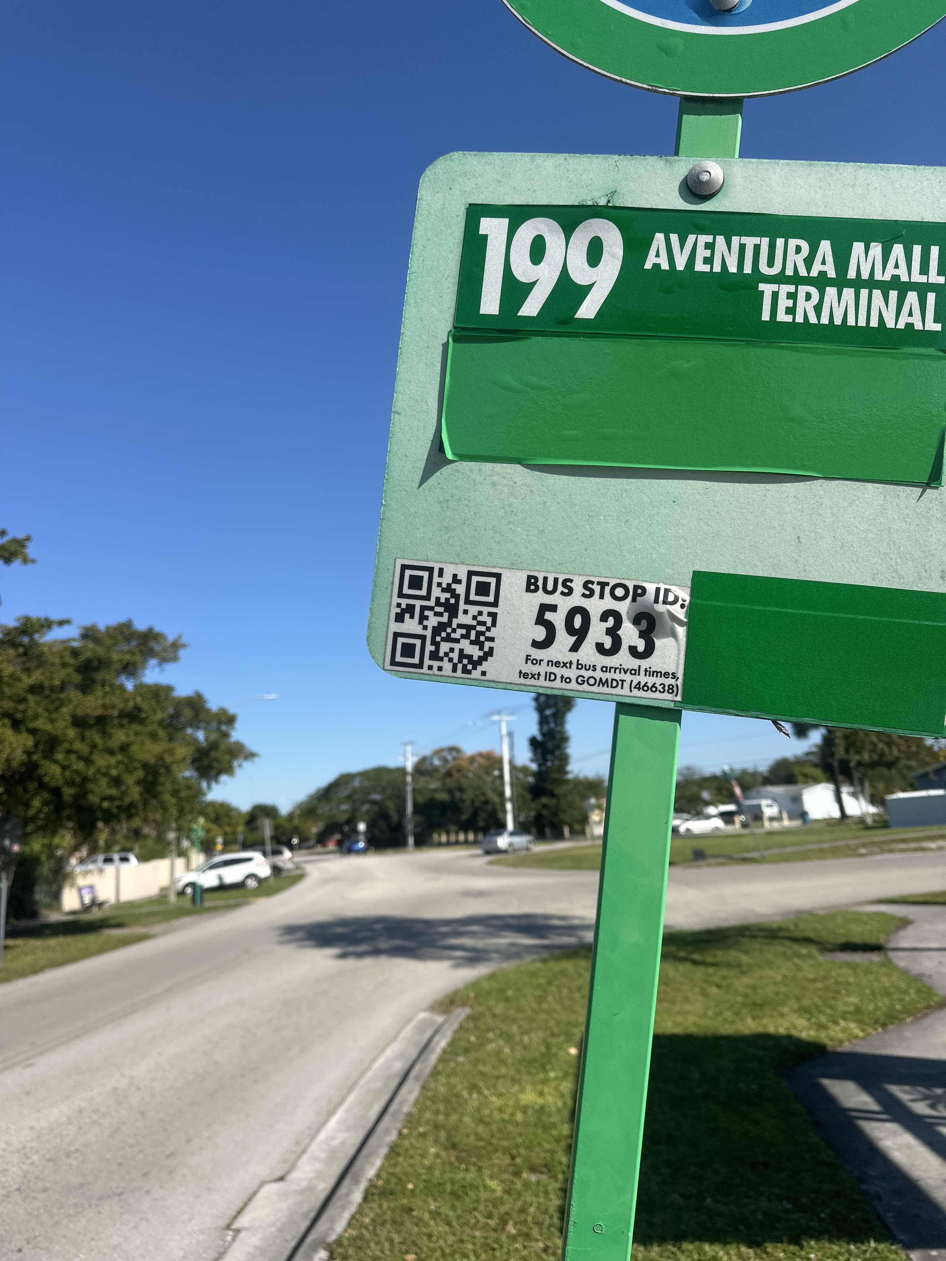 Taken by Anonymous
See Ne 10 Av & Ne 196 Te stop, Miami, on the map
Public transit to Ne 10 Av & Ne 196 Te stop (ID: A10V1961) in Miami
Looking for directions to Ne 10 Av & Ne 196 Te in Miami, United States?
Download the Moovit App to find the current schedule and step-by-step directions for Bus routes that pass through Ne 10 Av & Ne 196 Te.
Looking for the nearest stops closest to Ne 10 Av & Ne 196 Te ? Check out this list of closest stops to your destination: Ne 10 Av & Ne 196 Te; Aventura.
Bus: 199.Train: BLFM.
We make riding on public transit to Ne 10 Av & Ne 196 Te easy, which is why over 1.7 billion users, including users in Miami trust Moovit as the best app for public transit.
Use the app to navigate to popular places including to the airport, hospital, stadium, grocery store, mall, coffee shop, school, college, and university.
Ne 10 Av & Ne 196 Te stop’s code is A10V1961
The first line to this stop is 199, at 5:11 AM, and the last line is 199 at 10:39 PM.
This stop serves Miami-Dade Transit’s lines
- Ne 10 Av & Ne 196 Te
Bus stop near Ne 10 Av & Ne 196 Te stop
- Aventura
Train station near Ne 10 Av & Ne 196 Te station
- Nw 7 St & Nw 57 Av,
- Sunrise Boulevard/Sunset Strip,
- Oakland Park Boulevard/A1A,
- 5 St & Lenox Av,
- JOG RD at WALLIS RD,
- Allapattah Station @ 3501 Nw 12 Av,
- Royal Caribbean@terminal J,
- LINTON BLVD at SIMS RD,
- Brickell,
- Vizcaya,
- W Flagler St & Nw 51 Av,
- Jog Rd at Forest Hill Blvd,
- W Flagler St & Sw 105 Pl,
- Nw 60 Av & Nw 139 St,
- Brickell Mover & Sw 1 Av/11 St,
- Biscayne Blvd & Ne 15 St,
- W Flagler St @ Nw 6 Av,
- Sw 8 St & 42 Av,
- Culmer,
- Sw 87 Av & Sw 41 St
Popular public transit stations in Miami
Get around Miami by public transit!
Traveling around Miami has never been so easy. See step by step directions as you travel to any attraction, street or major public transit station. View bus and train schedules, arrival times, service alerts and detailed routes on a map, so you know exactly how to get to anywhere in Miami.
When traveling to any destination around Miami use Moovit's Live Directions with Get Off Notifications to know exactly where and how far to walk, how long to wait for your line, and how many stops are left. Moovit will alert you when it's time to get off — no need to constantly re-check whether yours is the next stop.
Wondering how to use public transit in Miami or how to pay for public transit in Miami? Moovit public transit app can help you navigate your way with public transit easily, and at minimum cost. It includes public transit fees, ticket prices, and costs. Looking for a map of Miami public transit lines? Moovit public transit app shows all public transit maps in Miami with all Bus, Train, Light Rail and Ferry routes and stops on an interactive map.
Miami has 4 transit type(s), including: Bus, Train, Light Rail and Ferry, operated by several transit agencies, including Broward County Transit, Miami-Dade Transit, Metrorail, Palm Tran, Tri-Rail, Brightline, MARTY, City of Homestead Trolley, Key West Transit, Treasure Coast Connector, GoLine IRT, Amtrak, Greyhound-us, FlixBus-us and Aventura Express Shuttle Bus