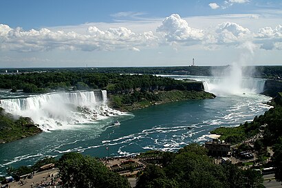
See Niagara Falls on the map
Directions to Niagara Falls with public transportation
The following transit lines have routes that pass near Niagara Falls
 Bus:
Bus: - Train:
How to get to Niagara Falls by bus?
Click on the bus route to see step by step directions with maps, line arrival times and updated time schedules.
How to get to Niagara Falls by train?
Click on the train route to see step by step directions with maps, line arrival times and updated time schedules.
Which bus lines stop near Niagara Falls?
These bus lines stop near Niagara Falls: 102, 12.
Which train line stops near Niagara Falls?
LW
See Niagara Falls on the map
Public Transportation to Niagara Falls
Wondering how to get to Niagara Falls, Canada? Moovit helps you find the best way to get to Niagara Falls with step-by-step directions from the nearest public transit station.
Moovit provides free maps and live directions to help you navigate through your city. View schedules, routes, timetables, and find out how long does it take to get to Niagara Falls in real time.
Bus:Train:
Want to see if there’s another route that gets you there at an earlier time? Moovit helps you find alternative routes or times. Get directions from and directions to Niagara Falls easily from the Moovit App or Website.
We make riding to Niagara Falls easy, which is why over 1.5 million users, including users in Niagara Falls, trust Moovit as the best app for public transit. You don’t need to download an individual bus app or train app, Moovit is your all-in-one transit app that helps you find the best bus time or train time available.
For information on prices of bus and train, costs and ride fares to Niagara Falls, please check the Moovit app.
Use the app to navigate to popular places including to the airport, hospital, stadium, grocery store, mall, coffee shop, school, college, and university.
Location: Niagara Falls, Toronto
Attractions near Niagara Falls
نیاگرا فالز,나이아가라폴스,XLV,Ніагара-Фоллс,Најагара Фолс,ナイアガラフォールズ,尼亚加拉瀑布城,نیاگرا فالز، انٹاریو,نياجارا فولز,Niagara Folsas,Ontario Avenue,Rivers Edge Inn,Trillium Bed & Breakfast,Redwood Bed and Breakfast,Lion's Head Bed & Breakfast,5227 River Road,Simcoe Glass & Aluminum,Stoneleigh Guest House,Accommodations Niagara B & B,Lord Simcoe ApartmentsHow to get to popular attractions in Niagara Falls with public transit
Appleby GO Station, Burlington,The Junction, Toronto,Lawrence Subway Station, Toronto,Cambridge, Ontario, Cambridge,Erin Mills Town Centre, Mississauga,Brampton ON, Brampton,Insomnia Restaurant and Lounge, Toronto,Durham College (Oshawa Campus), Oshawa,Lahore Tikka House, Toronto,GoodLife Fitness Centres, Toronto,University Of Toronto Mississauga Campus, Mississauga,St. Catharines Bus Terminal, St. Catharines,Aldershot VIA/GO Station, Burlington,Mcmaster University, Hamilton,Outlet Collection at Niagara, Niagara-On-The-Lake,Sheppard West Subway Station, Toronto,Cineplex Cinemas Oakville and VIP, Oakville,Yorkdale Shopping Centre, Toronto,Union Station (YBZ), Toronto,RioCan Georgian Mall, BarrieGet around Niagara Falls by public transit!
Traveling around Niagara Falls has never been so easy. See step by step directions as you travel to any attraction, street or major public transit station. View bus and train schedules, arrival times, service alerts and detailed routes on a map, so you know exactly how to get to anywhere in Niagara Falls.
When traveling to any destination around Niagara Falls use Moovit's Live Directions with Get Off Notifications to know exactly where and how far to walk, how long to wait for your line, and how many stops are left. Moovit will alert you when it's time to get off — no need to constantly re-check whether yours is the next stop.
Wondering how to use public transit in Niagara Falls or how to pay for public transit in Niagara Falls? Moovit public transit app can help you navigate your way with public transit easily, and at minimum cost. It includes public transit fees, ticket prices, and costs. Looking for a map of Niagara Falls public transit lines? Moovit public transit app shows all public transit maps in Niagara Falls with all bus or train routes and stops on an interactive map.
Niagara Falls has 2 transit type(s), including: bus or train, operated by several transit agencies, including TTC, TTC Streetcar, Toronto Subway, GO Transit Bus, GO Transit, Amtrak, York Region Transit, Grand River Transit, Guelph Transit, grt, Hamilton Street Railway, MiWay, Brampton Transit, Burlington Transit and Oakville Transit