See North Attleborough Town Center Historic District, Boston, on the map
Directions to North Attleborough Town Center Historic District (Boston) with public transportation
The following transit lines have routes that pass near North Attleborough Town Center Historic District
 Bus:
Bus:
How to get to North Attleborough Town Center Historic District by bus?
Click on the bus route to see step by step directions with maps, line arrival times and updated time schedules.
Bus stations near North Attleborough Town Center Historic District in Boston
- North Hub,3 min walk,
Bus lines to North Attleborough Town Center Historic District in Boston
- 10,Attleboro/N. Attleborough,
- 11,South Attleboro Connector,
- 14,North Attleborough/Plainville,
What are the closest stations to North Attleborough Town Center Historic District?
The closest stations to North Attleborough Town Center Historic District are:
- North Hub is 162 yards away, 3 min walk.
Which bus line stops near North Attleborough Town Center Historic District?
10
What’s the nearest bus stop to North Attleborough Town Center Historic District in Boston?
The nearest bus stop to North Attleborough Town Center Historic District in Boston is North Hub. It’s a 3 min walk away.
How much is the bus fare to North Attleborough Town Center Historic District?
The bus fare to North Attleborough Town Center Historic District costs about $1.50.
How much is the train fare to North Attleborough Town Center Historic District?
The train fare to North Attleborough Town Center Historic District costs about $2.40 - $12.25.
See North Attleborough Town Center Historic District, Boston, on the map
Public Transit to North Attleborough Town Center Historic District in Boston
Wondering how to get to North Attleborough Town Center Historic District in Boston, United States? Moovit helps you find the best way to get to North Attleborough Town Center Historic District with step-by-step directions from the nearest public transit station.
Moovit provides free maps and live directions to help you navigate through your city. View schedules, routes, timetables, and find out how long does it take to get to North Attleborough Town Center Historic District in real time.
Looking for the nearest stop or station to North Attleborough Town Center Historic District? Check out this list of stops closest to your destination: North Hub.
Bus:
Want to see if there’s another route that gets you there at an earlier time? Moovit helps you find alternative routes or times. Get directions from and directions to North Attleborough Town Center Historic District easily from the Moovit App or Website.
We make riding to North Attleborough Town Center Historic District easy, which is why over 1.5 million users, including users in Boston, trust Moovit as the best app for public transit. You don’t need to download an individual bus app or train app, Moovit is your all-in-one transit app that helps you find the best bus time or train time available.
For information on prices of bus and train, costs and ride fares to North Attleborough Town Center Historic District, please check the Moovit app.
Use the app to navigate to popular places including to the airport, hospital, stadium, grocery store, mall, coffee shop, school, college, and university.
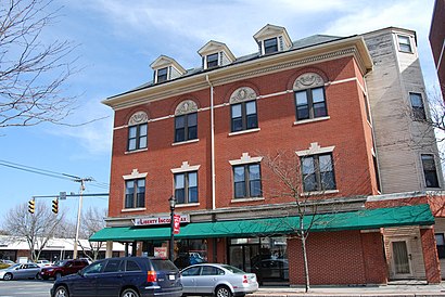
North Attleborough Town Center Historic District Address: Church St North Attleboro, MA 02760 street in Boston
Attractions near North Attleborough Town Center Historic District
North Attleboro,North Attleborough,Clapp Stephen D,Tasha L Buzzell,Del Vecchio Danl,Lorincz Law Office,Boston's Best SAT Tutor,Atm,My Technology Specialist,Ezd Foundation,Foxboro Town & Country Apartments,Tiny Tumbler Gymnastics,Goddess Boxing,Torch'd Kickboxing and Fitness Center,Preservation Framer,Stitch New England,Socks Etc,Donald Siegel - Mortgage Loan Officer,Hospitality Goddess,Healthy Green FlamingoHow to get to popular attractions in Boston with public transit
Barrington, RI,Five Horses Tavern, Somerville,Lolita Cocina & Tequila Bar, Boston,Stephanie's On Newbury, Boston,Kings Dining & Entertainment - Boston Back Bay, Boston,Lincoln Tavern & Restaurant, Boston,BonChon Chicken, Boston,Charlestown, Boston,FiRE + iCE Boston, Boston,Clerys, Boston,Brown University,MBTA Commuter Rail South Attleboro, Attleboro,Southbridge, MA, Southbridge Town,Douzo, Boston,Newton, MA, Newton,Starbucks,Dorchester, Boston,North Shore Mall, Peabody,Cafeteria Boston, Boston,Milford, MA, MilfordGet around Boston by public transit!
Traveling around Boston has never been so easy. See step by step directions as you travel to any attraction, street or major public transit station. View bus and train schedules, arrival times, service alerts and detailed routes on a map, so you know exactly how to get to anywhere in Boston.
When traveling to any destination around Boston use Moovit's Live Directions with Get Off Notifications to know exactly where and how far to walk, how long to wait for your line, and how many stops are left. Moovit will alert you when it's time to get off — no need to constantly re-check whether yours is the next stop.
Wondering how to use public transit in Boston or how to pay for public transit in Boston? Moovit public transit app can help you navigate your way with public transit easily, and at minimum cost. It includes public transit fees, ticket prices, and costs. Looking for a map of Boston public transit lines? Moovit public transit app shows all public transit maps in Boston with all bus or train routes and stops on an interactive map.
Boston has 2 transit type(s), including: bus or train, operated by several transit agencies, including MBTA, MBTA, MBTA, Southeastern Regional Transit Authority, MetroWest Regional Transit Authority, Rhode Island Public Transit Authority, WRTA, Lowell Regional Transit Authority, Merrimack Valley Transit, Montachusett Regional Transit Authority, Cape Cod Regional Transit Authority, Brockton Area Transit Authority, Cape Cod Regional Transit Authority, Martha's Vineyard Transit Authority and the WAVE - Nantucket Regional Transit Authority