Directions to Number 1 Arlington with public transportation
The following transit lines have routes that pass near Number 1 Arlington
 Bus: 350, 77, 83, 87.
- Train: LOWELL.
- Subway: RED LINE, GREEN LINE B, GREEN LINE C, GREEN LINE E.
How to get to Number 1 Arlington by bus?
Click on the bus route to see step by step directions with maps, line arrival times and updated time schedules.
From Bistro du Midi
55 minFrom Courtyard Boston Downtown / Tremont
57 minFrom Lahey Hospital & Medical Center
26 minFrom Back Bay Station
55 minFrom Eliot Hotel
39 minFrom Mass General Waltham
138 minFrom Jamaica Pond
75 minFrom Registry of Motor Vehicles Haymarket (Boston)
65 minFrom Massachusetts General Hospital
139 minFrom Downeast Cider
95 min
How to get to Number 1 Arlington by train?
Click on the train route to see step by step directions with maps, line arrival times and updated time schedules.
How to get to Number 1 Arlington by subway?
Click on the subway route to see step by step directions with maps, line arrival times and updated time schedules.
Bus stops near Number 1 Arlington
Train station near Number 1 Arlington
- West Medford, 2 min walk,VIEW
Subway stations near Number 1 Arlington
What are the closest stations to Number 1 Arlington?
The closest stations to Number 1 Arlington are:
- Massachusetts Ave @ Thorndike St is 80 yards away, 1 min walk.
- West Medford is 97 yards away, 2 min walk.
- Ball Square Station is 434 yards away, 6 min walk.
- Broadway @ N Union St is 500 yards away, 6 min walk.
- Davis Sq. is 981 yards away, 12 min walk.
Which bus lines stop near Number 1 Arlington?
These bus lines stop near Number 1 Arlington: 350, 77, 83.
Which train line stops near Number 1 Arlington?
LOWELL (#327 | Lowell)
Which subway line stops near Number 1 Arlington?
RED LINE (Alewife)
What’s the nearest subway station to Number 1 Arlington?
The nearest subway station to Number 1 Arlington is Ball Square Station. It’s a 6 min walk away.
What’s the nearest train station to Number 1 Arlington?
The nearest train station to Number 1 Arlington is West Medford. It’s a 2 min walk away.
What’s the nearest bus station to Number 1 Arlington?
The nearest bus station to Number 1 Arlington is Massachusetts Ave @ Thorndike St. It’s a 1 min walk away.
What time is the first subway to Number 1 Arlington?
The GREEN LINE E is the first subway that goes to Number 1 Arlington. It stops nearby at 4:55 AM.
What time is the last subway to Number 1 Arlington?
The GREEN LINE E is the last subway that goes to Number 1 Arlington. It stops nearby at 2:41 AM.
What time is the first train to Number 1 Arlington?
The LOWELL is the first train that goes to Number 1 Arlington. It stops nearby at 5:31 AM.
What time is the last train to Number 1 Arlington?
The LOWELL is the last train that goes to Number 1 Arlington. It stops nearby at 12:20 AM.
What time is the first bus to Number 1 Arlington?
The 77 is the first bus that goes to Number 1 Arlington. It stops nearby at 4:56 AM.
What time is the last bus to Number 1 Arlington?
The 87 is the last bus that goes to Number 1 Arlington. It stops nearby at 1:40 AM.
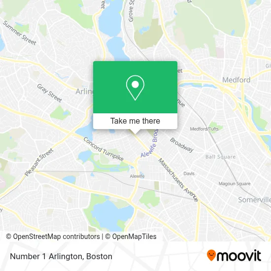
See Number 1 Arlington on the map
Public Transportation to Number 1 Arlington
Wondering how to get to Number 1 Arlington? Moovit helps you find the best way to get to Number 1 Arlington with step-by-step directions from the nearest public transit station.
Moovit provides free maps and live directions to help you navigate through your city. View schedules, routes, timetables, and find out how long does it take to get to Number 1 Arlington in real time.
Looking for the nearest stop or station to Number 1 Arlington? Check out this list of stops closest to your destination: Massachusetts Ave @ Thorndike St; West Medford; Ball Square Station; Broadway @ N Union St; Davis Sq..
Bus: 350, 77, 83, 87.Train: LOWELL.Subway: RED LINE, GREEN LINE B, GREEN LINE C, GREEN LINE E.
Want to see if there’s another route that gets you there at an earlier time? Moovit helps you find alternative routes or times. Get directions from and directions to Number 1 Arlington easily from the Moovit App or Website.
We make riding to Number 1 Arlington easy, which is why over 1.7 million users, including users in Arlington, trust Moovit as the best app for public transit. You don’t need to download an individual bus app or train app, Moovit is your all-in-one transit app that helps you find the best bus time or train time available.
For information on prices of bus, subway and train, costs and ride fares to Number 1 Arlington, please check the Moovit app.
Use the app to navigate to popular places including to the airport, hospital, stadium, grocery store, mall, coffee shop, school, college, and university.
Number 1 Arlington Address: 165 Massachusetts Ave street in Arlington
- Mls Property Information Network, Inc.,
- Metro by T-Mobile,
- Namaste Spice,
- Laundry Delivery Express,
- Glenn S Rothfeld,
- Quilo's Taqueria,
- Support the Fox Library,
- A D T Security Services,
- Salon Foomin (Miami Hair Salon),
- The Fat Greek,
- Toughbuild Masonry and Construction,
- Capitol Theatre,
- Capitol Theatre (Capitol Theater Building),
- Fei Theatres,
- Arlington Locksmith PRO,
- Derby Farm Flowers,
- Your Eco Source ,
- Tpo Painting and Construction,
- Greening-Industry Network,
- Prime Plumbing
Places Near Number 1 Arlington
- Castle Island, Boston,
- Isabella Stewart Gardner Museum, Boston,
- Td Garden, Boston,
- Wilbur Theatre, Boston,
- Boston Common, Boston,
- Wang Theater, Boston,
- Faneuil Hall, Boston,
- Museum Of Science, Boston,
- Seaport District, Boston,
- Massachusetts General Hospital, Boston,
- Boston Convention & Exhibition Center, Boston,
- Boston Medical Center, Boston,
- Prudential Center, Boston,
- Leader Bank Pavilion (Leader Bank Pavillion), Boston,
- Quincy Market, Boston,
- North End, Boston,
- House Of Blues, Boston,
- Mgm Music Hall, Boston,
- Cheers, Boston,
- Boston Children's Hospital, Boston
How to get to popular places in Boston with public transit
Get around Arlington by public transit!
Traveling around Arlington has never been so easy. See step by step directions as you travel to any attraction, street or major public transit station. View bus and train schedules, arrival times, service alerts and detailed routes on a map, so you know exactly how to get to anywhere in Arlington.
When traveling to any destination around Arlington use Moovit's Live Directions with Get Off Notifications to know exactly where and how far to walk, how long to wait for your line, and how many stops are left. Moovit will alert you when it's time to get off — no need to constantly re-check whether yours is the next stop.
Wondering how to use public transit in Arlington or how to pay for public transit in Arlington? Moovit public transit app can help you navigate your way with public transit easily, and at minimum cost. It includes public transit fees, ticket prices, and costs. Looking for a map of Arlington public transit lines? Moovit public transit app shows all public transit maps in Arlington with all Bus, Train, Subway and Ferry routes and stops on an interactive map.
Boston has 4 transit type(s), including: Bus, Train, Subway and Ferry, operated by several transit agencies, including MBTA, Southeastern Regional Transit Authority, MetroWest Regional Transit Authority, Rhode Island Public Transit Authority, WRTA, Lowell Regional Transit Authority, Merrimack Valley Transit, Montachusett Regional Transit Authority, Cape Cod Regional Transit Authority, Brockton Area Transit Authority, Martha's Vineyard Transit Authority, the WAVE - Nantucket Regional Transit Authority, GATRA, Cape Ann Transportation Authority and Massport