Parque Santa Rita I Sector (Ak 50 - Cl 31 Sur) stop - Wednesday schedule
| Line | Direction | Time |
|---|---|---|
| 97 | Rincón De Venecia | 5:04 |
| 143 | Compartir | 5:19 |
| G537 | Villa Del Río | 5:26 |
| 579 | El Recreo | 5:27 |
| G506 | Catalina II | 5:30 |
| 56A | Isla Del Sol | 5:31 |
| 97 | Rincón De Venecia | 5:37 |
| 143 | Compartir | 5:49 |
| G537 | Villa Del Río | 5:56 |
| 579 | El Recreo | 5:57 |
| G506 | Catalina II | 6:00 |
| 56A | Isla Del Sol | 6:01 |
| 97 | Rincón De Venecia | 6:07 |
| 143 | Compartir | 6:19 |
| G537 | Villa Del Río | 6:26 |
| 579 | El Recreo | 6:27 |
| G506 | Catalina II | 6:30 |
| 56A | Isla Del Sol | 6:31 |
| 97 | Rincón De Venecia | 6:37 |
| 143 | Compartir | 6:49 |
| G537 | Villa Del Río | 6:56 |
| 579 | El Recreo | 6:57 |
| G506 | Catalina II | 7:00 |
| 56A | Isla Del Sol | 7:01 |
| 97 | Rincón De Venecia | 7:07 |
Directions to Parque Santa Rita I Sector (Ak 50 - Cl 31 Sur) stop (Puente Aranda) with public transit
The following transit lines have routes that pass near Parque Santa Rita I Sector (Ak 50 - Cl 31 Sur)
How to get to Parque Santa Rita I Sector (Ak 50 - Cl 31 Sur) stop by bus?
Click on the bus route to see step by step directions with maps, line arrival times and updated time schedules.
How to get to Parque Santa Rita I Sector (Ak 50 - Cl 31 Sur) stop by cable car?
Click on the cable car route to see step by step directions with maps, line arrival times and updated time schedules.
Cable Car stations near Parque Santa Rita I Sector (Ak 50 - Cl 31 Sur) station in Puente Aranda
- NQS - Calle 30 Sur, 1 min walk,
- NQS - Calle 38a Sur, 10 min walk,
- General Santander, 17 min walk,
Bus stops near Parque Santa Rita I Sector (Ak 50 - Cl 31 Sur) stop in Puente Aranda
- Urbanización Santa Rita (Ak 50 - Cl 31 Sur), 3 min walk,
- Br. Autopista Sur (Ak 50 - Cl 35 Sur), 4 min walk,
- Br. Autopista Sur (Cl 33 Sur - Kr 50a), 4 min walk,
- Ied Benjamín Herrera (Av. 1 De Mayo - Kr 40b), 7 min walk,
- Ied Benjamín Herrera (Av. 1 De Mayo - Kr 50b) (B), 7 min walk,
- Ied Benjamín Herrera (Av. 1 De Mayo - Kr 51) (A), 7 min walk,
- Br. San Eusebio (Av. 1 De Mayo - Kr 51) (B), 7 min walk,
- Br. San Eusebio (Av. 1 De Mayo - Kr 51) (A), 8 min walk,
- Br. Remanso Sur (Av. 1 De Mayo - Kr 41), 8 min walk,
Bus lines to Parque Santa Rita I Sector (Ak 50 - Cl 31 Sur) stop in Puente Aranda
- A018, Estación Comuneros,
- 56A, Porciúncula,
- 97, Galerías,
- 143, Germania,
- A537, Palermo,
- 579, Marly,
- 97, Rincón De Venecia,
- 143, Compartir,
- G537, Villa Del Río,
- 579, El Recreo,
- A506, Galerías,
- 56A, Isla Del Sol,
- G506, Catalina II,
- T30B, Tihuaque,
- 117, Libertadores,
- 139, Juan Rey,
- L312, Moralba,
- L331, Nueva Delhi,
- L416, La Castaña,
- L508, Estación Avenida 1° De Mayo,
What are the closest stations to Parque Santa Rita I Sector (Ak 50 - Cl 31 Sur)?
The closest stations to Parque Santa Rita I Sector (Ak 50 - Cl 31 Sur) are:
- NQS - Calle 30 Sur is 50 meters away, 1 min walk.
- Urbanización Santa Rita (Ak 50 - Cl 31 Sur) is 228 meters away, 3 min walk.
- Br. Autopista Sur (Ak 50 - Cl 35 Sur) is 248 meters away, 4 min walk.
- Br. Autopista Sur (Cl 33 Sur - Kr 50a) is 268 meters away, 4 min walk.
- Ied Benjamín Herrera (Av. 1 De Mayo - Kr 40b) is 492 meters away, 7 min walk.
- Ied Benjamín Herrera (Av. 1 De Mayo - Kr 50b) (B) is 493 meters away, 7 min walk.
- Ied Benjamín Herrera (Av. 1 De Mayo - Kr 51) (A) is 510 meters away, 7 min walk.
- Br. San Eusebio (Av. 1 De Mayo - Kr 51) (B) is 541 meters away, 7 min walk.
- Br. San Eusebio (Av. 1 De Mayo - Kr 51) (A) is 556 meters away, 8 min walk.
- Br. Remanso Sur (Av. 1 De Mayo - Kr 41) is 583 meters away, 8 min walk.
- NQS - Calle 38a Sur is 775 meters away, 10 min walk.
- General Santander is 1335 meters away, 17 min walk.
Which bus lines stop near Parque Santa Rita I Sector (Ak 50 - Cl 31 Sur)?
These bus lines stop near Parque Santa Rita I Sector (Ak 50 - Cl 31 Sur): 143, 192, 56A, 579, 97, G537, L312.
Which cable car lines stop near Parque Santa Rita I Sector (Ak 50 - Cl 31 Sur)?
These cable car lines stop near Parque Santa Rita I Sector (Ak 50 - Cl 31 Sur): G12, G22, G43, G47.
What’s the nearest bus station to Parque Santa Rita I Sector (Ak 50 - Cl 31 Sur) in Puente Aranda?
The nearest bus station to Parque Santa Rita I Sector (Ak 50 - Cl 31 Sur) in Puente Aranda is Urbanización Santa Rita (Ak 50 - Cl 31 Sur). It’s a 3 min walk away.
What’s the nearest cable car station to Parque Santa Rita I Sector (Ak 50 - Cl 31 Sur) in Puente Aranda?
The nearest cable car station to Parque Santa Rita I Sector (Ak 50 - Cl 31 Sur) in Puente Aranda is NQS - Calle 30 Sur. It’s a 1 min walk away.
What time is the first bus to Parque Santa Rita I Sector (Ak 50 - Cl 31 Sur) in Puente Aranda?
The 12-1 is the first bus that goes to Parque Santa Rita I Sector (Ak 50 - Cl 31 Sur) in Puente Aranda. It stops nearby at 4:00 AM.
What time is the last bus to Parque Santa Rita I Sector (Ak 50 - Cl 31 Sur) in Puente Aranda?
The 12-1 is the last bus that goes to Parque Santa Rita I Sector (Ak 50 - Cl 31 Sur) in Puente Aranda. It stops nearby at 11:30 PM.
What time is the first cable car to Parque Santa Rita I Sector (Ak 50 - Cl 31 Sur) in Puente Aranda?
The B12 is the first cable car that goes to Parque Santa Rita I Sector (Ak 50 - Cl 31 Sur) in Puente Aranda. It stops nearby at 4:05 AM.
What time is the last cable car to Parque Santa Rita I Sector (Ak 50 - Cl 31 Sur) in Puente Aranda?
The 4 is the last cable car that goes to Parque Santa Rita I Sector (Ak 50 - Cl 31 Sur) in Puente Aranda. It stops nearby at 10:45 PM.
Parque Santa Rita I Sector (Ak 50 - Cl 31 Sur) station
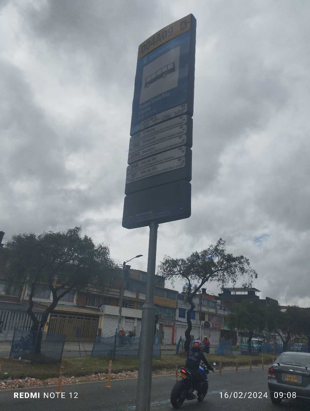 Taken by Anonymous
See Parque Santa Rita I Sector (Ak 50 - Cl 31 Sur) stop, Puente Aranda, on the map
Public transit to Parque Santa Rita I Sector (Ak 50 - Cl 31 Sur) stop (ID: 004A09) in Puente Aranda
Looking for directions to Parque Santa Rita I Sector (Ak 50 - Cl 31 Sur) in Puente Aranda, Colombia?
Download the Moovit App to find the current schedule and step-by-step directions for Bus or Cable Car routes that pass through Parque Santa Rita I Sector (Ak 50 - Cl 31 Sur).
Looking for the nearest stops closest to Parque Santa Rita I Sector (Ak 50 - Cl 31 Sur) ? Check out this list of closest stops to your destination: NQS - Calle 30 Sur; Urbanización Santa Rita (Ak 50 - Cl 31 Sur); Br. Autopista Sur (Ak 50 - Cl 35 Sur); Br. Autopista Sur (Cl 33 Sur - Kr 50a); Ied Benjamín Herrera (Av. 1 De Mayo - Kr 40b); Ied Benjamín Herrera (Av. 1 De Mayo - Kr 50b) (B); Ied Benjamín Herrera (Av. 1 De Mayo - Kr 51) (A); Br. San Eusebio (Av. 1 De Mayo - Kr 51) (B); Br. San Eusebio (Av. 1 De Mayo - Kr 51) (A); Br. Remanso Sur (Av. 1 De Mayo - Kr 41); NQS - Calle 38a Sur; General Santander.
Bus: 143, 192, 56A, 579, 97, G537, L312, A018, A537, A506, G506, C15.Cable Car: G12, G22, G43, G47, 4, 4, B11, G11, G41.
We make riding on public transit to Parque Santa Rita I Sector (Ak 50 - Cl 31 Sur) easy, which is why over 1.5 million users, including users in Puente Aranda trust Moovit as the best app for public transit.
Use the app to navigate to popular places including to the airport, hospital, stadium, grocery store, mall, coffee shop, school, college, and university.
Parque Santa Rita I Sector (Ak 50 - Cl 31 Sur) stop’s code is 004A09
The first line to this stop is 97, at 5:04, and the last line is 56A at 4:59.
36 Ciclovia Av Carrera 50, Colombia
This stop serves TransMiZonal’s lines
Cable Car stations near Parque Santa Rita I Sector (Ak 50 - Cl 31 Sur) station
Bus stops near Parque Santa Rita I Sector (Ak 50 - Cl 31 Sur) stop
Popular public transit stations in Puente Aranda
Get around Puente Aranda by public transit!
Traveling around Puente Aranda has never been so easy. See step by step directions as you travel to any attraction, street or major public transit station. View bus and train schedules, arrival times, service alerts and detailed routes on a map, so you know exactly how to get to anywhere in Puente Aranda.
When traveling to any destination around Puente Aranda use Moovit's Live Directions with Get Off Notifications to know exactly where and how far to walk, how long to wait for your line, and how many stops are left. Moovit will alert you when it's time to get off — no need to constantly re-check whether yours is the next stop.
Wondering how to use public transit in Puente Aranda or how to pay for public transit in Puente Aranda? Moovit public transit app can help you navigate your way with public transit easily, and at minimum cost. It includes public transit fees, ticket prices, and costs. Looking for a map of Puente Aranda public transit lines? Moovit public transit app shows all public transit maps in Puente Aranda with all Bus, Cable Car and Funicular routes and stops on an interactive map.
Bogota has 3 transit type(s), including: Bus, Cable Car and Funicular, operated by several transit agencies, including TransMiZonal, Buses Troncales, TransMiCable, Cerro de Monserrate, Aeropuerto El Dorado, Cootranscajicá Ltda., Flota Chia Ltda. and Auto Servicio Chía Ltda.