Directions to Pico (Arlington) with public transportation
The following transit lines have routes that pass near Pico
 Bus: 77, 67.
- Train: FITCHBURG, LOWELL.
- Subway: RED LINE, GREEN LINE B, GREEN LINE C, GREEN LINE E.
How to get to Pico by bus?
Click on the bus route to see step by step directions with maps, line arrival times and updated time schedules.
From Prudential Center South Garden, Boston
53 minFrom Lahey Hospital & Medical Center, Burlington
25 minFrom Assembly Row, Somerville
36 minFrom Beth Israel Hospital, Boston
66 minFrom The Mapparium, Boston
46 minFrom Prudential Center, Boston
54 minFrom Beth Israel Deaconess Medical Center, Brookline
69 minFrom Brighton District Court, Boston
52 minFrom North End, Boston
55 minFrom Four Seasons Hotel One Dalton, Boston
50 min
How to get to Pico by train?
Click on the train route to see step by step directions with maps, line arrival times and updated time schedules.
How to get to Pico by subway?
Click on the subway route to see step by step directions with maps, line arrival times and updated time schedules.
From Prudential Center South Garden, Boston
80 minFrom Assembly Row, Somerville
69 minFrom Beth Israel Hospital, Boston
94 minFrom The Mapparium, Boston
81 minFrom Prudential Center, Boston
79 minFrom Beth Israel Deaconess Medical Center, Brookline
91 minFrom Brighton District Court, Boston
118 minFrom North End, Boston
75 minFrom Four Seasons Hotel One Dalton, Boston
81 min
Bus stop near Pico in Arlington
- Massachusetts Ave @ Academy St, 1 min walk,VIEW
Subway stations near Pico in Arlington
What are the closest stations to Pico?
The closest stations to Pico are:
- Massachusetts Ave @ Academy St is 42 yards away, 1 min walk.
- Belmont is 2291 yards away, 27 min walk.
- West Medford is 3142 yards away, 37 min walk.
- Alewife is 4234 yards away, 50 min walk.
- Medford/Tufts Station is 4355 yards away, 52 min walk.
Which bus line stops near Pico?
77 (Arlington Heights)
Which train lines stop near Pico?
These train lines stop near Pico: FITCHBURG, LOWELL.
Which subway line stops near Pico?
RED LINE (Alewife)
What’s the nearest train station to Pico in Arlington?
The nearest train station to Pico in Arlington is Belmont. It’s a 27 min walk away.
What’s the nearest bus station to Pico in Arlington?
The nearest bus station to Pico in Arlington is Massachusetts Ave @ Academy St. It’s a 1 min walk away.
What time is the first subway to Pico in Arlington?
The GREEN LINE E is the first subway that goes to Pico in Arlington. It stops nearby at 4:57 AM.
What time is the last subway to Pico in Arlington?
The GREEN LINE E is the last subway that goes to Pico in Arlington. It stops nearby at 2:41 AM.
What time is the first train to Pico in Arlington?
The LOWELL is the first train that goes to Pico in Arlington. It stops nearby at 5:29 AM.
What time is the last train to Pico in Arlington?
The LOWELL is the last train that goes to Pico in Arlington. It stops nearby at 12:20 AM.
What time is the first bus to Pico in Arlington?
The 77 is the first bus that goes to Pico in Arlington. It stops nearby at 4:52 AM.
What time is the last bus to Pico in Arlington?
The 77 is the last bus that goes to Pico in Arlington. It stops nearby at 1:24 AM.
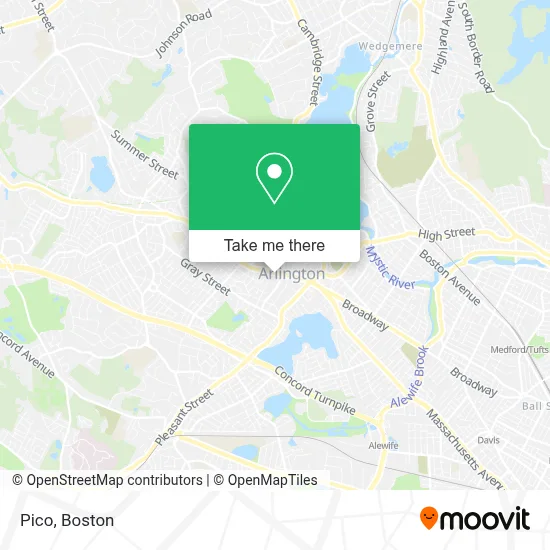
See Pico, Arlington, on the map
Public Transit to Pico in Arlington
Wondering how to get to Pico in Arlington? Moovit helps you find the best way to get to Pico with step-by-step directions from the nearest public transit station.
Moovit provides free maps and live directions to help you navigate through your city. View schedules, routes, timetables, and find out how long does it take to get to Pico in real time.
Looking for the nearest stop or station to Pico? Check out this list of stops closest to your destination: Massachusetts Ave @ Academy St; Belmont; West Medford; Alewife; Medford/Tufts Station.
Bus: 77, 67.Train: FITCHBURG, LOWELL.Subway: RED LINE, GREEN LINE B, GREEN LINE C, GREEN LINE E.
Want to see if there’s another route that gets you there at an earlier time? Moovit helps you find alternative routes or times. Get directions from and directions to Pico easily from the Moovit App or Website.
We make riding to Pico easy, which is why over 1.7 million users, including users in Arlington, trust Moovit as the best app for public transit. You don’t need to download an individual bus app or train app, Moovit is your all-in-one transit app that helps you find the best bus time or train time available.
For information on prices of bus, subway and train, costs and ride fares to Pico, please check the Moovit app.
Use the app to navigate to popular places including to the airport, hospital, stadium, grocery store, mall, coffee shop, school, college, and university.
Pico Address: 808 Massachusetts Ave street in Arlington
- Amazon Counter at Whole Foods Market,
- Whole Foods Market-Arlington Center,
- Amazon Locker-Arlington,
- Alta Coffee Roasters,
- Tayloring and Alteration by Janette,
- Chiropractic Sciatica,
- Body Tune,
- Otaku Gifts Shop,
- A T B Travel Network,
- Wild Ember,
- Joe's Barber Shop,
- Atwood House,
- Locksmith Professionals,
- Drikung Meditation Center,
- Jonesys Appliance Service,
- Edward Jones Investments,
- Metrocreate,
- Mill Cafe,
- Ann M Morvai,
- Sivon Irvings, LCSW
Places Near Pico (Arlington)
- Boston Common, Boston,
- Isabella Stewart Gardner Museum, Boston,
- North End, Boston,
- Boston Medical Center, Boston,
- House Of Blues, Boston,
- Quincy Market, Boston,
- Massachusetts General Hospital, Boston,
- Museum Of Science, Boston,
- Cheers, Boston,
- Td Garden, Boston,
- Faneuil Hall, Boston,
- Castle Island, Boston,
- Boston Convention & Exhibition Center, Boston,
- Leader Bank Pavilion (Leader Bank Pavillion), Boston,
- Boston Children's Hospital, Boston,
- Wilbur Theatre, Boston,
- Seaport District, Boston,
- Prudential Center, Boston,
- Mgm Music Hall, Boston,
- Wang Theater, Boston
How to get to popular places in Boston with public transit
Get around Arlington by public transit!
Traveling around Arlington has never been so easy. See step by step directions as you travel to any attraction, street or major public transit station. View bus and train schedules, arrival times, service alerts and detailed routes on a map, so you know exactly how to get to anywhere in Arlington.
When traveling to any destination around Arlington use Moovit's Live Directions with Get Off Notifications to know exactly where and how far to walk, how long to wait for your line, and how many stops are left. Moovit will alert you when it's time to get off — no need to constantly re-check whether yours is the next stop.
Wondering how to use public transit in Arlington or how to pay for public transit in Arlington? Moovit public transit app can help you navigate your way with public transit easily, and at minimum cost. It includes public transit fees, ticket prices, and costs. Looking for a map of Arlington public transit lines? Moovit public transit app shows all public transit maps in Arlington with all Bus, Train, Subway and Ferry routes and stops on an interactive map.
Boston has 4 transit type(s), including: Bus, Train, Subway and Ferry, operated by several transit agencies, including MBTA, Southeastern Regional Transit Authority, MetroWest Regional Transit Authority, Rhode Island Public Transit Authority, WRTA, Lowell Regional Transit Authority, Merrimack Valley Transit, Montachusett Regional Transit Authority, Cape Cod Regional Transit Authority, Brockton Area Transit Authority, Martha's Vineyard Transit Authority, the WAVE - Nantucket Regional Transit Authority, GATRA, Cape Ann Transportation Authority and Massport