Place D'Italie station - Tuesday schedule
| Line | Direction | Time |
|---|---|---|
| H | Paris Nord | 05:30 |
| H | Creil/ Pontoise/ Persan - Beaumont/ Luzarches | 05:34 |
| H | Creil/ Pontoise/ Persan - Beaumont/ Luzarches | 05:36 |
| H | Paris Nord | 05:38 |
| H | Paris Nord | 05:38 |
| H | Paris Nord | 05:40 |
| H | Creil/ Pontoise/ Persan - Beaumont/ Luzarches | 05:40 |
| H | Paris Nord | 05:45 |
| H | Creil/ Pontoise/ Persan - Beaumont/ Luzarches | 05:46 |
| H | Paris Nord | 05:47 |
| H | Paris Nord | 05:48 |
| H | Paris Nord | 05:48 |
| H | Creil/ Pontoise/ Persan - Beaumont/ Luzarches | 05:51 |
| H | Paris Nord | 05:52 |
| H | Paris Nord | 05:53 |
| H | Paris Nord | 05:55 |
| H | Paris Nord | 05:57 |
| H | Creil/ Pontoise/ Persan - Beaumont/ Luzarches | 05:57 |
| H | Paris Nord | 05:58 |
| 7 | Villejuif-Louis Aragon | 06:00 |
| H | Paris Nord | 06:00 |
| H | Paris Nord | 06:02 |
| H | Creil/ Pontoise/ Persan - Beaumont/ Luzarches | 06:02 |
| H | Paris Nord | 06:03 |
| H | Creil/ Pontoise/ Persan - Beaumont/ Luzarches | 06:03 |
See Place D'Italie, Paris, on the map
Directions to Place D'Italie (Paris) with public transportation
The following transit lines have routes that pass near Place D'Italie
 Metro:
 - Bus:
How to get to Place D'Italie by bus?
Click on the bus route to see step by step directions with maps, line arrival times and updated time schedules.
How to get to Place D'Italie by metro?
Click on the metro route to see step by step directions with maps, line arrival times and updated time schedules.
Bus stations near Place D'Italie in Paris
- Place D'Italie - Choisy,2 min walk,
- Place D'Italie,2 min walk,
- Place D'Italie - Italie 2,2 min walk,
- Place D'Italie - Auriol,2 min walk,
- Place D'Italie - Bobillot,2 min walk,
- Place D'Italie - Mairie du 13e,3 min walk,
Metro stations near Place D'Italie in Paris
- Corvisart,6 min walk,
- Les Gobelins,8 min walk,
- Campo-Formio,8 min walk,
Bus lines to Place D'Italie in Paris
- 64,Denfert-Rochereau,
- 61,Place D'Italie,
- N22,Marché International de Rungis,
- 47,Fort du Kremlin-Bicêtre,
- N15,Villejuif - Louis Aragon,
- 27,Gare Saint-Lazare,
- 83,Sèvres - Babylone,
- N31,La Briqueterie,
- 59,Place D'Italie,
- 57,Laplace RER,
- 67,Palais Royal - Musée du Louvre,
- N139,Gare de Corbeil-Essonnes,
What are the closest stations to Place D'Italie?
The closest stations to Place D'Italie are:
- Place D'Italie - Choisy is 82 meters away, 2 min walk.
- Place D'Italie is 86 meters away, 2 min walk.
- Place D'Italie - Italie 2 is 88 meters away, 2 min walk.
- Place D'Italie - Auriol is 110 meters away, 2 min walk.
- Place D'Italie - Bobillot is 140 meters away, 2 min walk.
- Place D'Italie - Mairie du 13e is 178 meters away, 3 min walk.
- Corvisart is 418 meters away, 6 min walk.
- Les Gobelins is 554 meters away, 8 min walk.
- Campo-Formio is 561 meters away, 8 min walk.
Which metro lines stop near Place D'Italie?
These metro lines stop near Place D'Italie: 5, 6, 7.
Which bus lines stop near Place D'Italie?
These bus lines stop near Place D'Italie: 185, 24, 57, 64, 68, 88.
What’s the nearest metro station to Place D'Italie in Paris?
The nearest metro station to Place D'Italie in Paris is Corvisart. It’s a 6 min walk away.
What’s the nearest bus stop to Place D'Italie in Paris?
The nearest bus stops to Place D'Italie in Paris are Place D'Italie - Choisy, Place D'Italie, Place D'Italie - Italie 2, Place D'Italie - Auriol and Place D'Italie - Bobillot. The closest one is a 2 min walk away.
What time is the first metro to Place D'Italie in Paris?
The 5 is the first metro that goes to Place D'Italie in Paris. It stops nearby at 5:31 AM.
What time is the last metro to Place D'Italie in Paris?
The 5 is the last metro that goes to Place D'Italie in Paris. It stops nearby at 1:13 AM.
What time is the first bus to Place D'Italie in Paris?
The N15 is the first bus that goes to Place D'Italie in Paris. It stops nearby at 3:01 AM.
What time is the last bus to Place D'Italie in Paris?
The N22 is the last bus that goes to Place D'Italie in Paris. It stops nearby at 4:04 AM.
See Place D'Italie, Paris, on the map
Public transit to Place D'Italie station in Paris
Looking for directions to Place D'Italie in Paris, France?
Download the Moovit App to find the current schedule and step-by-step directions for Metro, Bus, RER or Light Rail routes that pass through Place D'Italie.
Looking for the nearest stops closest to Place D'Italie ? Check out this list of closest stops to your destination: Place D'Italie - Choisy; Place D'Italie; Place D'Italie - Italie 2; Place D'Italie - Auriol; Place D'Italie - Bobillot; Place D'Italie - Mairie du 13e; Corvisart; Les Gobelins; Campo-Formio.
Metro:Bus:
We make riding on public transit to Place D'Italie easy, which is why over 1.5 million users, including users in Paris trust Moovit as the best app for public transit.
Use the app to navigate to popular places including to the airport, hospital, stadium, grocery store, mall, coffee shop, school, college, and university.
The station has the following entrances: 2|Centre Commercial Italie 2, 4|Mairie du 13e Manufacture Des Gobelins, 3|Boulevard Vincent Auriol and 1|Boulevard Auguste Blanqui Manufacture Des Gobelins
The first line to this station is H, at 05:30, and the last line is H at 01:15.
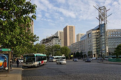
Avenue d'Italie, Paris, France
This station serves Train and RATP’s lines
Popular routes to Place D'Italie, Paris
Popular routes from Place D'Italie, Paris
Bus stops near Place D'Italie
Place D'Italie - Choisy,Place D'Italie,Place D'Italie - Italie 2,Place D'Italie - Auriol,Place D'Italie - Bobillot,Place D'Italie - Mairie du 13ePopular public transit stations in Paris
Sénat,Berry,Federico Garcia Lorca,Couronnes,Ecoles du Petit Colombes,Hôtel de Ville,Palaiseau,Gare de Dourdan,Gare de Chénay Gagny,Épinay - Villetaneuse,Ecole Vétérinaire de Maisons-Alfort,Echangeur de Rosny,Musée du Luxembourg,Bérionne,Gare de Lyon,Hôpital Ambroise Paré,Gare de Dourdan,La Courneuve - 8 Mai 1945,Gretz-Armainvilliers,8 Mai 1945Get around Paris by public transit!
Traveling around Paris has never been so easy. See step by step directions as you travel to any attraction, street or major public transit station. View bus and train schedules, arrival times, service alerts and detailed routes on a map, so you know exactly how to get to anywhere in Paris.
When traveling to any destination around Paris use Moovit's Live Directions with Get Off Notifications to know exactly where and how far to walk, how long to wait for your line, and how many stops are left. Moovit will alert you when it's time to get off — no need to constantly re-check whether yours is the next stop.
Wondering how to use public transit in Paris or how to pay for public transit in Paris? Moovit public transit app can help you navigate your way with public transit easily, and at minimum cost. It includes public transit fees, ticket prices, and costs. Looking for a map of Paris public transit lines? Moovit public transit app shows all public transit maps in Paris with all metro, bus, RER or light rail routes and stops on an interactive map.
Paris has 4 transit type(s), including: metro, bus, RER or light rail, operated by several transit agencies, including RATP, RER, RER Bus de remplacement, Train, Train Bus de remplacement, RATP, Tramway Bus de remplacement, TER, RATP, Tramway, ADP, ADP, RATP, Noctilien and Magical Shuttle