See Portland Aerial Tram, Portland, OR, on the map
Directions to Portland Aerial Tram (Portland, OR) with public transportation
The following transit lines have routes that pass near Portland Aerial Tram
 Bus:
Bus: - Gondola:
How to get to Portland Aerial Tram by bus?
Click on the bus route to see step by step directions with maps, line arrival times and updated time schedules.
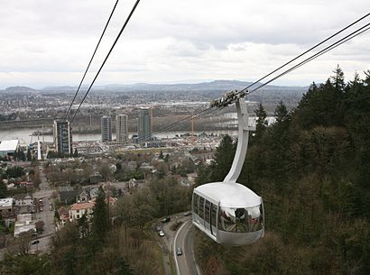
Gondola stations near Portland Aerial Tram in Portland, OR
- South Waterfront Lower Tram Terminal (West),1 min walk,
Bus stations near Portland Aerial Tram in Portland, OR
- Sw Moody & Gibbs (South),1 min walk,
Bus lines to Portland Aerial Tram in Portland, OR
- NS,S Lowell & Bond (East),
- 35,Oregon City Transit Center (West),
- 99,SW 6th & W Burnside (North),
What are the closest stations to Portland Aerial Tram?
The closest stations to Portland Aerial Tram are:
- South Waterfront Lower Tram Terminal (West) is 51 yards away, 1 min walk.
- Sw Moody & Gibbs (South) is 57 yards away, 1 min walk.
Which bus lines stop near Portland Aerial Tram?
These bus lines stop near Portland Aerial Tram: 35, 43.
What’s the nearest bus stop to Portland Aerial Tram in Portland, OR?
The nearest bus stop to Portland Aerial Tram in Portland, OR is Sw Moody & Gibbs (South). It’s a 1 min walk away.
What’s the nearest gondola station to Portland Aerial Tram in Portland, OR?
The nearest gondola station to Portland Aerial Tram in Portland, OR is South Waterfront Lower Tram Terminal (West). It’s a 1 min walk away.
See Portland Aerial Tram, Portland, OR, on the map
Public Transit to Portland Aerial Tram in Portland, OR
Wondering how to get to Portland Aerial Tram in Portland, OR, United States? Moovit helps you find the best way to get to Portland Aerial Tram with step-by-step directions from the nearest public transit station.
Moovit provides free maps and live directions to help you navigate through your city. View schedules, routes, timetables, and find out how long does it take to get to Portland Aerial Tram in real time.
Looking for the nearest stop or station to Portland Aerial Tram? Check out this list of stops closest to your destination: South Waterfront Lower Tram Terminal (West); Sw Moody & Gibbs (South).
Bus:Gondola:
Want to see if there’s another route that gets you there at an earlier time? Moovit helps you find alternative routes or times. Get directions from and directions to Portland Aerial Tram easily from the Moovit App or Website.
We make riding to Portland Aerial Tram easy, which is why over 1.5 million users, including users in Portland, OR, trust Moovit as the best app for public transit. You don’t need to download an individual bus app or train app, Moovit is your all-in-one transit app that helps you find the best bus time or train time available.
For information on prices of bus, costs and ride fares to Portland Aerial Tram, please check the Moovit app.
Use the app to navigate to popular places including to the airport, hospital, stadium, grocery store, mall, coffee shop, school, college, and university.
Portland Aerial Tram Address: 3303 SW Bond Ave street in Portland, OR
Attractions near Portland Aerial Tram
OHSU,3303 SW Bond Ave,Mansi B Parikh MD,OHSU Fertility Consultants,OHSU Neurology,Ohsu Center For Health And Healing,Ohsu Center For Health And Healing,Oregon Health Sciences University Commons,Dermatology - OHSU,March Wellness,Biketown SW Moody at Aerial Tram Terminal,OSU/OHSU College of Pharmacy,Daily Cafe - OHSU,OHSU PT (Out Patient),Smaaken,Daily Cafe,OHSU President's Office,Portland Aerial Tram - Lower Terminal,South Waterfront,Go By BikeHow to get to popular attractions in Portland, OR with public transit
TriMet E 172nd Ave MAX Station, Gresham,Nike - Pete Sampras Building, Beaverton,Saburo's Sushi House, Portland,Johns Landing Neighborhood, Portland,Kaiser Permanente Building, Portland,WinCo Foods, Gresham,Washington Square Mall, Tigard,Fishers Landing, Vancouver,Clackamas County Jail, Oregon City,Trimet South Waterfront / SW Moody MAX Station, Portland,IHOP, Portland,Nike - Jerry Rice Building,Yacolt, WA, Yacolt,Fred Meyer, Raleigh Hills,C-TRAN 99th St Transit Center (Stop 110), Hazel Dell,Tienda La Tapatia, Gresham,Clark College, Vancouver,Clarion Hotel, Portland,Hyatt Place Portland Airport / Cascade Station, Portland,TriMet SE Fuller Rd MAX StationGet around Portland, OR by public transit!
Traveling around Portland, OR has never been so easy. See step by step directions as you travel to any attraction, street or major public transit station. View bus and train schedules, arrival times, service alerts and detailed routes on a map, so you know exactly how to get to anywhere in Portland, OR.
When traveling to any destination around Portland, OR use Moovit's Live Directions with Get Off Notifications to know exactly where and how far to walk, how long to wait for your line, and how many stops are left. Moovit will alert you when it's time to get off — no need to constantly re-check whether yours is the next stop.
Wondering how to use public transit in Portland, OR or how to pay for public transit in Portland, OR? Moovit public transit app can help you navigate your way with public transit easily, and at minimum cost. It includes public transit fees, ticket prices, and costs. Looking for a map of Portland, OR public transit lines? Moovit public transit app shows all public transit maps in Portland, OR with all bus routes and stops on an interactive map.
Portland, OR has 1 transit type(s), including: bus, operated by several transit agencies, including Mount Adams Transportation Service, RiverCities Transit, TriMet , TriMet , TriMet, Portland Streetcar, Portland Aerial Tram, C-TRAN, Multnomah County Job Connector Shuttles, Washington Park Shuttle, SMART, Canby Area Transit, South Clackamas Transportation District, The Wave and Lincoln County Transit