Directions to Questing Tools (Malden) with public transportation
The following transit lines have routes that pass near Questing Tools
 Bus: 101, 104, 99, 105, 106.
- Train: HAVERHILL, NEWBURYPORT/ROCKPORT.
- Subway: ORANGE LINE.
How to get to Questing Tools by bus?
Click on the bus route to see step by step directions with maps, line arrival times and updated time schedules.
From Tufts Medical Center MBTA Station - Orange & Silver Line, Boston
73 minFrom Northeastern University, Boston
102 minFrom Roadrunner, Boston
82 minFrom Spaulding Rehabilitation Center, Boston
83 minFrom Laugh Boston, Boston
65 minFrom Mass Ave, Cambridge
55 minFrom Boston University Goldman School of Dental Medicine, Boston
88 minFrom New Balance, Boston
83 minFrom Revere Beach, Revere
65 minFrom Massachusetts State House, Boston
59 min
How to get to Questing Tools by train?
Click on the train route to see step by step directions with maps, line arrival times and updated time schedules.
How to get to Questing Tools by subway?
Click on the subway route to see step by step directions with maps, line arrival times and updated time schedules.
From Tufts Medical Center MBTA Station - Orange & Silver Line, Boston
28 minFrom Northeastern University, Boston
35 minFrom Roadrunner, Boston
80 minFrom Spaulding Rehabilitation Center, Boston
81 minFrom Laugh Boston, Boston
46 minFrom Mass Ave, Cambridge
46 minFrom Boston University Goldman School of Dental Medicine, Boston
49 minFrom New Balance, Boston
81 minFrom Revere Beach, Revere
63 minFrom Massachusetts State House, Boston
30 min
Bus stops near Questing Tools in Malden
Subway station near Questing Tools in Malden
- Wellington, 31 min walk,VIEW
Bus lines to Questing Tools in Malden
- 99, Wellington - Woodland Rd,VIEW
- 105, Sullivan - Malden,VIEW
- 106, Wellington - Lebanon Loop,VIEW
- 108, Wellington - Linden Square,VIEW
- 131, Malden via Oak Grove - Melrose Highlands via Oak Grove,VIEW
- 137, Malden - Reading Depot,VIEW
- 411, Malden - Jack Satter House,VIEW
- 430, Malden via Square One Mall - Saugus Center via Square One Mall,VIEW
- 104, Malden,VIEW
What are the closest stations to Questing Tools?
The closest stations to Questing Tools are:
- Main St Opp Pleasant St is 68 yards away, 1 min walk.
- Centre St @ Main St is 243 yards away, 4 min walk.
- Wellington is 2643 yards away, 31 min walk.
- Chelsea is 2667 yards away, 34 min walk.
- Oak Grove is 3418 yards away, 41 min walk.
Which bus lines stop near Questing Tools?
These bus lines stop near Questing Tools: 101, 104, 99.
Which train line stops near Questing Tools?
HAVERHILL (#229 | Haverhill)
Which subway line stops near Questing Tools?
ORANGE LINE (Oak Grove)
What’s the nearest bus station to Questing Tools in Malden?
The nearest bus station to Questing Tools in Malden is Main St Opp Pleasant St. It’s a 1 min walk away.
What time is the first subway to Questing Tools in Malden?
The ORANGE LINE is the first subway that goes to Questing Tools in Malden. It stops nearby at 5:15 AM.
What time is the last subway to Questing Tools in Malden?
The ORANGE LINE is the last subway that goes to Questing Tools in Malden. It stops nearby at 1:59 AM.
What time is the first train to Questing Tools in Malden?
The HAVERHILL is the first train that goes to Questing Tools in Malden. It stops nearby at 5:35 AM.
What time is the last train to Questing Tools in Malden?
The NEWBURYPORT/ROCKPORT is the last train that goes to Questing Tools in Malden. It stops nearby at 12:06 AM.
What time is the first bus to Questing Tools in Malden?
The 104 is the first bus that goes to Questing Tools in Malden. It stops nearby at 4:27 AM.
What time is the last bus to Questing Tools in Malden?
The 104 is the last bus that goes to Questing Tools in Malden. It stops nearby at 1:38 AM.
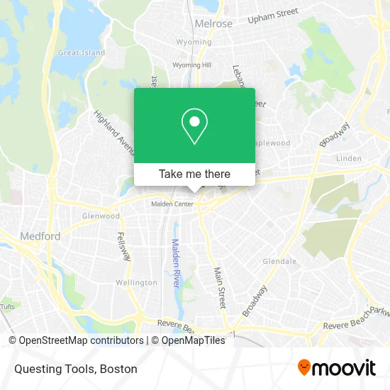
See Questing Tools, Malden, on the map
Public Transit to Questing Tools in Malden
Wondering how to get to Questing Tools in Malden? Moovit helps you find the best way to get to Questing Tools with step-by-step directions from the nearest public transit station.
Moovit provides free maps and live directions to help you navigate through your city. View schedules, routes, timetables, and find out how long does it take to get to Questing Tools in real time.
Looking for the nearest stop or station to Questing Tools? Check out this list of stops closest to your destination: Main St Opp Pleasant St; Centre St @ Main St; Wellington; Chelsea; Oak Grove.
Bus: 101, 104, 99, 105, 106, 108, 131.Train: HAVERHILL, NEWBURYPORT/ROCKPORT.Subway: ORANGE LINE.
Want to see if there’s another route that gets you there at an earlier time? Moovit helps you find alternative routes or times. Get directions from and directions to Questing Tools easily from the Moovit App or Website.
We make riding to Questing Tools easy, which is why over 1.7 million users, including users in Malden, trust Moovit as the best app for public transit. You don’t need to download an individual bus app or train app, Moovit is your all-in-one transit app that helps you find the best bus time or train time available.
For information on prices of subway, bus and train, costs and ride fares to Questing Tools, please check the Moovit app.
Use the app to navigate to popular places including to the airport, hospital, stadium, grocery store, mall, coffee shop, school, college, and university.
Questing Tools Address: 51 Pleasant St street in Malden
- Fairenity Management,
- Pepe's PPS,
- Bethel Church,
- Malden MA Locksmith Store,
- Evcleaning,
- Zuru Zuru Ramen & Donburi,
- Super 99 Century,
- Wireless World Malden,
- Tenoch,
- Boda Borg,
- Beck,
- Darlene Josephs,
- Carlson Management Consulting,
- Glenn Associates,
- Northeastern Remodeling,
- Ax Mortgage,
- Boda Borg Boston,
- Pon de Joy,
- Safy Halal Market,
- Up Tea Hub
Places Near Questing Tools (Malden)
- House Of Blues, Boston,
- Boston Children's Hospital, Boston,
- Leader Bank Pavilion (Leader Bank Pavillion), Boston,
- Prudential Center, Boston,
- North End, Boston,
- Boston Common, Boston,
- Quincy Market, Boston,
- Faneuil Hall, Boston,
- Isabella Stewart Gardner Museum, Boston,
- Wang Theater, Boston,
- Mgm Music Hall, Boston,
- Wilbur Theatre, Boston,
- Cheers, Boston,
- Castle Island, Boston,
- Museum Of Science, Boston,
- Boston Medical Center, Boston,
- Seaport District, Boston,
- Boston Convention & Exhibition Center, Boston,
- Massachusetts General Hospital, Boston,
- Td Garden, Boston
How to get to popular places in Boston with public transit
Get around Malden by public transit!
Traveling around Malden has never been so easy. See step by step directions as you travel to any attraction, street or major public transit station. View bus and train schedules, arrival times, service alerts and detailed routes on a map, so you know exactly how to get to anywhere in Malden.
When traveling to any destination around Malden use Moovit's Live Directions with Get Off Notifications to know exactly where and how far to walk, how long to wait for your line, and how many stops are left. Moovit will alert you when it's time to get off — no need to constantly re-check whether yours is the next stop.
Wondering how to use public transit in Malden or how to pay for public transit in Malden? Moovit public transit app can help you navigate your way with public transit easily, and at minimum cost. It includes public transit fees, ticket prices, and costs. Looking for a map of Malden public transit lines? Moovit public transit app shows all public transit maps in Malden with all Bus, Train, Subway and Ferry routes and stops on an interactive map.
Boston has 4 transit type(s), including: Bus, Train, Subway and Ferry, operated by several transit agencies, including MBTA, Southeastern Regional Transit Authority, MetroWest Regional Transit Authority, Rhode Island Public Transit Authority, WRTA, Lowell Regional Transit Authority, Merrimack Valley Transit, Montachusett Regional Transit Authority, Cape Cod Regional Transit Authority, Brockton Area Transit Authority, Martha's Vineyard Transit Authority, the WAVE - Nantucket Regional Transit Authority, GATRA, Cape Ann Transportation Authority and Massport