See Reforma 222, Azcapotzalco, on the map
Directions to Reforma 222 (Azcapotzalco) with public transportation
The following transit lines have routes that pass near Reforma 222
 Bus:
Bus: - Metro:
How to get to Reforma 222 by bus?
Click on the bus route to see step by step directions with maps, line arrival times and updated time schedules.
How to get to Reforma 222 by metro?
Click on the metro route to see step by step directions with maps, line arrival times and updated time schedules.
Bus stations near Reforma 222 in Azcapotzalco
- Hamburgo L7,3 min walk,
- Metrobús: Hamburgo,3 min walk,
- Hamburgo_1,4 min walk,
- Reforma I,5 min walk,
- Calle Niza 11,5 min walk,
Metro stations near Reforma 222 in Azcapotzalco
- Sevilla,10 min walk,
- Revolución,17 min walk,
- Balderas,21 min walk,
Bus lines to Reforma 222 in Azcapotzalco
- 1,El Caminero - Indios Verdes,
- 2,Glorieta Cuitláhuac Sur - Alameda Tacubaya,
- 7,Hospital Infantil - La Diana,
- L5,La Diana,
- 107,Parque Ceylan,
- 249,Jardin Delegación Azcapotzalco,
- 5,Metro Peñon Viejo,
- RUTA 17,Metro Tacuba,
What are the closest stations to Reforma 222?
The closest stations to Reforma 222 are:
- Hamburgo L7 is 205 meters away, 3 min walk.
- Metrobús: Hamburgo is 211 meters away, 3 min walk.
- Hamburgo_1 is 282 meters away, 4 min walk.
- Reforma I is 317 meters away, 5 min walk.
- Calle Niza 11 is 328 meters away, 5 min walk.
- Sevilla is 764 meters away, 10 min walk.
- Revolución is 1322 meters away, 17 min walk.
- Balderas is 1582 meters away, 21 min walk.
Which bus lines stop near Reforma 222?
These bus lines stop near Reforma 222: 2, 34-A, 7, RUTA 17.
Which metro line stops near Reforma 222?
2
What’s the nearest metro station to Reforma 222 in Azcapotzalco?
The nearest metro station to Reforma 222 in Azcapotzalco is Sevilla. It’s a 10 min walk away.
What’s the nearest bus stop to Reforma 222 in Azcapotzalco?
The nearest bus stops to Reforma 222 in Azcapotzalco are Hamburgo L7 and Metrobús: Hamburgo. The closest one is a 3 min walk away.
What time is the first metro to Reforma 222 in Azcapotzalco?
The 2 is the first metro that goes to Reforma 222 in Azcapotzalco. It stops nearby at 5:20 AM.
What time is the last metro to Reforma 222 in Azcapotzalco?
The 2 is the last metro that goes to Reforma 222 in Azcapotzalco. It stops nearby at 12:35 AM.
What time is the first bus to Reforma 222 in Azcapotzalco?
The 7 is the first bus that goes to Reforma 222 in Azcapotzalco. It stops nearby at 4:21 AM.
What time is the last bus to Reforma 222 in Azcapotzalco?
The 7 is the last bus that goes to Reforma 222 in Azcapotzalco. It stops nearby at 1:05 AM.
How much is the bus fare to Reforma 222?
The bus fare to Reforma 222 costs about $2.00 - $7.50.
See Reforma 222, Azcapotzalco, on the map
Public Transit to Reforma 222 in Azcapotzalco
Wondering how to get to Reforma 222 in Azcapotzalco, México? Moovit helps you find the best way to get to Reforma 222 with step-by-step directions from the nearest public transit station.
Moovit provides free maps and live directions to help you navigate through your city. View schedules, routes, timetables, and find out how long does it take to get to Reforma 222 in real time.
Looking for the nearest stop or station to Reforma 222? Check out this list of stops closest to your destination: Hamburgo L7; Metrobús: Hamburgo; Hamburgo_1; Reforma I; Calle Niza 11; Sevilla; Revolución; Balderas.
Bus:Metro:
Want to see if there’s another route that gets you there at an earlier time? Moovit helps you find alternative routes or times. Get directions from and directions to Reforma 222 easily from the Moovit App or Website.
We make riding to Reforma 222 easy, which is why over 1.5 million users, including users in Azcapotzalco, trust Moovit as the best app for public transit. You don’t need to download an individual bus app or train app, Moovit is your all-in-one transit app that helps you find the best bus time or train time available.
For information on prices of bus and metro, costs and ride fares to Reforma 222, please check the Moovit app.
Use the app to navigate to popular places including to the airport, hospital, stadium, grocery store, mall, coffee shop, school, college, and university.
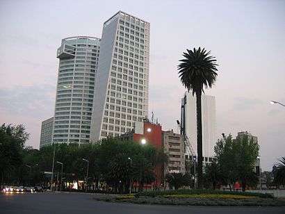
Reforma 222 Address: Av. Paseo de la Reforma 222 street in Azcapotzalco
Attractions near Reforma 222
Reforma 222 Centro Financiero,Paseo de la Reforma 222 Cuauhtemoc Juarez,PASEO DE LA REFORMA 222,McDonalds Reforma,Exposición temporal Snoopy & Charlie Brown,L101 / L102 / TR04,Avenida paseo de la reforma numero 222,Eutelsat Americas,Paseo de la Reforma 222,Chili's Reforma 222,Cinemex,Viaducto (RIO DE LA PIEDAD) 222,Converse (Converse, Reforma 222),Ishop Mixup (Mix Up),Reforma 222,CMR,Havre 7,SAT Centro del D.F,Turibus reforma 222,CMR OficinasHow to get to popular attractions in Azcapotzalco with public transit
Caseta La Venta, Huixquilucan,Corporativo Polanco, Naucalpan De Juárez,Megapantalla IMAX, Naucalpan De Juárez,Puerto Madero, Naucalpan De Juárez,Kimberly-Clark de México, Naucalpan De Juárez,Green Hills School, Cuajimalpa De Morelos,Hospital Multimedica, Atizapán De Zaragoza,El Portón, Naucalpan De Juárez,Six Flags, Alvaro Obregón,Starbucks, Atizapán De Zaragoza,Walmart, Huixquilucan,Chedraui, Coyoacán,Arkana Norte, Cuautitlán Izcalli,Sony Music Mexico, Naucalpan De Juárez,Jardines del Sur, Coyoacán,Loma Linda, Naucalpan De Juárez,SAP México, Naucalpan De Juárez,Nokia Networks México, Huixquilucan,Puentes de Santa Fe, Huixquilucan,Piantao, Alvaro ObregónGet around Azcapotzalco by public transit!
Traveling around Azcapotzalco has never been so easy. See step by step directions as you travel to any attraction, street or major public transit station. View bus and train schedules, arrival times, service alerts and detailed routes on a map, so you know exactly how to get to anywhere in Azcapotzalco.
When traveling to any destination around Azcapotzalco use Moovit's Live Directions with Get Off Notifications to know exactly where and how far to walk, how long to wait for your line, and how many stops are left. Moovit will alert you when it's time to get off — no need to constantly re-check whether yours is the next stop.
Wondering how to use public transit in Azcapotzalco or how to pay for public transit in Azcapotzalco? Moovit public transit app can help you navigate your way with public transit easily, and at minimum cost. It includes public transit fees, ticket prices, and costs. Looking for a map of Azcapotzalco public transit lines? Moovit public transit app shows all public transit maps in Azcapotzalco with all bus or metro routes and stops on an interactive map.
Azcapotzalco has 2 transit type(s), including: bus or metro, operated by several transit agencies, including STC (Metro CDMX), Metrobús, RTP, Trolebús elevado, Trolebús, Tren Ligero, Corredores Concesionados, Ferrocarriles Suburbanos, Mexibus, Mexicable, Cablebús, Puma Bus, Peseros and Autobuses / Combis