See Renage on the map
Directions to Renage with public transportation
The following transit lines have routes that pass near Renage
 Bus:
Bus: - Train:
How to get to Renage by bus?
Click on the bus route to see step by step directions with maps, line arrival times and updated time schedules.
How to get to Renage by train?
Click on the train route to see step by step directions with maps, line arrival times and updated time schedules.
Bus stations near Renage
- Eglise,3 min walk,
- Renage, Eglise,3 min walk,
Train stations near Renage
- Rives,38 min walk,
Bus lines to Renage
- VO11,RIVES MALADIERE VOIRON GARE SUD,
- VO13,RENAGE PL CARDINALE VOIRON GARE SUD,
- VO14,RENAGE PL CARDINALE VOIRON BRAMERET,
- T50,Beaurepaire, Gare Routiere,
What are the closest stations to Renage?
The closest stations to Renage are:
- Eglise is 143 meters away, 3 min walk.
- Renage, Eglise is 154 meters away, 3 min walk.
- Rives is 2892 meters away, 38 min walk.
Which bus line stops near Renage?
T50
Which train lines stop near Renage?
These train lines stop near Renage: C31, C6.
What’s the nearest bus stop to Renage?
The nearest bus stops to Renage are Eglise and Renage, Eglise. The closest one is a 3 min walk away.
What time is the first train to Renage?
The C6 is the first train that goes to Renage. It stops nearby at 5:35 AM.
What time is the last train to Renage?
The C6 is the last train that goes to Renage. It stops nearby at 9:07 PM.
What time is the first bus to Renage?
The T50 is the first bus that goes to Renage. It stops nearby at 6:41 AM.
What time is the last bus to Renage?
The T50 is the last bus that goes to Renage. It stops nearby at 7:05 PM.
How much is the bus fare to Renage?
The bus fare to Renage costs about €1.70.
See Renage on the map
Public Transportation to Renage
Wondering how to get to Renage, France? Moovit helps you find the best way to get to Renage with step-by-step directions from the nearest public transit station.
Moovit provides free maps and live directions to help you navigate through your city. View schedules, routes, timetables, and find out how long does it take to get to Renage in real time.
Looking for the nearest stop or station to Renage? Check out this list of stops closest to your destination: Eglise; Renage, Eglise; Rives.
Bus:Train:
Want to see if there’s another route that gets you there at an earlier time? Moovit helps you find alternative routes or times. Get directions from and directions to Renage easily from the Moovit App or Website.
We make riding to Renage easy, which is why over 1.5 million users, including users in Renage, trust Moovit as the best app for public transit. You don’t need to download an individual bus app or train app, Moovit is your all-in-one transit app that helps you find the best bus time or train time available.
For information on prices of bus and train, costs and ride fares to Renage, please check the Moovit app.
Use the app to navigate to popular places including to the airport, hospital, stadium, grocery store, mall, coffee shop, school, college, and university.
Location: Renage, Grenoble
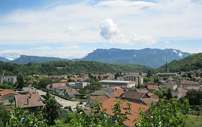
Renage (French pronunciation: [ʁənaʒ]) is a commune in the Isère department in southeastern France.Wiki
Attractions near Renage
Livres à Vous,Paroisse Ste Croix,Isoplac 38,Tc Renage,Renage,Les Branches du Theatre,Les Maisons Rivoises,Sous Toutes L,Le Verdon,Family Food Renage,Union Sportive Renage Rives Rugby,Gc Conception & Rénovation,Lecriture Dun,Union Sportive,Sacpa,Réseau Hb Siege,L'Atelier Paysan,Vival,Rezel Rachid,Roux ClaireHow to get to popular attractions in Renage with public transit
Jardin De Ville, Grenoble,La Belle Électrique, Grenoble,Mont De Lans, Mont-De-Lans,Chambéry, Chambéry,Lrp Montbonnot, Montbonnot-Saint-Martin,Université De Savoie, Chambéry,Porte De France, Grenoble,Lycée Polyvalent Pablo Néruda, Saint-Martin-D'Hères,Caf-Alliés, Grenoble,Les Taillées - Universités, Saint-Martin-D'Hères,Lycée Louise Michel, Grenoble,Mairie de Chambéry, Chambéry,Résidence Le Filaos, Grenoble,Place Hubert Dubedout, Grenoble,Clinique Belledonne, Saint-Martin-D'Hères,INP Grenoble Centre, Grenoble,Meylan, Meylan,Victor Hugo, Grenoble,Montbonnot, Montbonnot-Saint-Martin,Mc2, GrenobleGet around Renage by public transit!
Traveling around Renage has never been so easy. See step by step directions as you travel to any attraction, street or major public transit station. View bus and train schedules, arrival times, service alerts and detailed routes on a map, so you know exactly how to get to anywhere in Renage.
When traveling to any destination around Renage use Moovit's Live Directions with Get Off Notifications to know exactly where and how far to walk, how long to wait for your line, and how many stops are left. Moovit will alert you when it's time to get off — no need to constantly re-check whether yours is the next stop.
Wondering how to use public transit in Renage or how to pay for public transit in Renage? Moovit public transit app can help you navigate your way with public transit easily, and at minimum cost. It includes public transit fees, ticket prices, and costs. Looking for a map of Renage public transit lines? Moovit public transit app shows all public transit maps in Renage with all bus or train routes and stops on an interactive map.
Renage has 2 transit type(s), including: bus or train, operated by several transit agencies, including TAG, TAG, Mobilités M - cars Région, Synchro Bus, Gresi, SNCF VOYAGEURS and capv