See Rockville Railroad Station on the map
Directions to Rockville Railroad Station with public transportation
The following transit lines have routes that pass near Rockville Railroad Station
 Bus:
Bus: - Train:
- Metro:
How to get to Rockville Railroad Station by bus?
Click on the bus route to see step by step directions with maps, line arrival times and updated time schedules.
How to get to Rockville Railroad Station by train?
Click on the train route to see step by step directions with maps, line arrival times and updated time schedules.
How to get to Rockville Railroad Station by metro?
Click on the metro route to see step by step directions with maps, line arrival times and updated time schedules.
Bus stations near Rockville Railroad Station
- Rockville Station & Bay A - West,3 min walk,
- S Stonestreet Ave & Croydon Ave,8 min walk,
Train stations near Rockville Railroad Station
- Rockville,5 min walk,
Bus lines to Rockville Railroad Station
- 46,Medical Center,
- 45,Falls Grove Via Sc,
- 49,Rockville,
- 52,Medstar Montgomery,
What are the closest stations to Rockville Railroad Station?
The closest stations to Rockville Railroad Station are:
- Rockville Station & Bay A - West is 212 yards away, 3 min walk.
- Rockville is 392 yards away, 5 min walk.
- S Stonestreet Ave & Croydon Ave is 605 yards away, 8 min walk.
Which bus lines stop near Rockville Railroad Station?
These bus lines stop near Rockville Railroad Station: 46, Q4, T2.
Which train line stops near Rockville Railroad Station?
MARC
Which metro line stops near Rockville Railroad Station?
METRORAIL RED LINE
What’s the nearest train station to Rockville Railroad Station?
The nearest train station to Rockville Railroad Station is Rockville. It’s a 5 min walk away.
What’s the nearest bus stop to Rockville Railroad Station?
The nearest bus stop to Rockville Railroad Station is Rockville Station & Bay A - West. It’s a 3 min walk away.
See Rockville Railroad Station on the map
Public Transportation to Rockville Railroad Station
Wondering how to get to Rockville Railroad Station, United States? Moovit helps you find the best way to get to Rockville Railroad Station with step-by-step directions from the nearest public transit station.
Moovit provides free maps and live directions to help you navigate through your city. View schedules, routes, timetables, and find out how long does it take to get to Rockville Railroad Station in real time.
Looking for the nearest stop or station to Rockville Railroad Station? Check out this list of stops closest to your destination: Rockville Station & Bay A - West; Rockville; S Stonestreet Ave & Croydon Ave.
Bus:Train:Metro:
Want to see if there’s another route that gets you there at an earlier time? Moovit helps you find alternative routes or times. Get directions from and directions to Rockville Railroad Station easily from the Moovit App or Website.
We make riding to Rockville Railroad Station easy, which is why over 1.5 million users, including users in Rockville, trust Moovit as the best app for public transit. You don’t need to download an individual bus app or train app, Moovit is your all-in-one transit app that helps you find the best bus time or train time available.
For information on prices of bus, metro and train, costs and ride fares to Rockville Railroad Station, please check the Moovit app.
Use the app to navigate to popular places including to the airport, hospital, stadium, grocery store, mall, coffee shop, school, college, and university.
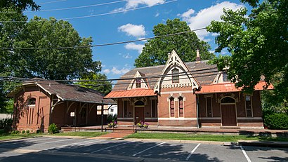
Rockville Railroad Station Address: 98 Church St (at Baltimore Rd.) street in Rockville
Attractions near Rockville Railroad Station
Scoutzz,Krupnikova Nadia,Novick Group,Williams Samantha,Capsicum Group,Saxotech,Smith C Paul,Argan,J Richard Marglies Attorney,RPGR,Gill & Sippel,Maier & Warner PR,8 Church St,Montgomery Business Development,Cofounderslab,DB Capital Management LLC,King Farm Park,BioHealth Innovation,21 Church,Merrill LAD RockvilleHow to get to popular attractions in Rockville with public transit
Lost Society, Washington,Damascus, MD, Montgomery County,The Ugly Mug, Washington,Penn Quarter Sports Tavern, Washington,Arlington Rooftop Bar & Grill, Arlington County,Matchbox Vintage Pizza Bistro, Washington,Toki Underground, Washington,Costco Wholesale, Howard County,Horseshoe Baltimore, Baltimore,Ebenezers Coffeehouse, Washington,Baltimore Farmers' Market & Bazaar, Baltimore,Union Pub, Washington,Bullfeathers, Washington,Green Lantern, Washington,Fogo de Chao, Washington,Little Havana, Baltimore,Agora, Washington,Hank's Oyster Bar, Washington,Hamilton's Bar & Grill, Washington,Honey Pig Gooldaegee Korean Grill, Fairfax CountyGet around Rockville by public transit!
Traveling around Rockville has never been so easy. See step by step directions as you travel to any attraction, street or major public transit station. View bus and train schedules, arrival times, service alerts and detailed routes on a map, so you know exactly how to get to anywhere in Rockville.
When traveling to any destination around Rockville use Moovit's Live Directions with Get Off Notifications to know exactly where and how far to walk, how long to wait for your line, and how many stops are left. Moovit will alert you when it's time to get off — no need to constantly re-check whether yours is the next stop.
Wondering how to use public transit in Rockville or how to pay for public transit in Rockville? Moovit public transit app can help you navigate your way with public transit easily, and at minimum cost. It includes public transit fees, ticket prices, and costs. Looking for a map of Rockville public transit lines? Moovit public transit app shows all public transit maps in Rockville with all bus, metro or train routes and stops on an interactive map.
Rockville has 3 transit type(s), including: bus, metro or train, operated by several transit agencies, including WMATA, WMATA, Montgomery County Ride On, Fairfax Connector, TheBus, DC Circulator, MDOT MTA, Marc, MDOT MTA, MDOT MTA, Virginia Railway Express (VRE), PRTC, DASH - Alexandria, Arlington Transit (ART) and DC Streetcar