How to get to Rue Dieu by bus?
Click on the bus route to see step by step directions with maps, line arrival times and updated time schedules.
From E.Leclerc, Vitry-Sur-Seine
101 minFrom Tour Eiffel, Paris
49 minFrom Salon de l'Agriculture, Paris
65 minFrom Beaugrenelle, Paris
52 minFrom Hôpital Henri Mondor, Creteil
96 minFrom Leroy Merlin, Arrondissement de L'Haÿ-Les-Roses
62 minFrom Suresnes, Suresnes
100 minFrom Paris la Défense Arena, Arrondissement de Nanterre
99 minFrom Musée de l'Air et de l'Espace, Dugny
87 minFrom Paris La Défense Arena, Nanterre
99 min
How to get to Rue Dieu by train?
Click on the train route to see step by step directions with maps, line arrival times and updated time schedules.
How to get to Rue Dieu by metro?
Click on the metro route to see step by step directions with maps, line arrival times and updated time schedules.
From Tour Eiffel, Paris
42 minFrom Salon de l'Agriculture, Paris
40 minFrom Beaugrenelle, Paris
36 minFrom Hôpital Henri Mondor, Creteil
41 minFrom Leroy Merlin, Arrondissement de L'Haÿ-Les-Roses
43 minFrom Paris la Défense Arena, Arrondissement de Nanterre
48 minFrom Paris La Défense Arena, Nanterre
48 min
Bus stops near Rue Dieu in Paris
Metro stations near Rue Dieu in Paris
Bus lines to Rue Dieu in Paris
- 75, Porte de Pantin,VIEW
- 56, Château de Vincennes,VIEW
- 91, Montparnasse 2 - Gare Tgv,VIEW
- 20, Louison Bobet,VIEW
- N02, Gare Montparnasse - Gare Montparnasse,VIEW
- N12, Romainville - Carnot - Pont De Sèvres,VIEW
- N23, Gare De L'est - Gare De Chelles - Gournay Rer,VIEW
- N142, Gare De Tournan - Gare De L'est,VIEW
- N141, Gare de Meaux,VIEW
- 46, Porte Dorée,VIEW
- N01, Barbès - Rochechouart,VIEW
What are the closest stations to Rue Dieu?
The closest stations to Rue Dieu are:
- Alibert is 141 meters away, 2 min walk.
- République - Magenta is 272 meters away, 4 min walk.
- Temple is 296 meters away, 4 min walk.
- République is 336 meters away, 5 min walk.
- Jacques Bonsergent is 414 meters away, 6 min walk.
- Château D'Eau is 690 meters away, 10 min walk.
Which train line stops near Rue Dieu?
H (Paris Nord)
Which metro lines stop near Rue Dieu?
These metro lines stop near Rue Dieu: 11, 3, 5, 8, 9.
Which bus lines stop near Rue Dieu?
These bus lines stop near Rue Dieu: 20, 32, 38, 39, 56, 75, 91.
What’s the nearest metro station to Rue Dieu in Paris?
The nearest metro station to Rue Dieu in Paris is Temple. It’s a 4 min walk away.
What’s the nearest bus station to Rue Dieu in Paris?
The nearest bus station to Rue Dieu in Paris is Alibert. It’s a 2 min walk away.
What time is the first metro to Rue Dieu in Paris?
The 11 is the first metro that goes to Rue Dieu in Paris. It stops nearby at 5:35 AM.
What time is the last metro to Rue Dieu in Paris?
The 11 is the last metro that goes to Rue Dieu in Paris. It stops nearby at 1:10 AM.
What time is the first bus to Rue Dieu in Paris?
The N141 is the first bus that goes to Rue Dieu in Paris. It stops nearby at 3:11 AM.
What time is the last bus to Rue Dieu in Paris?
The N142 is the last bus that goes to Rue Dieu in Paris. It stops nearby at 4:15 AM.
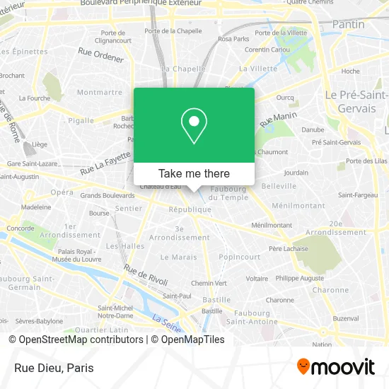
See Rue Dieu, Paris, on the map
Public Transit to Rue Dieu in Paris
Wondering how to get to Rue Dieu in Paris? Moovit helps you find the best way to get to Rue Dieu with step-by-step directions from the nearest public transit station.
Moovit provides free maps and live directions to help you navigate through your city. View schedules, routes, timetables, and find out how long does it take to get to Rue Dieu in real time.
Looking for the nearest stop or station to Rue Dieu? Check out this list of stops closest to your destination: Alibert; République - Magenta; Temple; République; Jacques Bonsergent; Château D'Eau.
Train: H.Metro: 11, 3, 5, 8, 9, 4.Bus: 20, 32, 38, 39, 56, 75, 91.
Want to see if there’s another route that gets you there at an earlier time? Moovit helps you find alternative routes or times. Get directions from and directions to Rue Dieu easily from the Moovit App or Website.
We make riding to Rue Dieu easy, which is why over 1.5 million users, including users in Paris, trust Moovit as the best app for public transit. You don’t need to download an individual bus app or train app, Moovit is your all-in-one transit app that helps you find the best bus time or train time available.
For information on prices of metro, bus, train, RER and light rail, costs and ride fares to Rue Dieu, please check the Moovit app.
Use the app to navigate to popular places including to the airport, hospital, stadium, grocery store, mall, coffee shop, school, college, and university.
Rue Dieu Address: Rue Dieu, 75010 Paris, France street in Paris
- 10 Rue Dieu,
- Mjm Graphic Design,
- 20 Rue Beaurepaire,
- Patricia Blanchet,
- 55Bis Quai de Valmy,
- Basilica of Saint Therese, Lisieux,
- C.S.E. Imagerie Médicale Numérique,
- Rue Yves Toudic,
- Pont Tournant de la Rue Dieu,
- Xilam Animation,
- Canal Saint-Martin,
- Potemkine,
- Alhambra,
- Gros Bao,
- Lycée Bossuet - Notre-Dame,
- Rue Léon Jouhaux,
- Église Saint-Martin-des-Champs,
- La Montgolfière,
- Hotel ibis Styles Paris République Le Marais,
- Chez Prune
Places Near Rue Dieu (Paris)
- Hôpital Beaujon, Clichy,
- Hopital Lariboisière, Paris,
- Institut Curie, Paris,
- Hôpital Cochin, Paris,
- Hôpital Saint-Joseph, Paris,
- Centre Hospitalier des 15/20, Paris,
- Gare Routière Flixbus, Paris,
- Hopital Foch, Suresnes,
- Hôpital Henri Mondor, Creteil,
- Hôpital Pitié Salpêtrière, Paris,
- Créteil Soleil, Creteil,
- Hôpital de la Pitié-Salpêtrière, Paris,
- Théâtre Mogador, Paris,
- 29 Rue Manin, Paris,
- Galeries Lafayette, Paris,
- Galeries Lafayette Haussmann, Paris,
- Atelier Des Lumieres, Paris,
- Hôpital Necker, Paris,
- Marché Saint-Pierre, Paris,
- Fondation Louis Vuitton, Paris
How to get to popular places in Paris with public transit
Get around Paris by public transit!
Traveling around Paris has never been so easy. See step by step directions as you travel to any attraction, street or major public transit station. View bus and train schedules, arrival times, service alerts and detailed routes on a map, so you know exactly how to get to anywhere in Paris.
When traveling to any destination around Paris use Moovit's Live Directions with Get Off Notifications to know exactly where and how far to walk, how long to wait for your line, and how many stops are left. Moovit will alert you when it's time to get off — no need to constantly re-check whether yours is the next stop.
Wondering how to use public transit in Paris or how to pay for public transit in Paris? Moovit public transit app can help you navigate your way with public transit easily, and at minimum cost. It includes public transit fees, ticket prices, and costs. Looking for a map of Paris public transit lines? Moovit public transit app shows all public transit maps in Paris with all Bus, Train, Metro, Light Rail, RER, Funicular and Gondola routes and stops on an interactive map.
Paris has 7 transit type(s), including: Bus, Train, Metro, Light Rail, RER, Funicular and Gondola, operated by several transit agencies, including RATP, RER, RER Bus de remplacement, Train, Train Bus de remplacement, Tramway Bus de remplacement, TER, ADP, Magical Shuttle, Argenteuil - Boucles de Seine, Autocars Dominique, Bièvre, Brie et 2 Morin, Le Bus - C.C. du Clermontois and Cœur d’Essonne