See SE 17th Ave & Holgate Blvd Max Station, Portland, on the map
Directions to SE 17th Ave & Holgate Blvd Max Station (Portland) with public transportation
The following transit lines have routes that pass near SE 17th Ave & Holgate Blvd Max Station
 Bus:
Bus: - Light Rail:
- Streetcar:
How to get to SE 17th Ave & Holgate Blvd Max Station by bus?
Click on the bus route to see step by step directions with maps, line arrival times and updated time schedules.
Bus stations near SE 17th Ave & Holgate Blvd Max Station in Portland
- SE Milwaukie & Mall (North),4 min walk,
- SE 17th & Center (South),5 min walk,
- SE 17th & Rhine (South),10 min walk,
Streetcar stations near SE 17th Ave & Holgate Blvd Max Station in Portland
- S Lowell & Bond (East),11 min walk,
Light Rail stations near SE 17th Ave & Holgate Blvd Max Station in Portland
- SE 17th Ave & Holgate Blvd Max Station,19 min walk,
Bus lines to SE 17th Ave & Holgate Blvd Max Station in Portland
- 19,Flavel & I-205 Overpass (East),
- 70,NE Sunderland & Columbia River Corr Inst (South),
- 17,2500 Block NE Saratoga (West),
- ORANGE,SE Jackson & 21st (East),
What are the closest stations to SE 17th Ave & Holgate Blvd Max Station?
The closest stations to SE 17th Ave & Holgate Blvd Max Station are:
- SE Milwaukie & Mall (North) is 304 yards away, 4 min walk.
- SE 17th & Center (South) is 396 yards away, 5 min walk.
- SE 17th & Rhine (South) is 773 yards away, 10 min walk.
- S Lowell & Bond (East) is 897 yards away, 11 min walk.
- SE 17th Ave & Holgate Blvd Max Station is 1601 yards away, 19 min walk.
Which bus lines stop near SE 17th Ave & Holgate Blvd Max Station?
These bus lines stop near SE 17th Ave & Holgate Blvd Max Station: 17, 70.
Which light rail line stops near SE 17th Ave & Holgate Blvd Max Station?
ORANGE
What’s the nearest light rail station to SE 17th Ave & Holgate Blvd Max Station in Portland?
The nearest light rail station to SE 17th Ave & Holgate Blvd Max Station in Portland is SE 17th Ave & Holgate Blvd Max Station. It’s a 19 min walk away.
What’s the nearest bus stop to SE 17th Ave & Holgate Blvd Max Station in Portland?
The nearest bus stop to SE 17th Ave & Holgate Blvd Max Station in Portland is SE Milwaukie & Mall (North). It’s a 4 min walk away.
What’s the nearest Streetcar station to SE 17th Ave & Holgate Blvd Max Station in Portland?
The nearest Streetcar station to SE 17th Ave & Holgate Blvd Max Station in Portland is S Lowell & Bond (East). It’s a 11 min walk away.
What time is the first light rail to SE 17th Ave & Holgate Blvd Max Station in Portland?
The ORANGE is the first light rail that goes to SE 17th Ave & Holgate Blvd Max Station in Portland. It stops nearby at 4:08 AM.
What time is the last light rail to SE 17th Ave & Holgate Blvd Max Station in Portland?
The ORANGE is the last light rail that goes to SE 17th Ave & Holgate Blvd Max Station in Portland. It stops nearby at 1:11 AM.
What time is the first bus to SE 17th Ave & Holgate Blvd Max Station in Portland?
The 19 is the first bus that goes to SE 17th Ave & Holgate Blvd Max Station in Portland. It stops nearby at 5:05 AM.
What time is the last bus to SE 17th Ave & Holgate Blvd Max Station in Portland?
The ORANGE is the last bus that goes to SE 17th Ave & Holgate Blvd Max Station in Portland. It stops nearby at 1:02 AM.
What time is the first Streetcar to SE 17th Ave & Holgate Blvd Max Station in Portland?
The NS is the first Streetcar that goes to SE 17th Ave & Holgate Blvd Max Station in Portland. It stops nearby at 6:21 AM.
What time is the last Streetcar to SE 17th Ave & Holgate Blvd Max Station in Portland?
The NS is the last Streetcar that goes to SE 17th Ave & Holgate Blvd Max Station in Portland. It stops nearby at 11:26 PM.
See SE 17th Ave & Holgate Blvd Max Station, Portland, on the map
Public Transit to SE 17th Ave & Holgate Blvd Max Station in Portland
Wondering how to get to SE 17th Ave & Holgate Blvd Max Station in Portland, United States? Moovit helps you find the best way to get to SE 17th Ave & Holgate Blvd Max Station with step-by-step directions from the nearest public transit station.
Moovit provides free maps and live directions to help you navigate through your city. View schedules, routes, timetables, and find out how long does it take to get to SE 17th Ave & Holgate Blvd Max Station in real time.
Looking for the nearest stop or station to SE 17th Ave & Holgate Blvd Max Station? Check out this list of stops closest to your destination: SE Milwaukie & Mall (North); SE 17th & Center (South); SE 17th & Rhine (South); S Lowell & Bond (East); SE 17th Ave & Holgate Blvd Max Station.
Bus:Light Rail:Streetcar:
Want to see if there’s another route that gets you there at an earlier time? Moovit helps you find alternative routes or times. Get directions from and directions to SE 17th Ave & Holgate Blvd Max Station easily from the Moovit App or Website.
We make riding to SE 17th Ave & Holgate Blvd Max Station easy, which is why over 1.5 million users, including users in Portland, trust Moovit as the best app for public transit. You don’t need to download an individual bus app or train app, Moovit is your all-in-one transit app that helps you find the best bus time or train time available.
For information on prices of bus and light rail, costs and ride fares to SE 17th Ave & Holgate Blvd Max Station, please check the Moovit app.
Use the app to navigate to popular places including to the airport, hospital, stadium, grocery store, mall, coffee shop, school, college, and university.
SE 17th Ave & Holgate Blvd Max Station Address: 4410 SE 17th Ave street in Portland
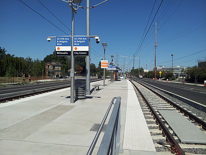
Southeast 17th Avenue and Holgate Boulevard is a MAX Orange Line station located in the median of Southeast 17th Avenue at Holgate Boulevard in the Brooklyn neighborhood of Portland, Oregon.Wiki
Attractions near SE 17th Ave & Holgate Blvd Max Station
TriMet Stop 17th & Holgate,TEI - TriMet fitness center,SE 17th & Mall,SE 18th Ave,ATM,Trimet Center Street Garage,Baha Autobody and Paint (Baha Auto Body & Paint),Murphy Family Electric,Neighborhood Recycling,Clay Factor Ceram,Leeke Architects,Professional Masonry,CF&I,Lynch Company,NE Portland W Portland,Trackers Earth Portland (Trackers Forest School),Trimet Center Street Administrative Offices,Trimet Center Street Administrative Office / Lost And Found,Tiffany Crist -the Lightening Society Salon,TriMet Administrative OfficeHow to get to popular attractions in Portland with public transit
Edith Green-Wendell Wyatt Federal Building, Portland,Moda Center, Portland,Pok Pok Noi, Portland,TriMet Washington / SE 12th Ave MAX Station, Hillsboro,First Tech Federal Credit Union, Portland,WinCo Foods, Gresham,Washington Square Mall, Tigard,Nike - Dan Fouts Building,Sunset Highway US 26W, Portland,Oregon City Transit Center, Oregon City,PSU Urban Center, Portland,TriMet E 181st Ave MAX Station, Gresham,Asian Food Center 百佳超市, Beaverton,McMenamins East Vancouver Pub, Vancouver,Johns Landing Neighborhood, Portland,Kaiser Permanente Building, Portland,Cedar Mill, Beaverton,TriMet SE Fuller Rd MAX Station,TriMet SE Powell Blvd MAX Station, Portland,Clark College, VancouverGet around Portland by public transit!
Traveling around Portland has never been so easy. See step by step directions as you travel to any attraction, street or major public transit station. View bus and train schedules, arrival times, service alerts and detailed routes on a map, so you know exactly how to get to anywhere in Portland.
When traveling to any destination around Portland use Moovit's Live Directions with Get Off Notifications to know exactly where and how far to walk, how long to wait for your line, and how many stops are left. Moovit will alert you when it's time to get off — no need to constantly re-check whether yours is the next stop.
Wondering how to use public transit in Portland or how to pay for public transit in Portland? Moovit public transit app can help you navigate your way with public transit easily, and at minimum cost. It includes public transit fees, ticket prices, and costs. Looking for a map of Portland public transit lines? Moovit public transit app shows all public transit maps in Portland with all bus or light rail routes and stops on an interactive map.
Portland has 2 transit type(s), including: bus or light rail, operated by several transit agencies, including Mount Adams Transportation Service, RiverCities Transit, TriMet , TriMet , TriMet, Portland Streetcar, Portland Aerial Tram, C-TRAN, Multnomah County Job Connector Shuttles, Washington Park Shuttle, SMART, Canby Area Transit, South Clackamas Transportation District, The Wave and Lincoln County Transit