SW 107 ST @ SW 109 CT stop - Sunday schedule
| Line | Direction | Time |
|---|---|---|
| 104 | 104a - Dadeland North Station Via Hammocks Blvd | 6:25 AM |
| 104 | 104a - Dadeland North Station Via Hammocks Blvd | 8:28 AM |
| 104 | 104a - Dadeland North Station Via Hammocks Blvd | 9:38 AM |
| 104 | 104a - Dadeland North Station Via Hammocks Blvd | 10:39 AM |
| 104 | 104a - Dadeland North Station Via Hammocks Blvd | 11:39 AM |
| 104 | 104a - Dadeland North Station Via Hammocks Blvd | 12:39 PM |
| 104 | 104a - Dadeland North Station Via Hammocks Blvd | 1:39 PM |
| 104 | 104a - Dadeland North Station Via Hammocks Blvd | 2:39 PM |
| 104 | 104a - Dadeland North Station Via Hammocks Blvd | 3:39 PM |
| 104 | 104a - Dadeland North Station Via Hammocks Blvd | 4:39 PM |
| 104 | 104a - Dadeland North Station Via Hammocks Blvd | 5:39 PM |
| 104 | 104a - Dadeland North Station Via Hammocks Blvd | 6:38 PM |
| 104 | 104a - Dadeland North Station Via Hammocks Blvd | 7:37 PM |
| 104 | 104a - Dadeland North Station Via Hammocks Blvd | 8:42 PM |
Directions to SW 107 ST @ SW 109 CT stop (Kendall-Palmetto Bay) with public transit
The following transit lines have routes that pass near SW 107 ST @ SW 109 CT
 Bus: 104, 107, 204.
How to get to SW 107 ST @ SW 109 CT stop by bus?
Click on the bus route to see step by step directions with maps, line arrival times and updated time schedules.
Bus stops near SW 107 ST @ SW 109 CT stop in Kendall-Palmetto Bay
- SW 107 ST @ SW 109 CT, 1 min walk,
- SW 107 AV & KENDALE BD, 13 min walk,
- SW 104 ST & SW 108 AV, 28 min walk,
Bus lines to SW 107 ST @ SW 109 CT stop in Kendall-Palmetto Bay
- 104, 104 - Dadeland North Station Via 167 Av,
- 107, 107 - Dolphin Mall Terminal,
- 204, 204 - West Kendall Park & Ride,
What are the closest stations to SW 107 ST @ SW 109 CT?
The closest stations to SW 107 ST @ SW 109 CT are:
- SW 107 ST @ SW 109 CT is 9 yards away, 1 min walk.
- SW 107 AV & KENDALE BD is 1048 yards away, 13 min walk.
- SW 104 ST & SW 108 AV is 2306 yards away, 28 min walk.
Which bus lines stop near SW 107 ST @ SW 109 CT?
These bus lines stop near SW 107 ST @ SW 109 CT: 104, 107, 204.
What’s the nearest bus station to SW 107 ST @ SW 109 CT in Kendall-Palmetto Bay?
The nearest bus station to SW 107 ST @ SW 109 CT in Kendall-Palmetto Bay is SW 107 ST @ SW 109 CT. It’s a 1 min walk away.
What time is the first bus to SW 107 ST @ SW 109 CT in Kendall-Palmetto Bay?
The 104 is the first bus that goes to SW 107 ST @ SW 109 CT in Kendall-Palmetto Bay. It stops nearby at 5:24 AM.
What time is the last bus to SW 107 ST @ SW 109 CT in Kendall-Palmetto Bay?
The 107 is the last bus that goes to SW 107 ST @ SW 109 CT in Kendall-Palmetto Bay. It stops nearby at 12:39 AM.
SW 107 ST @ SW 109 CT station
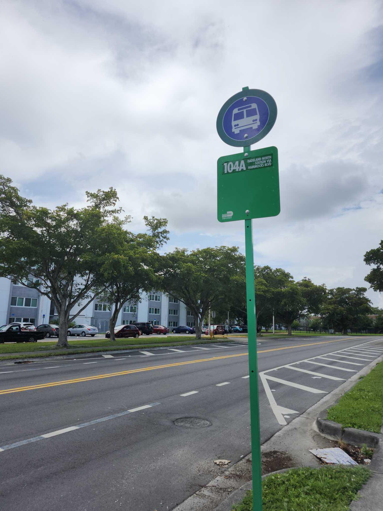 Taken by Roberto G.
See SW 107 ST @ SW 109 CT stop, Kendall-Palmetto Bay, on the map
Public transit to SW 107 ST @ SW 109 CT stop (ID: C1071094) in Kendall-Palmetto Bay
Looking for directions to SW 107 ST @ SW 109 CT in Kendall-Palmetto Bay, United States?
Download the Moovit App to find the current schedule and step-by-step directions for Bus or Train routes that pass through SW 107 ST @ SW 109 CT.
Looking for the nearest stops closest to SW 107 ST @ SW 109 CT ? Check out this list of closest stops to your destination: SW 107 ST @ SW 109 CT; SW 107 AV & KENDALE BD; SW 104 ST & SW 108 AV.
Bus: 104, 107, 204.
We make riding on public transit to SW 107 ST @ SW 109 CT easy, which is why over 1.5 million users, including users in Kendall-Palmetto Bay trust Moovit as the best app for public transit.
Use the app to navigate to popular places including to the airport, hospital, stadium, grocery store, mall, coffee shop, school, college, and university.
SW 107 ST @ SW 109 CT stop’s code is C1071094
The first line to this stop is 104, at 6:25 AM, and the last line is 104 at 8:42 PM.
Southwest 109th Court, Kendall, FL, USA
This stop serves Miami-Dade Transit’s lines
- SW 107 ST @ SW 109 CT,
- SW 107 AV & KENDALE BD,
- SW 104 ST & SW 108 AV
Bus stops near SW 107 ST @ SW 109 CT stop
- BCR TRS at BUS TRM,
- W FLAGLER ST & NW 84 AV,
- SW 8 ST @ SW 129 PL,
- NW 27 AV & OPA LOCKA BD,
- United & Duval St.,
- NW 27 AV & 113 ST,
- LINTON BLVD at BLDG 4675 E ENT,
- WASHINGTON AV & SOUTH POINTE DR,
- NW 107 AV & NW 14 ST,
- FEDERAL HWY at GULFSTREAM BLVD,
- NW 186 ST & 73 AV,
- Kentucky Avenue/Evanston Circle,
- MACARTHUR CY & WATSON ISLAND,
- FOREST HILL BLVD at HAVERHILL RD W,
- Sheridan Street Station,
- TRANSITWAY & SW 328 ST,
- MILE MARKER 98 KEY LARGO,
- LAKE WORTH RD at DAVIS RD,
- NW 199 ST & 2 AV,
- Sunrise Boulevard/Sunset Strip
Popular public transit stations in Kendall-Palmetto Bay
Get around Kendall-Palmetto Bay by public transit!
Traveling around Kendall-Palmetto Bay has never been so easy. See step by step directions as you travel to any attraction, street or major public transit station. View bus and train schedules, arrival times, service alerts and detailed routes on a map, so you know exactly how to get to anywhere in Kendall-Palmetto Bay.
When traveling to any destination around Kendall-Palmetto Bay use Moovit's Live Directions with Get Off Notifications to know exactly where and how far to walk, how long to wait for your line, and how many stops are left. Moovit will alert you when it's time to get off — no need to constantly re-check whether yours is the next stop.
Wondering how to use public transit in Kendall-Palmetto Bay or how to pay for public transit in Kendall-Palmetto Bay? Moovit public transit app can help you navigate your way with public transit easily, and at minimum cost. It includes public transit fees, ticket prices, and costs. Looking for a map of Kendall-Palmetto Bay public transit lines? Moovit public transit app shows all public transit maps in Kendall-Palmetto Bay with all Bus, Train, Light Rail and Ferry routes and stops on an interactive map.
Miami has 4 transit type(s), including: Bus, Train, Light Rail and Ferry, operated by several transit agencies, including Broward County Transit, Miami-Dade Transit, Metrorail, Palm Tran, Tri-Rail, Brightline, MARTY, City of Homestead Trolley, Key West Transit, Treasure Coast Connector, GoLine IRT, Amtrak, Greyhound-us, FlixBus-us and Aventura Express Shuttle Bus