Sacca Fisola "B" station - Saturday schedule
| Line | Direction | Time |
|---|---|---|
| N | Lido S.M.E. D | 03:53 |
| N | P.Le Roma F | 04:53 |
| 2 | P.Le Roma F | 05:16 |
| 2 | P.Le Roma F | 05:36 |
| 2 | Rialto D | 05:56 |
| 2 | Rialto D | 06:16 |
| 4.2 | Riva De Biasio A | 06:26 |
| 2 | Rialto D | 06:36 |
| 4.2 | Riva De Biasio A | 06:46 |
| 2 | Rialto D | 06:48 |
| 2 | Rialto D | 07:00 |
| 4.2 | Riva De Biasio A | 07:06 |
| 2 | Rialto D | 07:12 |
| 2 | Rialto D | 07:24 |
| 4.2 | Riva De Biasio A | 07:26 |
| 2 | Rialto D | 07:36 |
| 4.2 | Riva De Biasio A | 07:46 |
| 2 | Lido S.M.E. E | 07:48 |
| 2 | Lido S.M.E. E | 08:00 |
| 4.2 | Riva De Biasio A | 08:06 |
| 2 | Lido S.M.E. E | 08:12 |
| 2 | Lido S.M.E. E | 08:24 |
| 4.2 | Riva De Biasio A | 08:26 |
| 2 | Lido S.M.E. E | 08:36 |
| 4.2 | Riva De Biasio A | 08:46 |
Directions to Sacca Fisola "B" (Venice) with public transportation
The following transit lines have routes that pass near Sacca Fisola "B"
Ferry stations near Sacca Fisola "B" in Venice
- Sacca Fisola "A",2 min walk,
- Giudecca Hilton,9 min walk,
What are the closest stations to Sacca Fisola "B"?
The closest stations to Sacca Fisola "B" are:
- Sacca Fisola "A" is 91 meters away, 2 min walk.
- Giudecca Hilton is 635 meters away, 9 min walk.
Which ferry lines stop near Sacca Fisola "B"?
These ferry lines stop near Sacca Fisola "B": 2, 4.1, 4.2.
What’s the nearest ferry station to Sacca Fisola "B" in Venice?
The nearest ferry station to Sacca Fisola "B" in Venice is Sacca Fisola "A". It’s a 2 min walk away.
What time is the first ferry to Sacca Fisola "B" in Venice?
The N is the first ferry that goes to Sacca Fisola "B" in Venice. It stops nearby at 3:06 AM.
What time is the last ferry to Sacca Fisola "B" in Venice?
The N is the last ferry that goes to Sacca Fisola "B" in Venice. It stops nearby at 3:14 AM.
See Sacca Fisola "B", Venice, on the map
Public transit to Sacca Fisola "B" station (ID: 5139) in Venice
Looking for directions to Sacca Fisola "B" in Venice, Italy?
Download the Moovit App to find the current schedule and step-by-step directions for Ferry, Bus, Light Rail or Train routes that pass through Sacca Fisola "B".
Looking for the nearest stops closest to Sacca Fisola "B" ? Check out this list of closest stops to your destination: Sacca Fisola "A"; Giudecca Hilton.
Ferry:24.14.2N8B
We make riding on public transit to Sacca Fisola "B" easy, which is why over 1.5 million users, including users in Venice trust Moovit as the best app for public transit.
Use the app to navigate to popular places including to the airport, hospital, stadium, grocery store, mall, coffee shop, school, college, and university.
Sacca Fisola "B" station’s code is 5139
The first line to this station is N, at 03:53, and the last line is N at 02:53.
This station serves ACTV’s lines
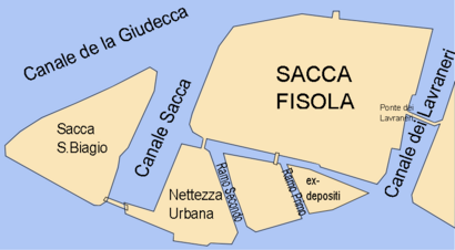
Sacca Fisola is an artificial island in the Venetian Lagoon. It is a largely modern residential area.Wiki
Popular public transit stations in Venice
Dolo Ca' Tron,Ca' Sabbioni Padana,Colle Umberto - Via Kennedy,Badoere,San Donà - Hotel Trieste,Bandiera Durando,Sottomarina Vespucci,FS Duca D'Aosta,Terraglio Terraglietto,Fossalta Di Pieve,S. Chiara "Dogana",Mestre - Cavalcavia,Ca' Savio - Via Fausta,Gaggio Cimitero,San Dona' Rielta,Beccaria Canetti,Gallo Sant'Antonio,Torre Belfredo - Incr. Via Terraglio,Asseggiano Volta,Sambughe'Get around Venice by public transit!
Traveling around Venice has never been so easy. See step by step directions as you travel to any attraction, street or major public transit station. View bus and train schedules, arrival times, service alerts and detailed routes on a map, so you know exactly how to get to anywhere in Venice.
When traveling to any destination around Venice use Moovit's Live Directions with Get Off Notifications to know exactly where and how far to walk, how long to wait for your line, and how many stops are left. Moovit will alert you when it's time to get off — no need to constantly re-check whether yours is the next stop.
Wondering how to use public transit in Venice or how to pay for public transit in Venice? Moovit public transit app can help you navigate your way with public transit easily, and at minimum cost. It includes public transit fees, ticket prices, and costs. Looking for a map of Venice public transit lines? Moovit public transit app shows all public transit maps in Venice with all ferry, bus, light rail or train routes and stops on an interactive map.
Venice has 4 transit type(s), including: ferry, bus, light rail or train, operated by several transit agencies, including ACTV, ACTV, ACTV, Alilaguna S.p.A., Mobilità di Marca, ATVO, Trenitalia and Sistemi Territoriali