How to get to Santa María by bus?
Click on the bus route to see step by step directions with maps, line arrival times and updated time schedules.
From Molino Biobio S.A., Los Ángeles
32 minFrom Promasa, Los Ángeles
49 minFrom Aldea Puelche, Los Ángeles
52 minFrom Cmpc, Los Ángeles
40 minFrom Peaje Rarinco, Los Ángeles
44 minFrom Salsoteca Huaqui, Los Ángeles
28 minFrom Criadero de Perros Los Ángeles, Los Ángeles
26 minFrom Club de Campo San Andres, Los Ángeles
26 minFrom Plaza San Marcos, Los Ángeles
35 min
Bus stops near Santa María in Los Ángeles
- Almagro / Caupolican, 1 min walk,VIEW
- Ricardo Vicuna / Manuel Rodriguez, 3 min walk,VIEW
- Ricardo Vicuna / Colon, 3 min walk,VIEW
- Valdivia / Ricardo Vicuna, 5 min walk,VIEW
- Mendoza / Avenida Ricardo Vicuna Norte, 5 min walk,VIEW
- Ricardo Vicuna / San Martin, 5 min walk,VIEW
- Ricardo Vicuna / Mendoza, 6 min walk,VIEW
Bus lines to Santa María in Los Ángeles
- 4-I, Villa Genesis - Condell,VIEW
- 5-I, Villa Génesis - Cementerio General,VIEW
- C7-I, Principal - San Pablo,VIEW
- C9-I, Las Trancas - Condell,VIEW
- C10-I, Villa Lomas de Sta María - Villa Parques Nacionales,VIEW
- C13-R, El Avellano - Iansagro,VIEW
- C7V-I, Principal - Bioleche,VIEW
- C9V-I, Las Trancas - Baquedano,VIEW
- C10V-I, Aguas Calientes - Villa Monte Cea,VIEW
- C9V2-I, Las Trancas - Lynch,VIEW
- C12V-R, Villa Lomas de Sta María - Pobl. El Retiro,VIEW
- 5V-I, Villa Génesis - San José,VIEW
- 10V-I, Laguna del Laja - Paillihue,VIEW
- 8-R, Villa Lomas de Sta María - Socavio,VIEW
- C8-I, Cumbres del Retiro - El Avellano,VIEW
- C11-I, Villa ColoColo - Villa Grecia,VIEW
- C12-I, Pobl.2 de Septiembre - Villa Losa profesores,VIEW
- C24-I, Villa ColoColo - El Avellano,VIEW
- C29-I, Villa ColoColo - Villa Grecia,VIEW
- C12V-I, Pobl. 2 de Septiembre - Villa Los Profesores,VIEW
What are the closest stations to Santa María?
The closest stations to Santa María are:
- Almagro / Caupolican is 40 meters away, 1 min walk.
- Ricardo Vicuna / Manuel Rodriguez is 211 meters away, 3 min walk.
- Ricardo Vicuna / Colon is 214 meters away, 3 min walk.
- Valdivia / Ricardo Vicuna is 318 meters away, 5 min walk.
- Mendoza / Avenida Ricardo Vicuna Norte is 359 meters away, 5 min walk.
- Ricardo Vicuna / San Martin is 363 meters away, 5 min walk.
- Ricardo Vicuna / Mendoza is 423 meters away, 6 min walk.
Which bus lines stop near Santa María?
These bus lines stop near Santa María: 2-R, 7-I.
What’s the nearest bus station to Santa María in Los Ángeles?
The nearest bus station to Santa María in Los Ángeles is Almagro / Caupolican. It’s a 1 min walk away.
What time is the first bus to Santa María in Los Ángeles?
The 1-R is the first bus that goes to Santa María in Los Ángeles. It stops nearby at 7:24 AM.
What time is the last bus to Santa María in Los Ángeles?
The 4-I is the last bus that goes to Santa María in Los Ángeles. It stops nearby at 8:40 PM.
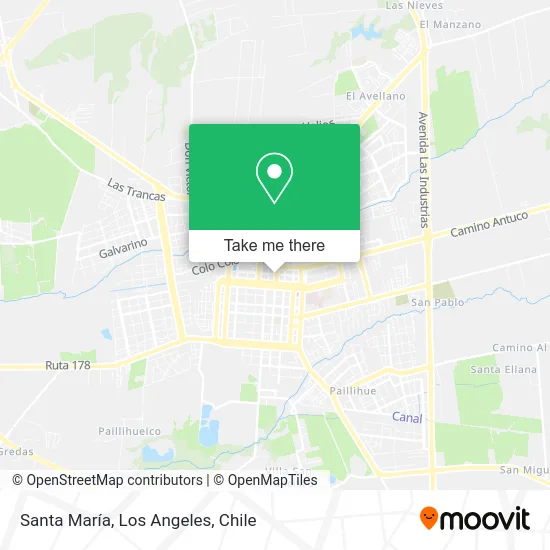
See Santa María, Los Ángeles, on the map
Public Transit to Santa María in Los Ángeles
Wondering how to get to Santa María in Los Ángeles? Moovit helps you find the best way to get to Santa María with step-by-step directions from the nearest public transit station.
Moovit provides free maps and live directions to help you navigate through your city. View schedules, routes, timetables, and find out how long does it take to get to Santa María in real time.
Looking for the nearest stop or station to Santa María? Check out this list of stops closest to your destination: Almagro / Caupolican; Ricardo Vicuna / Manuel Rodriguez; Ricardo Vicuna / Colon; Valdivia / Ricardo Vicuna; Mendoza / Avenida Ricardo Vicuna Norte; Ricardo Vicuna / San Martin; Ricardo Vicuna / Mendoza.
Bus: 2-R, 7-I, 4-I, 5-I, C7-I, C9-I, C10-I, 5-R, 10-R, C15-I, C25-I, C26-I, 8-R, C8-I, C11-I, C12-I, C24-I, 1-I, 6-I, 10-I, 7-R, C8V-I, C9V-R, 1-R.
Want to see if there’s another route that gets you there at an earlier time? Moovit helps you find alternative routes or times. Get directions from and directions to Santa María easily from the Moovit App or Website.
We make riding to Santa María easy, which is why over 1.5 million users, including users in Los Ángeles, trust Moovit as the best app for public transit. You don’t need to download an individual bus app or train app, Moovit is your all-in-one transit app that helps you find the best bus time or train time available.
For information on prices of bus, costs and ride fares to Santa María, please check the Moovit app.
Use the app to navigate to popular places including to the airport, hospital, stadium, grocery store, mall, coffee shop, school, college, and university.
Santa María Address: Santa María, Calle Caupolicán 504, 4440000 Los Ángeles, Bíobío street in Los Ángeles
- Outlet Los Angeles,
- Primer Juzgado De Policia Local,
- Los Lagos,
- 1 Y 2 Juzgado De Letras De Los Ángeles,
- Juzgados Civiles,
- SII - Servicio De Impuestos Internos Los Angeles,
- Iglesia Adventista del séptimo día, central Los Ángeles,
- Hotelera Muso,
- 1 Y 2 Juzgado Policía Local Los Ángeles,
- Registro Civil,
- Iglesia Adventista del Séptimo Día,
- Dirección General de Aguas,
- Parroquia San Miguel,
- Plaza de Armas,
- 11 de Septiembre,
- Prefectura de carabineros,
- Boutique Kitty,
- Mueblerias-Sociedad Comercial Oyarzun Limitada,
- Municipalidad de los Ángeles,
- Artequín
Places Near Santa María (Los Ángeles)
- Villa Parque Historiadores, Los Ángeles,
- Jardines de Rucalhue, Los Ángeles,
- Clínica Los Andes, Los Ángeles,
- Villa Mininco, Los Ángeles,
- 2° Juzgado de Policia Local, Los Angeles., Los Ángeles,
- Parque Lauquen Pje 7 Oriente Los Angeles Chile, Los Ángeles,
- Antuco, Los Ángeles,
- Cruce Los Ángeles - Santa Bárbara / Ralco, Los Ángeles,
- Avenida Las industrias - Los Ángeles, Los Ángeles,
- Villa Lomas De Santa María, Los Ángeles,
- Villa Las Tranqueras, Los Ángeles,
- Villa los Alcaldes, Los Ángeles,
- Ruta Q-61-R (Los Ángeles - Santa Bárbara / Ralco), Los Ángeles,
- camino cerro colorado, Los Ángeles,
- Villa España, Los Ángeles,
- Villa Jardines De La Republica (Av. Gabriela Mistral), Los Ángeles,
- Terminal Rural Vega Techada, Los Ángeles,
- Terminal Rodoviario Sta. María de Los Ángeles, Los Ángeles,
- Los Ángeles Chile, Los Ángeles,
- Villa Parque Lauquen, Los Ángeles
How to get to popular places in Los Angeles, Chile with public transit
Get around Los Ángeles by public transit!
Traveling around Los Ángeles has never been so easy. See step by step directions as you travel to any attraction, street or major public transit station. View bus and train schedules, arrival times, service alerts and detailed routes on a map, so you know exactly how to get to anywhere in Los Ángeles.
When traveling to any destination around Los Ángeles use Moovit's Live Directions with Get Off Notifications to know exactly where and how far to walk, how long to wait for your line, and how many stops are left. Moovit will alert you when it's time to get off — no need to constantly re-check whether yours is the next stop.
Wondering how to use public transit in Los Ángeles or how to pay for public transit in Los Ángeles? Moovit public transit app can help you navigate your way with public transit easily, and at minimum cost. It includes public transit fees, ticket prices, and costs. Looking for a map of Los Ángeles public transit lines? Moovit public transit app shows all public transit maps in Los Ángeles with all bus routes and stops on an interactive map.
Los Angeles, Chile has 1 transit type(s), including: bus, operated by several transit agencies, including Paillihue, Chiprodal Bolson, Iansa Avellano, Orompello Montecea, Transportes de pasajeros S.A., El esfuerzo, Paillihue Bolson, Ciudades de Chile, Las Americas, Linea Azul, Paillihue Avellano, Expreso Araucano, Sotracoli, San Sebastian and Duqueco