Directions to Simon Fairfield Public Library (East Douglas) with public transportation
The following transit lines have routes that pass near Simon Fairfield Public Library
How to get to Simon Fairfield Public Library by bus?
Click on the bus route to see step by step directions with maps, line arrival times and updated time schedules.
Which bus line stops near Simon Fairfield Public Library?
A
See Simon Fairfield Public Library, East Douglas, on the map
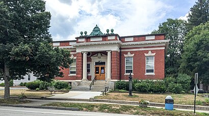
Public Transit to Simon Fairfield Public Library in East Douglas
Wondering how to get to Simon Fairfield Public Library in East Douglas, United States? Moovit helps you find the best way to get to Simon Fairfield Public Library with step-by-step directions from the nearest public transit station.
Moovit provides free maps and live directions to help you navigate through your city. View schedules, routes, timetables, and find out how long does it take to get to Simon Fairfield Public Library in real time.
Bus: A.
Want to see if there’s another route that gets you there at an earlier time? Moovit helps you find alternative routes or times. Get directions from and directions to Simon Fairfield Public Library easily from the Moovit App or Website.
We make riding to Simon Fairfield Public Library easy, which is why over 1.5 million users, including users in East Douglas, trust Moovit as the best app for public transit. You don’t need to download an individual bus app or train app, Moovit is your all-in-one transit app that helps you find the best bus time or train time available.
For information on prices of bus and train, costs and ride fares to Simon Fairfield Public Library, please check the Moovit app.
Use the app to navigate to popular places including to the airport, hospital, stadium, grocery store, mall, coffee shop, school, college, and university.
Simon Fairfield Public Library Address: 290 Main St street in East Douglas
Attractions near Simon Fairfield Public Library
Douglas House Of Pizza,Douglas Public Library,Webster Credit Union (Inc),Petraglia Real Estate Svc,Atlantic View Inc,1,East Douglas Village,Diggers Liquor Store,Curves For Women,Second Congregational Church,Classic Cuts Barber Shop,Black Lab Lounge,Ando's Restaurant & Catering,Archie's,Cjs Pet Supplies,Goodness Store,Fisherman's Friend Bait & Tckl,Harry's Famous Pizza,Douglas Post Office (historical),Blackstone Valley ChirorpraticHow to get to popular attractions in East Douglas with public transit
Chevalier Theater, Medford,Tremont Street, Boston,The Westin Copley Place, Boston, Boston,Sheraton, Boston,One Congress Street, Boston,Wonderland Parking Garage (Wonderland Station), Revere,Prudential Tower, Boston,Newbury Street, Boston,60 Fenwood Road, Boston,USS Constitution, Boston,800 Morrissey Blvd, Boston,Bedford, MA,MVRTA Lawrence Bus Station, Lawrence,Brigham and Women's Hospital, Boston,Samuel Adams Brewery, Boston,Franklin Park, Boston,Revere Beach, Revere,COURTYARD-Boston Cambridge (Cambridge Marriott), Cambridge,Brockton, Brockton,Columbus Ave, BostonGet around Boston by public transit!
Traveling around Boston has never been so easy. See step by step directions as you travel to any attraction, street or major public transit station. View bus and train schedules, arrival times, service alerts and detailed routes on a map, so you know exactly how to get to anywhere in Boston.
When traveling to any destination around Boston use Moovit's Live Directions with Get Off Notifications to know exactly where and how far to walk, how long to wait for your line, and how many stops are left. Moovit will alert you when it's time to get off — no need to constantly re-check whether yours is the next stop.
Wondering how to use public transit in Boston or how to pay for public transit in Boston? Moovit public transit app can help you navigate your way with public transit easily, and at minimum cost. It includes public transit fees, ticket prices, and costs. Looking for a map of Boston public transit lines? Moovit public transit app shows all public transit maps in Boston with all Bus, Train, Subway and Ferry routes and stops on an interactive map.
Boston has 4 transit type(s), including: Bus, Train, Subway and Ferry, operated by several transit agencies, including MBTA, Southeastern Regional Transit Authority, MetroWest Regional Transit Authority, Rhode Island Public Transit Authority, WRTA, Lowell Regional Transit Authority, Merrimack Valley Transit, Montachusett Regional Transit Authority, Cape Cod Regional Transit Authority, Brockton Area Transit Authority, Martha's Vineyard Transit Authority, the WAVE - Nantucket Regional Transit Authority, GATRA, Cape Ann Transportation Authority, Massport