Skørping Station stop - Wednesday schedule
| Line | Direction | Time |
|---|---|---|
| 104 | Terndrup Busterminal | 07:11 |
| 53 | Støvring | 08:04 |
| 53 | Karensmindeskolen | 08:04 |
| 104 | Terndrup Busterminal | 08:41 |
| 53 | Støvring | 09:59 |
| 104 | Terndrup Busterminal | 10:41 |
| 104 | Terndrup Busterminal | 12:41 |
| 104 | Terndrup Busterminal | 13:24 |
| 380 | Skørping Skole (Hallen Ved Skørping Idrætscenter) | 13:44 |
| 104 | Terndrup Busterminal | 14:16 |
| 380 | Skørping Skole (Hallen Ved Skørping Idrætscenter) | 14:34 |
| 104 | Terndrup Busterminal | 14:43 |
| 380 | Skørping Skole (Hallen Ved Skørping Idrætscenter) | 15:24 |
| 104 | Terndrup Busterminal | 15:35 |
| 53 | Støvring | 15:38 |
| 104 | Terndrup Busterminal | 16:28 |
Directions to Skørping Station (Rebild) with public transportation
The following transit lines have routes that pass near Skørping Station
How to get to Skørping Station by bus?
Click on the bus route to see step by step directions with maps, line arrival times and updated time schedules.
Bus stations near Skørping Station in Rebild
- Skørping St. (Togbus), 1 min walk,
- Skørping Station, 1 min walk,
Bus lines to Skørping Station in Rebild
- GRØN, Aalborg St. (Togbus),
- RØD, Hobro St. (Togbus),
- GUL, Skørping Station - Aalborg St. (Område C / Regionalbus),
- 53, Arden Station (Mariagerfjord Kommune) - Støvring St.,
- 53N, Budolfi Plads (Vingårdsgade / Aalborg) - Arden Station (Mariagerfjord Kommune),
- 104, Karensmindeskolen (Mastrupvej / Støvring) - Terndrup Busterminal,
- 380, Sejlstrup (Skørping) - Skørping Skole (Hallen ved Skørping Idrætscenter),
What are the closest stations to Skørping Station?
The closest stations to Skørping Station are:
- Skørping St. (Togbus) is 31 meters away, 1 min walk.
- Skørping Station is 31 meters away, 1 min walk.
Which bus line stops near Skørping Station?
RØD
What’s the nearest bus stop to Skørping Station in Rebild?
The nearest bus stops to Skørping Station in Rebild are Skørping St. (Togbus) and Skørping Station. The closest one is a 1 min walk away.
What time is the first bus to Skørping Station in Rebild?
The GRØN is the first bus that goes to Skørping Station in Rebild. It stops nearby at 3:39 AM.
What time is the last bus to Skørping Station in Rebild?
The RØD is the last bus that goes to Skørping Station in Rebild. It stops nearby at 1:12 AM.
See Skørping Station, Rebild, on the map
Public transit to Skørping Station stop in Rebild
Looking for directions to Skørping Station in Rebild, Denmark?
Download the Moovit App to find the current schedule and step-by-step directions for Bus routes that pass through Skørping Station.
Looking for the nearest stops closest to Skørping Station ? Check out this list of closest stops to your destination: Skørping St. (Togbus); Skørping Station.
Bus: RØD, GRØN, GUL, 53, 53N, 104, 380.
We make riding on public transit to Skørping Station easy, which is why over 1.5 million users, including users in Rebild trust Moovit as the best app for public transit.
Use the app to navigate to popular places including to the airport, hospital, stadium, grocery store, mall, coffee shop, school, college, and university.
The first line to this stop is 104, at 07:11, and the last line is 104 at 16:28.
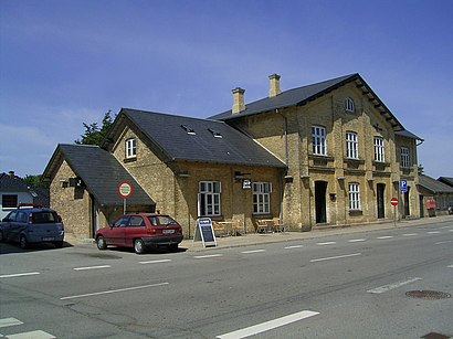
Sverriggårdsvej 3, Skørping, Denmark
This stop serves NT’s lines
Popular public transit stations in Rebild
Frichsparken/Søren Frichs Vej (Aarhus Kom),Måløv St.,Strandby Kirkevej V Skoleparken (Esbjerg),Nordsøvej (Kattegatvej),Vindeby (Langeland Kommune),Den Blå Planet (Amager Strandvej),Bjørnstrup (Røsnæsvej),Nørrebro St. (Folmer Bendtsens Plads),Skalborg St.,Kærvanghus (Sønderbro / Aalborg),Tuborg Boulevard (Strandvejen),København H,Lokalcenter Skåde/Bushøjvænget (Aarhus Kom),Bispebjerg Hospital (Tagensvej),Falkoner Allé (Godthåbsvej),Sintrupvej/Holmstrupgårdvej (Aarhus Kom),Kirkesvinget,Strandvejen (Hellerupvej),Christiansfeld Omfartsvejen,Haraldsgade (Lyngbyvej)Get around Denmark by public transit!
Traveling around Denmark has never been so easy. See step by step directions as you travel to any attraction, street or major public transit station. View bus and train schedules, arrival times, service alerts and detailed routes on a map, so you know exactly how to get to anywhere in Denmark.
When traveling to any destination around Denmark use Moovit's Live Directions with Get Off Notifications to know exactly where and how far to walk, how long to wait for your line, and how many stops are left. Moovit will alert you when it's time to get off — no need to constantly re-check whether yours is the next stop.
Wondering how to use public transit in Denmark or how to pay for public transit in Denmark? Moovit public transit app can help you navigate your way with public transit easily, and at minimum cost. It includes public transit fees, ticket prices, and costs. Looking for a map of Denmark public transit lines? Moovit public transit app shows all public transit maps in Denmark with all Bus, Train, Metro, Light Rail and Ferry routes and stops on an interactive map.
Denmark has 5 transit type(s), including: Bus, Train, Metro, Light Rail and Ferry, operated by several transit agencies, including Metroselskabet, DSB S-tog, Lokaltog A/S, Midttrafik, Odense Letbane, DSB, NT, GoCollective, Skånetrafiken, Movia, FYNBUS, Sydtrafik, Bornholms Trafik, Citybus, Ærø Kommune