Directions to Skagen Havn with public transportation
The following transit lines have routes that pass near Skagen Havn
How to get to Skagen Havn by train?
Click on the train route to see step by step directions with maps, line arrival times and updated time schedules.
Which train line stops near Skagen Havn?
75
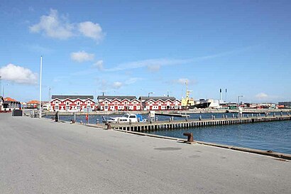
See Skagen Havn on the map
Public Transportation to Skagen Havn
Wondering how to get to Skagen Havn, Denmark? Moovit helps you find the best way to get to Skagen Havn with step-by-step directions from the nearest public transit station.
Moovit provides free maps and live directions to help you navigate through your city. View schedules, routes, timetables, and find out how long does it take to get to Skagen Havn in real time.
Train:75
Want to see if there’s another route that gets you there at an earlier time? Moovit helps you find alternative routes or times. Get directions from and directions to Skagen Havn easily from the Moovit App or Website.
We make riding to Skagen Havn easy, which is why over 1.5 million users, including users in Skagen, trust Moovit as the best app for public transit. You don’t need to download an individual bus app or train app, Moovit is your all-in-one transit app that helps you find the best bus time or train time available.
For information on prices of train and bus, costs and ride fares to Skagen Havn, please check the Moovit app.
Use the app to navigate to popular places including to the airport, hospital, stadium, grocery store, mall, coffee shop, school, college, and university.
Skagen Havn Address: Havnevagtvej 30 street in Skagen
Attractions near Skagen Havn
Aavang Fiskehandel, Erik,Aavangs Fiskehus,Havnens Fiskehandel Skagen,Karma Sushi - Skagen,Mamafelia,Antik & Gammelt,Glyngøre Huset,Christiansens Eftf., Harald,Skagen Daghøjskole,Skibsproviantering Harald Christiansens Eftf.,Wittco Fisk & Skaldyr,Torvehallerne,Havnegrillen,Havnens Fiskehus,Skagen Fiskerestaurant,Ultramarine A/S,Holte Vinlager,Nibe-Hansen,Skagen Turistbureau,Havfruen FiskehusHow to get to popular attractions in Skagen with public transit
LEGO System A/S, Billund,Novo Nordisk/ Hagedornsvej, Gentofte,Bellahøj, København,Memphis Mansion, Randers,Virum, Lyngby-Taarbæk,Tryg Forsikring Kantinen, Ballerup,Greve Station, Greve,Hirtshals Havn, Hjørring,Syddansk Universitet, Odense,Åmarken Station, Hvidovre,Skolerne i Oure - Sport & Performance, Svendborg,Skagen, Frederikshavn,Studenterhus Aarhus, Århus,Givskud Zoo - Løveparken, Vejle,LEGO Project House, Billund,Munkebjerg Hotel & Casino, Vejle,Vigerslev Alle Station, København,Hotel Propellen Billund, Billund,Lønstrup, Hjørring,Meny, AalborgGet around Skagen by public transit!
Traveling around Skagen has never been so easy. See step by step directions as you travel to any attraction, street or major public transit station. View bus and train schedules, arrival times, service alerts and detailed routes on a map, so you know exactly how to get to anywhere in Skagen.
When traveling to any destination around Skagen use Moovit's Live Directions with Get Off Notifications to know exactly where and how far to walk, how long to wait for your line, and how many stops are left. Moovit will alert you when it's time to get off — no need to constantly re-check whether yours is the next stop.
Wondering how to use public transit in Skagen or how to pay for public transit in Skagen? Moovit public transit app can help you navigate your way with public transit easily, and at minimum cost. It includes public transit fees, ticket prices, and costs. Looking for a map of Skagen public transit lines? Moovit public transit app shows all public transit maps in Skagen with all train or bus routes and stops on an interactive map.
Skagen has 2 transit type(s), including: train or bus, operated by several transit agencies, including Metroselskabet, DSB S-tog, Lokaltog A/S, DSB S-tog, Midttrafik, Odense Letbane, DSB, NT, GoCollective, Midttrafik, Skånetrafiken, Metroselskabet, Movia, NT and Midttrafik