How to get to South Shore Neptunes Dive Club by bus?
Click on the bus route to see step by step directions with maps, line arrival times and updated time schedules.
From new hampshire!, Boston
67 minFrom Andrew Station - MBTA - Red Line, Boston
51 minFrom Childrens Museum, Boston
66 minFrom O'Bryant High School, Boston
59 minFrom Residence Inn by Marriott Boston Downtown/South End, Boston
62 minFrom Capo Restaurant & Supper Club, Boston
67 minFrom South Boston, Boston
62 minFrom Codman Square, Boston
36 minFrom Roxbury, Boston
59 minFrom Centre St, Boston
49 min
How to get to South Shore Neptunes Dive Club by train?
Click on the train route to see step by step directions with maps, line arrival times and updated time schedules.
From new hampshire!, Boston
86 minFrom Andrew Station - MBTA - Red Line, Boston
107 minFrom Childrens Museum, Boston
97 minFrom O'Bryant High School, Boston
85 minFrom Residence Inn by Marriott Boston Downtown/South End, Boston
81 minFrom South Boston, Boston
98 minFrom Codman Square, Boston
104 minFrom Roxbury, Boston
80 min
How to get to South Shore Neptunes Dive Club by subway?
Click on the subway route to see step by step directions with maps, line arrival times and updated time schedules.
From new hampshire!, Boston
69 minFrom Andrew Station - MBTA - Red Line, Boston
47 minFrom Childrens Museum, Boston
68 minFrom O'Bryant High School, Boston
74 minFrom Residence Inn by Marriott Boston Downtown/South End, Boston
75 minFrom Capo Restaurant & Supper Club, Boston
63 minFrom South Boston, Boston
58 minFrom Codman Square, Boston
65 minFrom Roxbury, Boston
74 minFrom Centre St, Boston
71 min
Bus stops near South Shore Neptunes Dive Club in Quincy
Subway stations near South Shore Neptunes Dive Club in Quincy
Bus lines to South Shore Neptunes Dive Club in Quincy
What are the closest stations to South Shore Neptunes Dive Club?
The closest stations to South Shore Neptunes Dive Club are:
- Adams St @ White St is 202 yards away, 3 min walk.
- Robertson St @ Quarry St is 410 yards away, 5 min walk.
- Cedar Grove is 1484 yards away, 18 min walk.
- North Quincy is 2131 yards away, 25 min walk.
Which bus line stops near South Shore Neptunes Dive Club?
215 (Quincy Center)
Which train line stops near South Shore Neptunes Dive Club?
GREENBUSH (#1061 | Greenbush)
Which subway line stops near South Shore Neptunes Dive Club?
RED LINE (Ashmont/Braintree)
What’s the nearest subway station to South Shore Neptunes Dive Club in Quincy?
The nearest subway station to South Shore Neptunes Dive Club in Quincy is Cedar Grove. It’s a 18 min walk away.
What’s the nearest bus station to South Shore Neptunes Dive Club in Quincy?
The nearest bus station to South Shore Neptunes Dive Club in Quincy is Adams St @ White St. It’s a 3 min walk away.
What time is the first subway to South Shore Neptunes Dive Club in Quincy?
The MATTAPAN LINE is the first subway that goes to South Shore Neptunes Dive Club in Quincy. It stops nearby at 5:06 AM.
What time is the last subway to South Shore Neptunes Dive Club in Quincy?
The MATTAPAN LINE is the last subway that goes to South Shore Neptunes Dive Club in Quincy. It stops nearby at 2:35 AM.
What time is the first bus to South Shore Neptunes Dive Club in Quincy?
The 215 is the first bus that goes to South Shore Neptunes Dive Club in Quincy. It stops nearby at 5:14 AM.
What time is the last bus to South Shore Neptunes Dive Club in Quincy?
The 215 is the last bus that goes to South Shore Neptunes Dive Club in Quincy. It stops nearby at 1:10 AM.
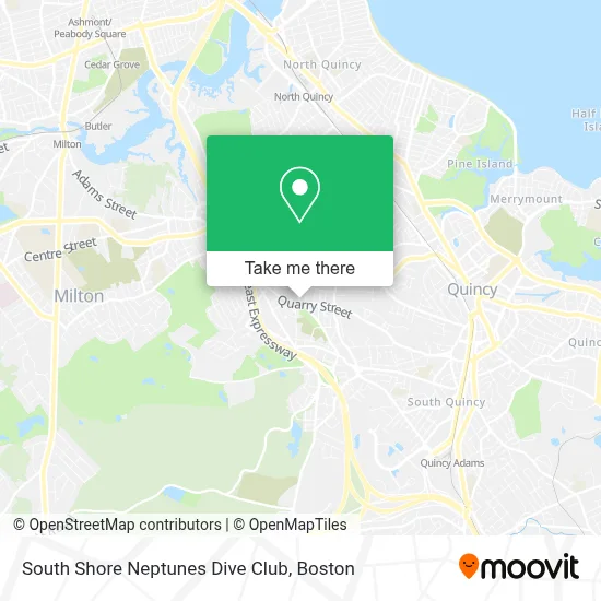
See South Shore Neptunes Dive Club, Quincy, on the map
Public Transit to South Shore Neptunes Dive Club in Quincy
Wondering how to get to South Shore Neptunes Dive Club in Quincy? Moovit helps you find the best way to get to South Shore Neptunes Dive Club with step-by-step directions from the nearest public transit station.
Moovit provides free maps and live directions to help you navigate through your city. View schedules, routes, timetables, and find out how long does it take to get to South Shore Neptunes Dive Club in real time.
Looking for the nearest stop or station to South Shore Neptunes Dive Club? Check out this list of stops closest to your destination: Adams St @ White St; Robertson St @ Quarry St; Cedar Grove; North Quincy.
Bus: 215, 245, 217.Train: GREENBUSH.Subway: RED LINE, MATTAPAN LINE.
Want to see if there’s another route that gets you there at an earlier time? Moovit helps you find alternative routes or times. Get directions from and directions to South Shore Neptunes Dive Club easily from the Moovit App or Website.
We make riding to South Shore Neptunes Dive Club easy, which is why over 1.7 million users, including users in Quincy, trust Moovit as the best app for public transit. You don’t need to download an individual bus app or train app, Moovit is your all-in-one transit app that helps you find the best bus time or train time available.
For information on prices of bus, subway and train, costs and ride fares to South Shore Neptunes Dive Club, please check the Moovit app.
Use the app to navigate to popular places including to the airport, hospital, stadium, grocery store, mall, coffee shop, school, college, and university.
South Shore Neptunes Dive Club Address: Corner of, Quarry St & Joyce Rd street in Quincy
- Larry Moreton Fence Co.,
- Crime Scene Cleanup Massachusetts,
- In Sync Dance,
- Atm Walgreens,
- TD Bank Atm,
- Evelina Fitzgerald - TD Wealth Financial Advisor,
- East Milton Square,
- The Home Depot,
- Home Depot Quincy,
- TD Bank,
- NPH USA-Mid-Atlantic,
- Montilios Quincy,
- Express Locksmith Inc,
- Quincy Smoke Shop,
- Enterprise Rent-A-Car,
- Care Dental,
- Care Dental Implants & Invisalign Center,
- Darcy's Pub,
- The Color Bar,
- Quincy Locksmith Shop
Places Near South Shore Neptunes Dive Club (Quincy)
- Leader Bank Pavilion (Leader Bank Pavillion), Boston,
- Wang Theater, Boston,
- Boston Medical Center, Boston,
- House Of Blues, Boston,
- Boston Convention & Exhibition Center, Boston,
- Boston Common, Boston,
- Quincy Market, Boston,
- Prudential Center, Boston,
- Isabella Stewart Gardner Museum, Boston,
- Cheers, Boston,
- Faneuil Hall, Boston,
- Td Garden, Boston,
- North End, Boston,
- Mgm Music Hall, Boston,
- Seaport District, Boston,
- Museum Of Science, Boston,
- Wilbur Theatre, Boston,
- Massachusetts General Hospital, Boston,
- Boston Children's Hospital, Boston,
- Castle Island, Boston
How to get to popular places in Boston with public transit
Get around Quincy by public transit!
Traveling around Quincy has never been so easy. See step by step directions as you travel to any attraction, street or major public transit station. View bus and train schedules, arrival times, service alerts and detailed routes on a map, so you know exactly how to get to anywhere in Quincy.
When traveling to any destination around Quincy use Moovit's Live Directions with Get Off Notifications to know exactly where and how far to walk, how long to wait for your line, and how many stops are left. Moovit will alert you when it's time to get off — no need to constantly re-check whether yours is the next stop.
Wondering how to use public transit in Quincy or how to pay for public transit in Quincy? Moovit public transit app can help you navigate your way with public transit easily, and at minimum cost. It includes public transit fees, ticket prices, and costs. Looking for a map of Quincy public transit lines? Moovit public transit app shows all public transit maps in Quincy with all Bus, Train, Subway and Ferry routes and stops on an interactive map.
Boston has 4 transit type(s), including: Bus, Train, Subway and Ferry, operated by several transit agencies, including MBTA, Southeastern Regional Transit Authority, MetroWest Regional Transit Authority, Rhode Island Public Transit Authority, WRTA, Lowell Regional Transit Authority, Merrimack Valley Transit, Montachusett Regional Transit Authority, Cape Cod Regional Transit Authority, Brockton Area Transit Authority, Martha's Vineyard Transit Authority, the WAVE - Nantucket Regional Transit Authority, GATRA, Cape Ann Transportation Authority and Massport