Directions to Southeast 17th Avenue (Portland, OR) with public transportation
The following transit lines have routes that pass near Southeast 17th Avenue
How to get to Southeast 17th Avenue by bus?
Click on the bus route to see step by step directions with maps, line arrival times and updated time schedules.
Bus stations near Southeast 17th Avenue in Portland, OR
- Se Milwaukie & Long (South),3 min walk,
Bus lines to Southeast 17th Avenue in Portland, OR
- 19,Flavel & I-205 Overpass (East),
- 70,NE Sunderland & Columbia River Corr Inst (South),
What are the closest stations to Southeast 17th Avenue?
The closest stations to Southeast 17th Avenue are:
- Se Milwaukie & Long (South) is 214 yards away, 3 min walk.
Which bus lines stop near Southeast 17th Avenue?
These bus lines stop near Southeast 17th Avenue: 19, 70.
Which light rail line stops near Southeast 17th Avenue?
MAX ORANGE LINE
What’s the nearest bus stop to Southeast 17th Avenue in Portland, OR?
The nearest bus stop to Southeast 17th Avenue in Portland, OR is Se Milwaukie & Long (South). It’s a 3 min walk away.
See Southeast 17th Avenue, Portland, OR, on the map
Public Transit to Southeast 17th Avenue in Portland, OR
Wondering how to get to Southeast 17th Avenue in Portland, OR, United States? Moovit helps you find the best way to get to Southeast 17th Avenue with step-by-step directions from the nearest public transit station.
Moovit provides free maps and live directions to help you navigate through your city. View schedules, routes, timetables, and find out how long does it take to get to Southeast 17th Avenue in real time.
Looking for the nearest stop or station to Southeast 17th Avenue? Check out this list of stops closest to your destination: Se Milwaukie & Long (South).
Bus:1970Light Rail:MAX ORANGE LINE
Want to see if there’s another route that gets you there at an earlier time? Moovit helps you find alternative routes or times. Get directions from and directions to Southeast 17th Avenue easily from the Moovit App or Website.
We make riding to Southeast 17th Avenue easy, which is why over 1.5 million users, including users in Portland, OR, trust Moovit as the best app for public transit. You don’t need to download an individual bus app or train app, Moovit is your all-in-one transit app that helps you find the best bus time or train time available.
For information on prices of bus and light rail, costs and ride fares to Southeast 17th Avenue, please check the Moovit app.
Use the app to navigate to popular places including to the airport, hospital, stadium, grocery store, mall, coffee shop, school, college, and university.
Location: Portland, OR
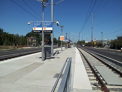
Southeast 17th Avenue and Holgate Boulevard is a MAX Orange Line station located in the median of Southeast 17th Avenue at Holgate Boulevard in the Brooklyn neighborhood of Portland, Oregon.Wiki
Attractions near Southeast 17th Avenue
EcoFloors,Peco, Inc.,SE Milwaukie & Long,Coco Donuts - Portland,Brooklyn Yard,Cambridge Square Apartments,4780 SE Milwaukie Ave,Coco Donuts,The Iron Tap Station,Chicagoland,Stor-room mini storage,Cascade Direct in Portland, OR, USA,Budget Rental Truck,D&H Flagging,Bar 33 Brooklyn,4729 Southeast Milwaukie Avenue,Yummy Garden in Portland, OR, USA,The Lynch Company,Trackers,Portland Marble WorksHow to get to popular attractions in Portland, OR with public transit
Intel - JF4, Hillsboro,Residence Inn Portland Airport at Cascade Station, Portland,Nike - Dan Fouts Building,Lewis And Clark College, Portland,TriMet Washington / SE 12th Ave MAX Station, Hillsboro,Ringlers Pub, Portland,Portland Union Station, Portland,Kaiser Permanente Building, Portland,TriMet E 181st Ave MAX Station, Gresham,Columbia Sportswear Company, Portland,City of Battle Ground, Battle Ground,Portland Marriott Downtown Waterfront, Portland,Clark College, Vancouver,Saburo's Sushi House, Portland,Kells Irish Restaurant & Pub, Portland,TriMet E 162nd Ave MAX Station, Gresham,Tanasbourne, Hillsboro,Portland Japanese Garden, Portland,TriMet SE Powell Blvd MAX Station, Portland,Kohl's Portland Gateway, PortlandGet around Portland, OR by public transit!
Traveling around Portland, OR has never been so easy. See step by step directions as you travel to any attraction, street or major public transit station. View bus and train schedules, arrival times, service alerts and detailed routes on a map, so you know exactly how to get to anywhere in Portland, OR.
When traveling to any destination around Portland, OR use Moovit's Live Directions with Get Off Notifications to know exactly where and how far to walk, how long to wait for your line, and how many stops are left. Moovit will alert you when it's time to get off — no need to constantly re-check whether yours is the next stop.
Wondering how to use public transit in Portland, OR or how to pay for public transit in Portland, OR? Moovit public transit app can help you navigate your way with public transit easily, and at minimum cost. It includes public transit fees, ticket prices, and costs. Looking for a map of Portland, OR public transit lines? Moovit public transit app shows all public transit maps in Portland, OR with all bus or light rail routes and stops on an interactive map.
Portland, OR has 2 transit type(s), including: bus or light rail, operated by several transit agencies, including Mount Adams Transportation Service, RiverCities Transit, TriMet , TriMet , TriMet, Portland Streetcar, Portland Aerial Tram, C-TRAN, Multnomah County Job Connector Shuttles, Washington Park Shuttle, SMART, Canby Area Transit, South Clackamas Transportation District, The Wave and Lincoln County Transit