See Station Klarenbeek, Voorst, on the map
Directions to Station Klarenbeek (Voorst) with public transportation
The following transit lines have routes that pass near Station Klarenbeek
 Bus:
Bus: - Train:
How to get to Station Klarenbeek by bus?
Click on the bus route to see step by step directions with maps, line arrival times and updated time schedules.
How to get to Station Klarenbeek by train?
Click on the train route to see step by step directions with maps, line arrival times and updated time schedules.
Bus stations near Station Klarenbeek in Voorst
- Klarenbeek, Station,1 min walk,
Train stations near Station Klarenbeek in Voorst
- Klarenbeek,28 min walk,
Bus lines to Station Klarenbeek in Voorst
- 506,Twello,
- 508,Klarenbeek,
What are the closest stations to Station Klarenbeek?
The closest stations to Station Klarenbeek are:
- Klarenbeek, Station is 45 meters away, 1 min walk.
- Klarenbeek is 2147 meters away, 28 min walk.
Which bus lines stop near Station Klarenbeek?
These bus lines stop near Station Klarenbeek: 506, 508.
Which train line stops near Station Klarenbeek?
RS
What’s the nearest train station to Station Klarenbeek in Voorst?
The nearest train station to Station Klarenbeek in Voorst is Klarenbeek. It’s a 28 min walk away.
What’s the nearest bus stop to Station Klarenbeek in Voorst?
The nearest bus stop to Station Klarenbeek in Voorst is Klarenbeek, Station. It’s a 1 min walk away.
What time is the first train to Station Klarenbeek in Voorst?
The RS is the first train that goes to Station Klarenbeek in Voorst. It stops nearby at 6:21 AM.
What time is the last train to Station Klarenbeek in Voorst?
The RS is the last train that goes to Station Klarenbeek in Voorst. It stops nearby at 12:09 AM.
What time is the first bus to Station Klarenbeek in Voorst?
The 508 is the first bus that goes to Station Klarenbeek in Voorst. It stops nearby at 6:48 AM.
What time is the last bus to Station Klarenbeek in Voorst?
The 508 is the last bus that goes to Station Klarenbeek in Voorst. It stops nearby at 5:48 PM.
See Station Klarenbeek, Voorst, on the map
Public Transit to Station Klarenbeek in Voorst
Wondering how to get to Station Klarenbeek in Voorst, Netherlands? Moovit helps you find the best way to get to Station Klarenbeek with step-by-step directions from the nearest public transit station.
Moovit provides free maps and live directions to help you navigate through your city. View schedules, routes, timetables, and find out how long does it take to get to Station Klarenbeek in real time.
Looking for the nearest stop or station to Station Klarenbeek? Check out this list of stops closest to your destination: Klarenbeek; Klarenbeek.
Bus:Train:
Want to see if there’s another route that gets you there at an earlier time? Moovit helps you find alternative routes or times. Get directions from and directions to Station Klarenbeek easily from the Moovit App or Website.
We make riding to Station Klarenbeek easy, which is why over 1.5 million users, including users in Voorst, trust Moovit as the best app for public transit. You don’t need to download an individual bus app or train app, Moovit is your all-in-one transit app that helps you find the best bus time or train time available.
For information on prices of train and bus, costs and ride fares to Station Klarenbeek, please check the Moovit app.
Use the app to navigate to popular places including to the airport, hospital, stadium, grocery store, mall, coffee shop, school, college, and university.
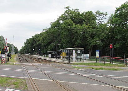
Station Klarenbeek Address: Hoofdweg street in Voorst
Attractions near Station Klarenbeek
Kabouterbos Klarenbeek,H.S.V. Ons Genoegen,Klarenbeek,Thermen Bussloo,Logistic Care,C1000,Plus Imanse / Pijnappel Mode,Vattenfall InCharge,L ten Teije - Amus,Sauna & Wellness resort Thermen Bussloo,Jeugdcentr Hulsb,Carnavalsverenigin,EVnetNL,Thermen Bussloo Welness & Hotel,Bussloo, Thermen Bussloo,Thermen Bussloo,Reuvekamp Minikraanverhuur,Spooktocht Je,Margreet's Borduurshop,Vattenfall InChargeHow to get to popular attractions in Voorst with public transit
Station Geldermalsen, Geldermalsen,Madurodam, 'S-Gravenhage,Winkelcentrum Kronenburg, Arnhem,Vrijthof, Maastricht,Station Bergen op Zoom, Bergen Op Zoom,Jeroen Bosch Ziekenhuis, 'S-Hertogenbosch,IKEA, Utrecht,ss Rotterdam, Rotterdam,Station Zwijndrecht, Zwijndrecht,SnowWorld, Landgraaf,Batavia Stad Fashion Outlet, Lelystad,Saxion Hogeschool (Ko Wierenga), Enschede,Apeldoorn, Apeldoorn,ANWB Hoofdkantoor, Wassenaar,IKEA, Groningen,Knooppunt Kleinpolderplein, Rotterdam,Busstation Hoofdstation, Groningen,Boulevard Scheveningen, 'S-Gravenhage,Droomvlucht, Loon Op Zand,Safaripark Beekse Bergen, HilvarenbeekGet around Voorst by public transit!
Traveling around Voorst has never been so easy. See step by step directions as you travel to any attraction, street or major public transit station. View bus and train schedules, arrival times, service alerts and detailed routes on a map, so you know exactly how to get to anywhere in Voorst.
When traveling to any destination around Voorst use Moovit's Live Directions with Get Off Notifications to know exactly where and how far to walk, how long to wait for your line, and how many stops are left. Moovit will alert you when it's time to get off — no need to constantly re-check whether yours is the next stop.
Wondering how to use public transit in Voorst or how to pay for public transit in Voorst? Moovit public transit app can help you navigate your way with public transit easily, and at minimum cost. It includes public transit fees, ticket prices, and costs. Looking for a map of Voorst public transit lines? Moovit public transit app shows all public transit maps in Voorst with all train or bus routes and stops on an interactive map.
Voorst has 2 transit type(s), including: train or bus, operated by several transit agencies, including NS, NS International, GVB, GVB, GVB, GVB, U-OV, U-OV, Overal, HTM, R-net, RET, RET, De Lijn and Connexxion