Directions to Stengården st. (Gladsaxe) with public transportation
The following transit lines have routes that pass near Stengården st.
How to get to Stengården st. by bus?
Click on the bus route to see step by step directions with maps, line arrival times and updated time schedules.
How to get to Stengården st. by train?
Click on the train route to see step by step directions with maps, line arrival times and updated time schedules.
Bus stations near Stengården st. in Gladsaxe
- Stengården St. (Gammelmosevej),3 min walk,
- Amundsensvej (Bagsværdvej),19 min walk,
- Nybrovej (Engelsborgvej),27 min walk,
Train stations near Stengården st. in Gladsaxe
- Nørgaardsvej St.,50 min walk,
- Jægersborg St.,50 min walk,
Bus lines to Stengården st. in Gladsaxe
- 68,Islands Brygge Via Utterslev Torv,
- 400,Hundige St.,
- 400S,Lyngby St.,
What are the closest stations to Stengården st.?
The closest stations to Stengården st. are:
- Stengården St. (Gammelmosevej) is 192 meters away, 3 min walk.
- Amundsensvej (Bagsværdvej) is 1486 meters away, 19 min walk.
- Nybrovej (Engelsborgvej) is 2030 meters away, 27 min walk.
- Nørgaardsvej St. is 3715 meters away, 50 min walk.
- Jægersborg St. is 3748 meters away, 50 min walk.
Which bus lines stop near Stengården st.?
These bus lines stop near Stengården st.: 166, 68.
Which train lines stop near Stengården st.?
These train lines stop near Stengården st.: B, BX.
What’s the nearest bus stop to Stengården st. in Gladsaxe?
The nearest bus stop to Stengården st. in Gladsaxe is Stengården St. (Gammelmosevej). It’s a 3 min walk away.
See Stengården st., Gladsaxe, on the map
Public Transit to Stengården st. in Gladsaxe
Wondering how to get to Stengården st. in Gladsaxe, Denmark? Moovit helps you find the best way to get to Stengården st. with step-by-step directions from the nearest public transit station.
Moovit provides free maps and live directions to help you navigate through your city. View schedules, routes, timetables, and find out how long does it take to get to Stengården st. in real time.
Looking for the nearest stop or station to Stengården st.? Check out this list of stops closest to your destination: Stengården St. (Gammelmosevej); Amundsensvej (Bagsværdvej); Nybrovej (Engelsborgvej); Nørgaardsvej St.; Jægersborg St..
Bus:16668400400STrain:BBX910AE
Want to see if there’s another route that gets you there at an earlier time? Moovit helps you find alternative routes or times. Get directions from and directions to Stengården st. easily from the Moovit App or Website.
We make riding to Stengården st. easy, which is why over 1.5 million users, including users in Gladsaxe, trust Moovit as the best app for public transit. You don’t need to download an individual bus app or train app, Moovit is your all-in-one transit app that helps you find the best bus time or train time available.
For information on prices of train and bus, costs and ride fares to Stengården st., please check the Moovit app.
Use the app to navigate to popular places including to the airport, hospital, stadium, grocery store, mall, coffee shop, school, college, and university.
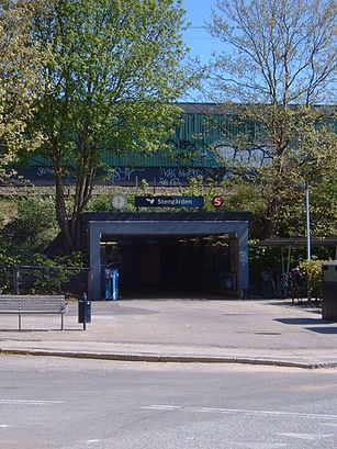
Stengården st. Address: Gammelmosevej street in Gladsaxe
Stengården station is a station on the Farum radial of the S-train network in Copenhagen, Denmark.Wiki
Attractions near Stengården st.
The Stengården Party Circle,1 & 2,Stengård Skole,Stengården Station,Triumf Pizzaria Grill,Pølle-Pladsen,P.O. Pedersen Kollegiet,Bagsværd Hovedgade 6,Fyrrummet,Ny Bagsværd Skole,Stengårds Alle 122-128,Mario's Pizza Bar,REMA 1000,Bagsværd Skole,Stengårds Allé,Irma,Drømmesengen,Ude,Bagsværd Hovedgade 62,AldershvilevejHow to get to popular attractions in Gladsaxe with public transit
Kolding Sygehus, Kolding,Køge handelsskole, Køge,AARHUS TECH, Århus,Finsensvej, Frederiksberg,Dansk Supermarked, Århus,Høje Taastrup Station, Busholdepladsen, Høje Taastrup,IKEA Restaurant & Cafe, Gentofte,Stjernepladsen, Århus,Fitness dk, Odense,Haslev Station, Faxe,LEGO Project House, Billund,Vigerslev Alle Station, København,Linie 888, Abildskou, København,Meny, Aalborg,Øgaderne, Århus,Vejle Transportcenter, Vejle,The Shop, Odense,Comwell Kolding, Kolding,Regionshospitalet Herning, Herning,Studenterhus Aarhus, ÅrhusGet around Gladsaxe by public transit!
Traveling around Gladsaxe has never been so easy. See step by step directions as you travel to any attraction, street or major public transit station. View bus and train schedules, arrival times, service alerts and detailed routes on a map, so you know exactly how to get to anywhere in Gladsaxe.
When traveling to any destination around Gladsaxe use Moovit's Live Directions with Get Off Notifications to know exactly where and how far to walk, how long to wait for your line, and how many stops are left. Moovit will alert you when it's time to get off — no need to constantly re-check whether yours is the next stop.
Wondering how to use public transit in Gladsaxe or how to pay for public transit in Gladsaxe? Moovit public transit app can help you navigate your way with public transit easily, and at minimum cost. It includes public transit fees, ticket prices, and costs. Looking for a map of Gladsaxe public transit lines? Moovit public transit app shows all public transit maps in Gladsaxe with all train or bus routes and stops on an interactive map.
Gladsaxe has 2 transit type(s), including: train or bus, operated by several transit agencies, including Metroselskabet, DSB S-tog, Lokaltog A/S, DSB S-tog, Midttrafik, Odense Letbane, DSB, NT, GoCollective, Midttrafik, Skånetrafiken, Metroselskabet, Movia, NT and Midttrafik