Directions to Sukran Ergin, Md (Boston) with public transportation
The following transit lines have routes that pass near Sukran Ergin, Md
 Bus: 501, 57, 65, 86, 66.
- Train: FRAMINGHAM/WORCESTER.
- Subway: GREEN LINE B.
How to get to Sukran Ergin, Md by bus?
Click on the bus route to see step by step directions with maps, line arrival times and updated time schedules.
From UMass Boston Campus Center, Boston
83 minFrom One Federal, Boston
37 minFrom The Westin Boston Waterfront, Boston
50 minFrom Washington St, Boston
66 minFrom The Banshee Bar, Boston
80 minFrom Haymarket, Boston, Boston
70 minFrom JFK Library, Boston
95 minFrom Huntington Theatre, Boston
37 minFrom Hyatt Regency-Boston Harbor (Hyatt Harborside At Boston's Logan International Airport Hotel Boston), Boston
54 minFrom Rino's Place, Boston
57 min
How to get to Sukran Ergin, Md by train?
Click on the train route to see step by step directions with maps, line arrival times and updated time schedules.
How to get to Sukran Ergin, Md by subway?
Click on the subway route to see step by step directions with maps, line arrival times and updated time schedules.
From UMass Boston Campus Center, Boston
85 minFrom One Federal, Boston
53 minFrom The Westin Boston Waterfront, Boston
68 minFrom Washington St, Boston
80 minFrom Rino's Place, Boston
68 minFrom The Banshee Bar, Boston
65 minFrom Hyatt Regency-Boston Harbor (Hyatt Harborside At Boston's Logan International Airport Hotel Boston), Boston
82 minFrom Haymarket, Boston, Boston
63 minFrom JFK Library, Boston
84 minFrom Huntington Theatre, Boston
47 min
Bus stops near Sukran Ergin, Md in Boston
Subway station near Sukran Ergin, Md in Boston
- Sutherland Road, 17 min walk,VIEW
Bus lines to Sukran Ergin, Md in Boston
What are the closest stations to Sukran Ergin, Md?
The closest stations to Sukran Ergin, Md are:
- Cambridge St Opp Dustin St is 46 yards away, 1 min walk.
- Market St @ Washington St is 48 yards away, 1 min walk.
- Washington St Opp Shepard St is 75 yards away, 2 min walk.
- Sutherland Road is 1379 yards away, 17 min walk.
Which bus lines stop near Sukran Ergin, Md?
These bus lines stop near Sukran Ergin, Md: 501, 57, 65.
Which train line stops near Sukran Ergin, Md?
FRAMINGHAM/WORCESTER (#525 | Worcester)
Which subway line stops near Sukran Ergin, Md?
GREEN LINE B (Boston College)
What’s the nearest subway station to Sukran Ergin, Md in Boston?
The nearest subway station to Sukran Ergin, Md in Boston is Sutherland Road. It’s a 17 min walk away.
What’s the nearest bus station to Sukran Ergin, Md in Boston?
The nearest bus stations to Sukran Ergin, Md in Boston are Cambridge St Opp Dustin St and Market St @ Washington St. The closest one is a 1 min walk away.
What time is the first subway to Sukran Ergin, Md in Boston?
The GREEN LINE B is the first subway that goes to Sukran Ergin, Md in Boston. It stops nearby at 5:07 AM.
What time is the last subway to Sukran Ergin, Md in Boston?
The GREEN LINE B is the last subway that goes to Sukran Ergin, Md in Boston. It stops nearby at 2:33 AM.
What time is the first bus to Sukran Ergin, Md in Boston?
The 57 is the first bus that goes to Sukran Ergin, Md in Boston. It stops nearby at 4:36 AM.
What time is the last bus to Sukran Ergin, Md in Boston?
The 57 is the last bus that goes to Sukran Ergin, Md in Boston. It stops nearby at 2:25 AM.
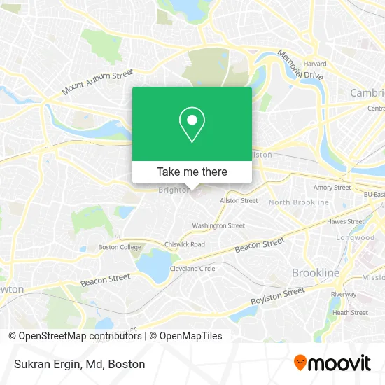
See Sukran Ergin, Md, Boston, on the map
Public Transit to Sukran Ergin, Md in Boston
Wondering how to get to Sukran Ergin, Md in Boston? Moovit helps you find the best way to get to Sukran Ergin, Md with step-by-step directions from the nearest public transit station.
Moovit provides free maps and live directions to help you navigate through your city. View schedules, routes, timetables, and find out how long does it take to get to Sukran Ergin, Md in real time.
Looking for the nearest stop or station to Sukran Ergin, Md? Check out this list of stops closest to your destination: Cambridge St Opp Dustin St; Market St @ Washington St; Washington St Opp Shepard St; Sutherland Road.
Bus: 501, 57, 65, 86, 66.Train: FRAMINGHAM/WORCESTER.Subway: GREEN LINE B.
Want to see if there’s another route that gets you there at an earlier time? Moovit helps you find alternative routes or times. Get directions from and directions to Sukran Ergin, Md easily from the Moovit App or Website.
We make riding to Sukran Ergin, Md easy, which is why over 1.7 million users, including users in Boston, trust Moovit as the best app for public transit. You don’t need to download an individual bus app or train app, Moovit is your all-in-one transit app that helps you find the best bus time or train time available.
For information on prices of bus, subway and train, costs and ride fares to Sukran Ergin, Md, please check the Moovit app.
Use the app to navigate to popular places including to the airport, hospital, stadium, grocery store, mall, coffee shop, school, college, and university.
Sukran Ergin, Md Address: 11 Nevins St Ste 202 street in Boston
- St. Elizabeth's Medical Center,
- Spaulding Outpatient Center Brighton,
- St. Elizabeth's M7,
- SMG Stanton Internal Medicine,
- Dana-Farber Cancer Institute at St. Elizabeth's Medical Center,
- St Elizabeth s Hospital,
- Karen-Jean Poley, MD,
- Lee-Keung George Hsu, MD,
- Brooklyn Pluger, Pa,
- Charles Day MD,
- Lampros Minos, Pa,
- Allan H Ropper MD,
- M. Faisal Khan, MD,
- Victoria Levi, MD,
- Stratus Residences,
- Allston Brighton Community Development Corporation,
- Spi Construction,
- Brighton,
- 228 Washington St Parking,
- Boston Shawarma Restaurant
Places Near Sukran Ergin, Md (Boston)
- Seaport District, Boston,
- Mgm Music Hall, Boston,
- Museum Of Science, Boston,
- Boston Children's Hospital, Boston,
- Leader Bank Pavilion (Leader Bank Pavillion), Boston,
- Wilbur Theatre, Boston,
- Boston Medical Center, Boston,
- Wang Theater, Boston,
- Boston Convention & Exhibition Center, Boston,
- Boston Common, Boston,
- Faneuil Hall, Boston,
- Prudential Center, Boston,
- Quincy Market, Boston,
- Castle Island, Boston,
- Massachusetts General Hospital, Boston,
- Isabella Stewart Gardner Museum, Boston,
- North End, Boston,
- Td Garden, Boston,
- Cheers, Boston,
- House Of Blues, Boston
How to get to popular places in Boston with public transit
Get around Boston by public transit!
Traveling around Boston has never been so easy. See step by step directions as you travel to any attraction, street or major public transit station. View bus and train schedules, arrival times, service alerts and detailed routes on a map, so you know exactly how to get to anywhere in Boston.
When traveling to any destination around Boston use Moovit's Live Directions with Get Off Notifications to know exactly where and how far to walk, how long to wait for your line, and how many stops are left. Moovit will alert you when it's time to get off — no need to constantly re-check whether yours is the next stop.
Wondering how to use public transit in Boston or how to pay for public transit in Boston? Moovit public transit app can help you navigate your way with public transit easily, and at minimum cost. It includes public transit fees, ticket prices, and costs. Looking for a map of Boston public transit lines? Moovit public transit app shows all public transit maps in Boston with all Bus, Train, Subway and Ferry routes and stops on an interactive map.
Boston has 4 transit type(s), including: Bus, Train, Subway and Ferry, operated by several transit agencies, including MBTA, Southeastern Regional Transit Authority, MetroWest Regional Transit Authority, Rhode Island Public Transit Authority, WRTA, Lowell Regional Transit Authority, Merrimack Valley Transit, Montachusett Regional Transit Authority, Cape Cod Regional Transit Authority, Brockton Area Transit Authority, Martha's Vineyard Transit Authority, the WAVE - Nantucket Regional Transit Authority, GATRA, Cape Ann Transportation Authority and Massport