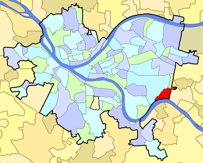
See Swisshelm Park, Pittsburgh, on the map
Directions to Swisshelm Park (Pittsburgh) with public transportation
The following transit lines have routes that pass near Swisshelm Park
Bus:
How to get to Swisshelm Park by Bus?
Click on the Bus route to see step by step directions with maps, line arrival times and updated time schedules.
Bus stations near Swisshelm Park in Pittsburgh
- Aurelius St + Harrison,2 min walk,
- Waterfront Drive + Commonwealth Bank,57 min walk,
- Waterfront Dr + Commonwealth Bank FS,58 min walk,
Bus lines to Swisshelm Park in Pittsburgh
- 71,Inbound-Wilkinsburg,
- P71,Inbound-Downtown,
- 59,Outbound-North Versailles,
- 53,HOMESTEAD PARK,
- 57,HAZELWOOD,
- 61D,MURRAY,
- 64,LAWRENCEVILLE-WATERFRONT,
What are the closest stations to Swisshelm Park?
The closest stations to Swisshelm Park are:
- Aurelius St + Harrison is 164 yards away, 2 min walk.
- Waterfront Drive + Commonwealth Bank is 4905 yards away, 57 min walk.
- Waterfront Dr + Commonwealth Bank FS is 4962 yards away, 58 min walk.
Which Bus lines stop near Swisshelm Park?
These Bus lines stop near Swisshelm Park: 59, 61A, 61B, P71
What’s the nearest bus stop to Swisshelm Park in Pittsburgh?
The nearest bus stop to Swisshelm Park in Pittsburgh is Aurelius St + Harrison. It’s a 2 min walk away.
What time is the first Bus to Swisshelm Park in Pittsburgh?
The 59 is the first Bus that goes to Swisshelm Park in Pittsburgh. It stops nearby at 4:52 AM.
What time is the last Bus to Swisshelm Park in Pittsburgh?
The 64 is the last Bus that goes to Swisshelm Park in Pittsburgh. It stops nearby at 2:12 AM.
How much is the Bus fare to Swisshelm Park?
The Bus fare to Swisshelm Park costs about $2.75.
See Swisshelm Park, Pittsburgh, on the map

Public Transit to Swisshelm Park in Pittsburgh
Wondering how to get to Swisshelm Park in Pittsburgh, United States? Moovit helps you find the best way to get to Swisshelm Park with step-by-step directions from the nearest public transit station.
Moovit provides free maps and live directions to help you navigate through your city. View schedules, routes, timetables, and find out how long does it take to get to Swisshelm Park in real time.
Looking for the nearest stop or station to Swisshelm Park? Check out this list of stops closest to your destination: Aurelius St + Harrison; Waterfront Drive + Commonwealth Bank; Waterfront Dr + Commonwealth Bank FS.
Bus:
Want to see if there’s another route that gets you there at an earlier time? Moovit helps you find alternative routes or times. Get directions from and directions to Swisshelm Park easily from the Moovit App or Website.
We make riding to Swisshelm Park easy, which is why over 1.5 million users, including users in Pittsburgh, trust Moovit as the best app for public transit. You don’t need to download an individual bus app or train app, Moovit is your all-in-one transit app that helps you find the best bus time or train time available.
For information on prices of Bus and Light Rail, costs and ride fares to Swisshelm Park, please check the Moovit app.
Use the app to navigate to popular places including to the airport, hospital, stadium, grocery store, mall, coffee shop, school, college, and university.
Swisshelm Park Address: Uptegraf Street street in Pittsburgh

Attractions near Swisshelm Park
- Goodman St
- R. H. Macy And Co. Fine Jewelry
- Pittsburgh Bagpiper Sean O'Donnell
- Blackhawk St
- The Event Group
- 51 Nevada St
- Parisi Cafe and Italian Market
- The Waterfront
- Margaret Alexander, Pa-C
- Waterfront Surgery Center (JRC 495 Waterfront Dr)
- Monumental Way
- Chipotle
- F.A.T.H.E.R.S. Collaborative Council (FCC)
- Acadia Way
- Gilda St
- Getgo
- Urban Air Trampoline and Adventure Park
- Urban Air Adventure Park
- Holiday Inn Express-Pittsburgh E Waterfront Dr
- UPS Access Point Location
How to get to popular attractions in Pittsburgh with public transit
- Mount Washington, Pittsburgh
- Homewood, Pittsburgh
- Wharton Square, Pittsburgh
- O1 Ross Flyer, Pittsburgh
- Herr's Island Trail Bridge, Pittsburgh
- UPMC Harbor Garden, Pittsburgh
- Heinz Hall, Pittsburgh
- Bidwell Training Center, Pittsburgh
- West Penn Hospital Heliport, Pittsburgh
- Eat'n Park, Pittsburgh
- Gianna Via, Whitehall
- Mckees Rocks, Mckees Rocks
- Mercy Behavioral Health: Reedsdale Center, Pittsburgh
- Giant Eagle
- West Penn Hospital Parking Garage, Pittsburgh
- ridc park
- Alcoma On The Green
- Lincoln-Lemington, Pittsburgh
- Allegheny County Jail, Pittsburgh
- Braddock, Braddock