Szőnyi Út stop - Saturday schedule
| Line | Direction | Time |
|---|---|---|
| 25 | Mexikói Út M | 5:03 |
| 74 | Károly Körút (Astoria M) | 5:11 |
| 32 | Göncz Árpád Városközpont M | 5:19 |
| 74A | Mexikói Út M | 5:24 |
| 74 | Károly Körút (Astoria M) | 5:31 |
| 25 | Mexikói Út M | 5:34 |
| 32 | Göncz Árpád Városközpont M | 5:40 |
| 74A | Mexikói Út M | 5:44 |
| 74 | Károly Körút (Astoria M) | 5:51 |
| 25 | Mexikói Út M | 5:54 |
| 32 | Göncz Árpád Városközpont M | 6:00 |
| 74A | Mexikói Út M | 6:04 |
| 74 | Károly Körút (Astoria M) | 6:11 |
| 25 | Mexikói Út M | 6:14 |
| 74A | Mexikói Út M | 6:19 |
| 32 | Göncz Árpád Városközpont M | 6:20 |
| 74 | Károly Körút (Astoria M) | 6:31 |
| 74A | Mexikói Út M | 6:34 |
| 25 | Mexikói Út M | 6:36 |
| 32 | Göncz Árpád Városközpont M | 6:40 |
| 74A | Mexikói Út M | 6:48 |
| 74 | Károly Körút (Astoria M) | 6:51 |
| 32 | Göncz Árpád Városközpont M | 6:54 |
| 25 | Mexikói Út M | 6:57 |
| 74A | Mexikói Út M | 7:01 |
Directions to Szőnyi Út (Budapest) with public transportation
The following transit lines have routes that pass near Szőnyi Út
How to get to Szőnyi Út by bus?
Click on the bus route to see step by step directions with maps, line arrival times and updated time schedules.
How to get to Szőnyi Út by metro?
Click on the metro route to see step by step directions with maps, line arrival times and updated time schedules.
Bus stops near Szőnyi Út in Budapest
- Teleki Blanka Utca, 6 min walk,
- Kassai Tér, 8 min walk,
- Rákospatak Utca, 11 min walk,
Light Rail stations near Szőnyi Út in Budapest
- Kerékgyártó Utca, 8 min walk,
- Nagy Lajos Király Útja / Czobor Utca, 12 min walk,
Metro stations near Szőnyi Út in Budapest
- Mexikói Út, 13 min walk,
Bus lines to Szőnyi Út in Budapest
- 25, Mexikói Út M,
- 32, Örs Vezér Tere M+H,
- 74, Vakok Intézete,
- 74A, Csáktornya Park,
- 82, Egressy Út / Vezér Utca,
- 225, Rákospalota, Székely Elek Út,
What are the closest stations to Szőnyi Út?
The closest stations to Szőnyi Út are:
- Teleki Blanka Utca is 394 meters away, 6 min walk.
- Kassai Tér is 603 meters away, 8 min walk.
- Kerékgyártó Utca is 627 meters away, 8 min walk.
- Rákospatak Utca is 825 meters away, 11 min walk.
- Nagy Lajos Király Útja / Czobor Utca is 891 meters away, 12 min walk.
- Mexikói Út is 987 meters away, 13 min walk.
Which bus line stops near Szőnyi Út?
32
Which metro line stops near Szőnyi Út?
M1
What’s the nearest light rail station to Szőnyi Út in Budapest?
The nearest light rail station to Szőnyi Út in Budapest is Kerékgyártó Utca. It’s a 8 min walk away.
What’s the nearest metro station to Szőnyi Út in Budapest?
The nearest metro station to Szőnyi Út in Budapest is Mexikói Út. It’s a 13 min walk away.
What’s the nearest bus stop to Szőnyi Út in Budapest?
The nearest bus stop to Szőnyi Út in Budapest is Teleki Blanka Utca. It’s a 6 min walk away.
What time is the first metro to Szőnyi Út in Budapest?
The M1 is the first metro that goes to Szőnyi Út in Budapest. It stops nearby at 4:32 AM.
What time is the last metro to Szőnyi Út in Budapest?
The M1 is the last metro that goes to Szőnyi Út in Budapest. It stops nearby at 11:57 PM.
What time is the first bus to Szőnyi Út in Budapest?
The 973 is the first bus that goes to Szőnyi Út in Budapest. It stops nearby at 3:05 AM.
What time is the last bus to Szőnyi Út in Budapest?
The 973 is the last bus that goes to Szőnyi Út in Budapest. It stops nearby at 3:46 AM.
See Szőnyi Út, Budapest, on the map
Public transit to Szőnyi Út stop (ID: 008241) in Budapest
Looking for directions to Szőnyi Út in Budapest, Hungary?
Download the Moovit App to find the current schedule and step-by-step directions for Bus, Metro or Light Rail routes that pass through Szőnyi Út.
Looking for the nearest stops closest to Szőnyi Út ? Check out this list of closest stops to your destination: Teleki Blanka Utca; Kassai Tér; Kerékgyártó Utca; Rákospatak Utca; Nagy Lajos Király Útja / Czobor Utca; Mexikói Út.
Bus: 32, 25, 74, 74A, 82, 225.Metro: M1.
We make riding on public transit to Szőnyi Út easy, which is why over 1.5 million users, including users in Budapest trust Moovit as the best app for public transit.
Use the app to navigate to popular places including to the airport, hospital, stadium, grocery store, mall, coffee shop, school, college, and university.
Szőnyi Út stop’s code is 008241
The first line to this stop is 25, at 5:03, and the last line is 32 at 4:58.
Ógyalla köz, Budapest, Hungary
This stop serves BKK’s lines
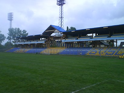
Szőnyi úti Stadion is a sports stadium in Zugló, Budapest, Hungary. The stadium is home to the association football side BVSC Budapest. The stadium has a capacity of 12,000.Wiki
Metro station near Szőnyi Út
Popular public transit stations in Budapest
Get around Budapest by public transit!
Traveling around Budapest has never been so easy. See step by step directions as you travel to any attraction, street or major public transit station. View bus and train schedules, arrival times, service alerts and detailed routes on a map, so you know exactly how to get to anywhere in Budapest.
When traveling to any destination around Budapest use Moovit's Live Directions with Get Off Notifications to know exactly where and how far to walk, how long to wait for your line, and how many stops are left. Moovit will alert you when it's time to get off — no need to constantly re-check whether yours is the next stop.
Wondering how to use public transit in Budapest or how to pay for public transit in Budapest? Moovit public transit app can help you navigate your way with public transit easily, and at minimum cost. It includes public transit fees, ticket prices, and costs. Looking for a map of Budapest public transit lines? Moovit public transit app shows all public transit maps in Budapest with all bus, metro or light rail routes and stops on an interactive map.
Budapest has 3 transit type(s), including: bus, metro or light rail, operated by several transit agencies, including BKK, BKK, BKK, BKK and MÁV-HÉV