Directions to T J Collins (Needham) with public transportation
The following transit lines have routes that pass near T J Collins
 Bus: 52, 59, NEEDHAM LINE SHUTTLE, NEEDHAM LINE SHUTTLE.
- Train: NEEDHAM.
- Subway: GREEN LINE D.
How to get to T J Collins by bus?
Click on the bus route to see step by step directions with maps, line arrival times and updated time schedules.
From Georgetown, Massachusetts, Boston
154 minFrom Arnold Arboretum, Boston
110 minFrom Courtyard by Marriott Brookline, Brookline
82 minFrom Citizens Bank Opera House, Boston
67 minFrom Allston, Boston
68 minFrom Brighton Music Hall, Boston
67 minFrom Coolidge Corner Theatre, Brookline
81 minFrom Forest Hills Station MBTA, Boston
89 minFrom Hampton Inn & Suites-Hampton Watertown Boston (Hampton Inn & Suites Watertown Boston), Watertown Town
52 min
How to get to T J Collins by train?
Click on the train route to see step by step directions with maps, line arrival times and updated time schedules.
From Georgetown, Massachusetts, Boston
127 minFrom Arnold Arboretum, Boston
53 minFrom Citizens Bank Opera House, Boston
97 minFrom Allston, Boston
94 minFrom Brighton Music Hall, Boston
98 minFrom Legacy Place, Dedham
77 minFrom Coolidge Corner Theatre, Brookline
104 minFrom Forest Hills Station MBTA, Boston
43 min
How to get to T J Collins by subway?
Click on the subway route to see step by step directions with maps, line arrival times and updated time schedules.
Bus stops near T J Collins in Needham
Train station near T J Collins in Needham
- Needham Heights, 7 min walk,VIEW
Subway station near T J Collins in Needham
- Waban, 43 min walk,VIEW
Bus lines to T J Collins in Needham
What are the closest stations to T J Collins?
The closest stations to T J Collins are:
- Highland Ave @ Mark Lee Rd is 529 yards away, 7 min walk.
- Needham Heights is 584 yards away, 7 min walk.
- Waban is 3599 yards away, 43 min walk.
Which bus lines stop near T J Collins?
These bus lines stop near T J Collins: 52, 59.
Which train line stops near T J Collins?
NEEDHAM (#625 | Needham Heights)
Which subway line stops near T J Collins?
GREEN LINE D (Riverside)
What’s the nearest train station to T J Collins in Needham?
The nearest train station to T J Collins in Needham is Needham Heights. It’s a 7 min walk away.
What’s the nearest bus station to T J Collins in Needham?
The nearest bus station to T J Collins in Needham is Highland Ave @ Mark Lee Rd. It’s a 7 min walk away.
What time is the first subway to T J Collins in Needham?
The GREEN LINE D is the first subway that goes to T J Collins in Needham. It stops nearby at 4:48 AM.
What time is the last subway to T J Collins in Needham?
The GREEN LINE D is the last subway that goes to T J Collins in Needham. It stops nearby at 2:44 AM.
What time is the first train to T J Collins in Needham?
The NEEDHAM is the first train that goes to T J Collins in Needham. It stops nearby at 7:05 AM.
What time is the last train to T J Collins in Needham?
The NEEDHAM is the last train that goes to T J Collins in Needham. It stops nearby at 6:38 PM.
What time is the first bus to T J Collins in Needham?
The 59 is the first bus that goes to T J Collins in Needham. It stops nearby at 6:25 AM.
What time is the last bus to T J Collins in Needham?
The 59 is the last bus that goes to T J Collins in Needham. It stops nearby at 7:58 PM.
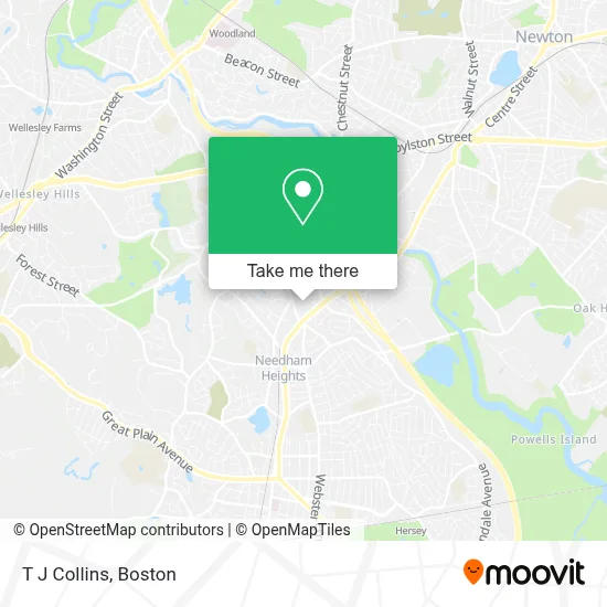
See T J Collins, Needham, on the map
Public Transit to T J Collins in Needham
Wondering how to get to T J Collins in Needham? Moovit helps you find the best way to get to T J Collins with step-by-step directions from the nearest public transit station.
Moovit provides free maps and live directions to help you navigate through your city. View schedules, routes, timetables, and find out how long does it take to get to T J Collins in real time.
Looking for the nearest stop or station to T J Collins? Check out this list of stops closest to your destination: Highland Ave @ Mark Lee Rd; Needham Heights; Waban.
Bus: 52, 59, NEEDHAM LINE SHUTTLE, NEEDHAM LINE SHUTTLE.Train: NEEDHAM.Subway: GREEN LINE D.
Want to see if there’s another route that gets you there at an earlier time? Moovit helps you find alternative routes or times. Get directions from and directions to T J Collins easily from the Moovit App or Website.
We make riding to T J Collins easy, which is why over 1.7 million users, including users in Needham, trust Moovit as the best app for public transit. You don’t need to download an individual bus app or train app, Moovit is your all-in-one transit app that helps you find the best bus time or train time available.
For information on prices of bus, train and subway, costs and ride fares to T J Collins, please check the Moovit app.
Use the app to navigate to popular places including to the airport, hospital, stadium, grocery store, mall, coffee shop, school, college, and university.
T J Collins Address: 40 Arbor St street in Needham
- JTC Printing,
- Herbert Geller,
- Charles River Media Group,
- Newscenter 5 (WCVB-TV),
- Locksmith Club,
- Carter Preschool,
- Russian Cultural Center Lukomorie,
- Needham Heights,
- Rodman Insurance Agency,
- Mac Lean Carpet Cleaners,
- Belmont Landscape & Tree,
- GF Spraque,
- Floor Data Corporation,
- USPS,
- Travel To Tenerife,
- Mass Discount Fuel,
- WCVB-TV Channel 5,
- Rodgers Organs of New England,
- Outdoor Maintenance Company,
- Garment Machinery Company, Inc.
Places Near T J Collins (Needham)
- Boston Convention & Exhibition Center, Boston,
- Faneuil Hall, Boston,
- Boston Medical Center, Boston,
- North End, Boston,
- Massachusetts General Hospital, Boston,
- Td Garden, Boston,
- Museum Of Science, Boston,
- Castle Island, Boston,
- Cheers, Boston,
- House Of Blues, Boston,
- Boston Children's Hospital, Boston,
- Leader Bank Pavilion (Leader Bank Pavillion), Boston,
- Prudential Center, Boston,
- Boston Common, Boston,
- Isabella Stewart Gardner Museum, Boston,
- Quincy Market, Boston,
- Seaport District, Boston,
- Wilbur Theatre, Boston,
- Mgm Music Hall, Boston,
- Wang Theater, Boston
How to get to popular places in Boston with public transit
Get around Needham by public transit!
Traveling around Needham has never been so easy. See step by step directions as you travel to any attraction, street or major public transit station. View bus and train schedules, arrival times, service alerts and detailed routes on a map, so you know exactly how to get to anywhere in Needham.
When traveling to any destination around Needham use Moovit's Live Directions with Get Off Notifications to know exactly where and how far to walk, how long to wait for your line, and how many stops are left. Moovit will alert you when it's time to get off — no need to constantly re-check whether yours is the next stop.
Wondering how to use public transit in Needham or how to pay for public transit in Needham? Moovit public transit app can help you navigate your way with public transit easily, and at minimum cost. It includes public transit fees, ticket prices, and costs. Looking for a map of Needham public transit lines? Moovit public transit app shows all public transit maps in Needham with all Bus, Train, Subway and Ferry routes and stops on an interactive map.
Boston has 4 transit type(s), including: Bus, Train, Subway and Ferry, operated by several transit agencies, including MBTA, Southeastern Regional Transit Authority, MetroWest Regional Transit Authority, Rhode Island Public Transit Authority, WRTA, Lowell Regional Transit Authority, Merrimack Valley Transit, Montachusett Regional Transit Authority, Cape Cod Regional Transit Authority, Brockton Area Transit Authority, Martha's Vineyard Transit Authority, the WAVE - Nantucket Regional Transit Authority, GATRA, Cape Ann Transportation Authority and Massport