See The Greene Town Center, Beavercreek, on the map
Directions to The Greene Town Center (Beavercreek) with public transportation
The following transit lines have routes that pass near The Greene Town Center
 Bus:
Bus:
How to get to The Greene Town Center by bus?
Click on the bus route to see step by step directions with maps, line arrival times and updated time schedules.
Bus stations near The Greene Town Center in Beavercreek
- Dorothy @ Stroop,1 min walk,
Bus lines to The Greene Town Center in Beavercreek
- 28,Kettering Via Dorothy Ln,
What are the closest stations to The Greene Town Center?
The closest stations to The Greene Town Center are:
- Dorothy @ Stroop is 37 yards away, 1 min walk.
Which bus line stops near The Greene Town Center?
28
What’s the nearest bus stop to The Greene Town Center in Beavercreek?
The nearest bus stop to The Greene Town Center in Beavercreek is Dorothy @ Stroop. It’s a 1 min walk away.
What time is the first bus to The Greene Town Center in Beavercreek?
The 28 is the first bus that goes to The Greene Town Center in Beavercreek. It stops nearby at 6:00 AM.
What time is the last bus to The Greene Town Center in Beavercreek?
The 28 is the last bus that goes to The Greene Town Center in Beavercreek. It stops nearby at 11:45 PM.
How much is the bus fare to The Greene Town Center?
The bus fare to The Greene Town Center costs about $2.00.
See The Greene Town Center, Beavercreek, on the map
Public Transit to The Greene Town Center in Beavercreek
Wondering how to get to The Greene Town Center in Beavercreek, United States? Moovit helps you find the best way to get to The Greene Town Center with step-by-step directions from the nearest public transit station.
Moovit provides free maps and live directions to help you navigate through your city. View schedules, routes, timetables, and find out how long does it take to get to The Greene Town Center in real time.
Looking for the nearest stop or station to The Greene Town Center? Check out this list of stops closest to your destination: Dorothy @ Stroop.
Bus:
Want to see if there’s another route that gets you there at an earlier time? Moovit helps you find alternative routes or times. Get directions from and directions to The Greene Town Center easily from the Moovit App or Website.
We make riding to The Greene Town Center easy, which is why over 1.5 million users, including users in Beavercreek, trust Moovit as the best app for public transit. You don’t need to download an individual bus app or train app, Moovit is your all-in-one transit app that helps you find the best bus time or train time available.
For information on prices of bus, costs and ride fares to The Greene Town Center, please check the Moovit app.
Use the app to navigate to popular places including to the airport, hospital, stadium, grocery store, mall, coffee shop, school, college, and university.
The Greene Town Center Address: Cedar Park Drive street in Beavercreek
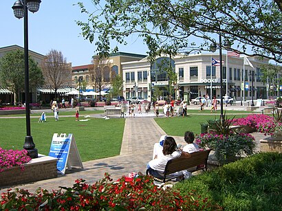
Attractions near The Greene Town Center
Take A Break,SEPHORA,Charlotte Tilbury,Steiner & Associates,WWP Holiday Photos 568,PCS Cash Back,Pest Control Services Chemotherapy,Celeste Kniess Realtor - Re / Max Victory,Sarah Back - Re / Max Victory + Affiliates,The Greene,Roland Gazaille do,Pearle,Select Comfort,The Green Town Center - Cinema Lot,Dripseason937,Compass Financial Group, Inc.,Morgan Team Realtors,Stipp, Sherry, Agt,Birkenstock,The Fountains at the GreeneHow to get to popular attractions in Beavercreek with public transit
I-675 EXIT 7, Centerville,Stebbins High School, Riverside,Rose Music Center at the Heights, Huber Heights,I-75 Exit 59 - Wyse Rd Benchwood Rd,Rt 35W Woodman Exit, Riverside,City Of Oakwood, Oakwood,Meadowdale High School,I-70 Exit 33 & I-75 Exit 61,I-675 Exit 4,Benjamin and Marian Schuster Heart Hospital, Kettering,Dayton VA Medical Center, Dayton,RTA Route 1 Drexel via W. 3rd, Drexel,BBW.com, Kettering,Walmart Supercenter, Huber Heights,ASPM, Vandalia,RTA: Northwest Hub, Trotwood,Miller Lane,Gate 22B WPAFB, Wright-Patterson Afb,741 & 725, Miamisburg,Walmart SupercenterGet around Beavercreek by public transit!
Traveling around Beavercreek has never been so easy. See step by step directions as you travel to any attraction, street or major public transit station. View bus and train schedules, arrival times, service alerts and detailed routes on a map, so you know exactly how to get to anywhere in Beavercreek.
When traveling to any destination around Beavercreek use Moovit's Live Directions with Get Off Notifications to know exactly where and how far to walk, how long to wait for your line, and how many stops are left. Moovit will alert you when it's time to get off — no need to constantly re-check whether yours is the next stop.
Wondering how to use public transit in Beavercreek or how to pay for public transit in Beavercreek? Moovit public transit app can help you navigate your way with public transit easily, and at minimum cost. It includes public transit fees, ticket prices, and costs. Looking for a map of Beavercreek public transit lines? Moovit public transit app shows all public transit maps in Beavercreek with all bus routes and stops on an interactive map.
Beavercreek has 1 transit type(s), including: bus, operated by several transit agencies, including Greater Dayton RTA, FlixBus-us and Greyhound-us