Directions to The IV Hub (Medford) with public transportation
The following transit lines have routes that pass near The IV Hub
 Bus: 100, 101, 95.
- Train: HAVERHILL, ORANGE LINE.
- Subway: ORANGE LINE, GREEN LINE B, GREEN LINE C, GREEN LINE E.
How to get to The IV Hub by bus?
Click on the bus route to see step by step directions with maps, line arrival times and updated time schedules.
From Boston Black Falcon Cruise Terminal, Boston
60 minFrom St. Elizabeth's, Boston
99 minFrom Dana Farber Cancer Institute, Boston
70 minFrom Black Falcon Cruise Terminal, Boston
71 minFrom Embassy Suites-Boston, Boston
68 minFrom Mass Eye & Ear, Boston
89 minFrom TownePlace Suites Boston Logan Airport/Chelsea, Chelsea
54 minFrom Boston University Henry M. Goldman School of Dental Medicine, Boston
100 minFrom Puttshack, Boston
61 minFrom Kendall Square, Cambridge
66 min
How to get to The IV Hub by train?
Click on the train route to see step by step directions with maps, line arrival times and updated time schedules.
How to get to The IV Hub by subway?
Click on the subway route to see step by step directions with maps, line arrival times and updated time schedules.
From St. Elizabeth's, Boston
84 minFrom Embassy Suites-Boston, Boston
56 minFrom Mass Eye & Ear, Boston
69 minFrom TownePlace Suites Boston Logan Airport/Chelsea, Chelsea
65 minFrom Boston University Henry M. Goldman School of Dental Medicine, Boston
64 minFrom Puttshack, Boston
57 minFrom Kendall Square, Cambridge
57 min
Bus stops near The IV Hub in Medford
Train station near The IV Hub in Medford
- Oak Grove, 36 min walk,VIEW
Subway station near The IV Hub in Medford
- Medford/Tufts Station, 45 min walk,VIEW
Bus lines to The IV Hub in Medford
What are the closest stations to The IV Hub?
The closest stations to The IV Hub are:
- Salem St @ Fellsway Garage is 164 yards away, 3 min walk.
- Fellsway W @ Salem St is 187 yards away, 3 min walk.
- Oak Grove is 2999 yards away, 36 min walk.
- Medford/Tufts Station is 3751 yards away, 45 min walk.
Which bus lines stop near The IV Hub?
These bus lines stop near The IV Hub: 100, 101.
Which train line stops near The IV Hub?
HAVERHILL (#229 | Haverhill)
Which subway line stops near The IV Hub?
ORANGE LINE (Oak Grove)
What’s the nearest bus station to The IV Hub in Medford?
The nearest bus stations to The IV Hub in Medford are Salem St @ Fellsway Garage and Fellsway W @ Salem St. The closest one is a 3 min walk away.
What time is the first subway to The IV Hub in Medford?
The GREEN LINE E is the first subway that goes to The IV Hub in Medford. It stops nearby at 4:53 AM.
What time is the last subway to The IV Hub in Medford?
The GREEN LINE E is the last subway that goes to The IV Hub in Medford. It stops nearby at 2:41 AM.
What time is the first train to The IV Hub in Medford?
The HAVERHILL is the first train that goes to The IV Hub in Medford. It stops nearby at 5:35 AM.
What time is the last train to The IV Hub in Medford?
The HAVERHILL is the last train that goes to The IV Hub in Medford. It stops nearby at 11:53 PM.
What time is the first bus to The IV Hub in Medford?
The 101 is the first bus that goes to The IV Hub in Medford. It stops nearby at 4:51 AM.
What time is the last bus to The IV Hub in Medford?
The 101 is the last bus that goes to The IV Hub in Medford. It stops nearby at 1:32 AM.
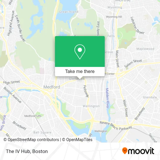
See The IV Hub, Medford, on the map
Public Transit to The IV Hub in Medford
Wondering how to get to The IV Hub in Medford? Moovit helps you find the best way to get to The IV Hub with step-by-step directions from the nearest public transit station.
Moovit provides free maps and live directions to help you navigate through your city. View schedules, routes, timetables, and find out how long does it take to get to The IV Hub in real time.
Looking for the nearest stop or station to The IV Hub? Check out this list of stops closest to your destination: Salem St @ Fellsway Garage; Fellsway W @ Salem St; Oak Grove; Medford/Tufts Station.
Bus: 100, 101, 95.Train: HAVERHILL, ORANGE LINE.Subway: ORANGE LINE, GREEN LINE B, GREEN LINE C, GREEN LINE E.
Want to see if there’s another route that gets you there at an earlier time? Moovit helps you find alternative routes or times. Get directions from and directions to The IV Hub easily from the Moovit App or Website.
We make riding to The IV Hub easy, which is why over 1.7 million users, including users in Medford, trust Moovit as the best app for public transit. You don’t need to download an individual bus app or train app, Moovit is your all-in-one transit app that helps you find the best bus time or train time available.
For information on prices of bus, subway and train, costs and ride fares to The IV Hub, please check the Moovit app.
Use the app to navigate to popular places including to the airport, hospital, stadium, grocery store, mall, coffee shop, school, college, and university.
The IV Hub Address: 469 Salem St street in Medford
- Blink Fitness - Medford,
- STARBUCKS,
- Cement Shoes,
- MBTA Fellsway Bus Garage,
- Blink Fitness,
- Target,
- Cleide Alves Brands,
- Insurance Associates,
- T-Mobile,
- Auto Locksmith LTD,
- Studio Hair 26,
- DUNKIN',
- Kwench Juice Cafe,
- Massage Nirvana,
- Heritage Florist,
- Medford Firefighte,
- RT-60,
- Styled by BB Riah,
- Morrison Park,
- R & L Auto Repair
Places Near The IV Hub (Medford)
- Wilbur Theatre, Boston,
- Boston Convention & Exhibition Center, Boston,
- Castle Island, Boston,
- Cheers, Boston,
- Boston Common, Boston,
- Isabella Stewart Gardner Museum, Boston,
- Museum Of Science, Boston,
- Td Garden, Boston,
- House Of Blues, Boston,
- Boston Medical Center, Boston,
- North End, Boston,
- Quincy Market, Boston,
- Faneuil Hall, Boston,
- Prudential Center, Boston,
- Mgm Music Hall, Boston,
- Seaport District, Boston,
- Boston Children's Hospital, Boston,
- Wang Theater, Boston,
- Massachusetts General Hospital, Boston,
- Leader Bank Pavilion (Leader Bank Pavillion), Boston
How to get to popular places in Boston with public transit
Get around Medford by public transit!
Traveling around Medford has never been so easy. See step by step directions as you travel to any attraction, street or major public transit station. View bus and train schedules, arrival times, service alerts and detailed routes on a map, so you know exactly how to get to anywhere in Medford.
When traveling to any destination around Medford use Moovit's Live Directions with Get Off Notifications to know exactly where and how far to walk, how long to wait for your line, and how many stops are left. Moovit will alert you when it's time to get off — no need to constantly re-check whether yours is the next stop.
Wondering how to use public transit in Medford or how to pay for public transit in Medford? Moovit public transit app can help you navigate your way with public transit easily, and at minimum cost. It includes public transit fees, ticket prices, and costs. Looking for a map of Medford public transit lines? Moovit public transit app shows all public transit maps in Medford with all Bus, Train, Subway and Ferry routes and stops on an interactive map.
Boston has 4 transit type(s), including: Bus, Train, Subway and Ferry, operated by several transit agencies, including MBTA, Southeastern Regional Transit Authority, MetroWest Regional Transit Authority, Rhode Island Public Transit Authority, WRTA, Lowell Regional Transit Authority, Merrimack Valley Transit, Montachusett Regional Transit Authority, Cape Cod Regional Transit Authority, Brockton Area Transit Authority, Martha's Vineyard Transit Authority, the WAVE - Nantucket Regional Transit Authority, GATRA, Cape Ann Transportation Authority and Massport