How to get to Titlemax by bus?
Click on the bus route to see step by step directions with maps, line arrival times and updated time schedules.
From Foreign Service Institute, Arlington County
82 minFrom Nova- Alexandria Campus, Alexandria
58 minFrom Naval Research Lab, Washington
97 minFrom Navy Lodge, Washington
98 minFrom Franconia-Springfield Metro Station, Fairfax County
45 minFrom State Dept Annex SA-15, Arlington County
80 minFrom National Guard Bureau, Arlington County
76 minFrom The Pentagon, Hall Of Heroes, Arlington County
72 minFrom Long Bridge Park, Arlington County
75 minFrom Ballou High School, Washington
92 min
How to get to Titlemax by metro?
Click on the metro route to see step by step directions with maps, line arrival times and updated time schedules.
Bus stops near Titlemax in Fairfax County
Metro stations near Titlemax in Fairfax County
Train station near Titlemax in Fairfax County
- Alexandria, 57 min walk,VIEW
Bus lines to Titlemax in Fairfax County
What are the closest stations to Titlemax?
The closest stations to Titlemax are:
- Richmond Hwy @ Franklin St is 138 yards away, 2 min walk.
- Richmond Hwy @ Regan St is 161 yards away, 3 min walk.
- S Kings Hwy @ Furman La is 328 yards away, 5 min walk.
- Richmond Hwy+S Kings Hwy is 335 yards away, 5 min walk.
- Richmond Hwy @ South Kings Hwy is 350 yards away, 5 min walk.
- Huntington is 2901 yards away, 34 min walk.
- Alexandria is 4855 yards away, 57 min walk.
- King Street-Old Town is 5002 yards away, 59 min walk.
Which bus lines stop near Titlemax?
These bus lines stop near Titlemax: 151, 162, 171, F1X.
Which metro line stops near Titlemax?
YELLOW (Huntington)
What’s the nearest bus station to Titlemax in Fairfax County?
The nearest bus station to Titlemax in Fairfax County is Richmond Hwy @ Franklin St. It’s a 2 min walk away.
What time is the first metro to Titlemax in Fairfax County?
The YELLOW is the first metro that goes to Titlemax in Fairfax County. It stops nearby at 5:00 AM.
What time is the last metro to Titlemax in Fairfax County?
The YELLOW is the last metro that goes to Titlemax in Fairfax County. It stops nearby at 12:39 AM.
What time is the first train to Titlemax in Fairfax County?
The SILVER METEOR is the first train that goes to Titlemax in Fairfax County. It stops nearby at 5:54 AM.
What time is the last train to Titlemax in Fairfax County?
The SILVER METEOR is the last train that goes to Titlemax in Fairfax County. It stops nearby at 5:54 AM.
What time is the first bus to Titlemax in Fairfax County?
The 171 is the first bus that goes to Titlemax in Fairfax County. It stops nearby at 4:01 AM.
What time is the last bus to Titlemax in Fairfax County?
The 171 is the last bus that goes to Titlemax in Fairfax County. It stops nearby at 1:48 AM.
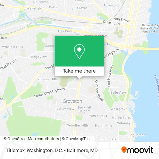
See Titlemax, Fairfax County, on the map
Public Transit to Titlemax in Fairfax County
Wondering how to get to Titlemax in Fairfax County? Moovit helps you find the best way to get to Titlemax with step-by-step directions from the nearest public transit station.
Moovit provides free maps and live directions to help you navigate through your city. View schedules, routes, timetables, and find out how long does it take to get to Titlemax in real time.
Looking for the nearest stop or station to Titlemax? Check out this list of stops closest to your destination: Richmond Hwy @ Franklin St; Richmond Hwy @ Regan St; S Kings Hwy @ Furman La; Richmond Hwy+S Kings Hwy; Richmond Hwy @ South Kings Hwy; Huntington; Alexandria; King Street-Old Town.
Bus: 151, 162, 171, F1X, 161, 152.Train: CARDINAL, CAROLINIAN, CRESCENT, FLORIDIAN, NORTHEAST REGIONAL.Metro: YELLOW, BLUE.
Want to see if there’s another route that gets you there at an earlier time? Moovit helps you find alternative routes or times. Get directions from and directions to Titlemax easily from the Moovit App or Website.
We make riding to Titlemax easy, which is why over 1.5 million users, including users in Fairfax County, trust Moovit as the best app for public transit. You don’t need to download an individual bus app or train app, Moovit is your all-in-one transit app that helps you find the best bus time or train time available.
For information on prices of bus and metro, costs and ride fares to Titlemax, please check the Moovit app.
Use the app to navigate to popular places including to the airport, hospital, stadium, grocery store, mall, coffee shop, school, college, and university.
Titlemax Address: 6410 Richmond Hwy Alexandria, VA 22306 street in Fairfax County
- Clean Smart Cleaners,
- Torch Salon Gallery,
- Las Veguitas Restaurant (Las Vegas Restaurant),
- M.E. Flow,
- Fairfield Inn & Suites by Marriott Alexandria,
- Uncle C's Chicken & Waffles,
- Milk & Honey Cafe Kings Crossing,
- Walmart Alexandria Supercenter,
- VCA,
- Target Alexandria Hybla Valley,
- Rise N Shine Carpet Cleaning,
- Capital Crossfit (Capital Mma & Elite Fitness),
- STARBUCKS,
- Wendy's,
- Kong Dog,
- Locksmith Vehicle,
- Little Steps Daycare,
- Credit Union 1,
- My Lock Locksmith,
- Beacon Hill Road Emergency Homeless Shelter
Places Near Titlemax (Fairfax County)
- Westfield Montgomery Mall, Montgomery County,
- Marriott Marquis Washington, DC, Washington,
- M&T Bank Stadium, Baltimore,
- Washington DC VA Medical Center, Washington,
- PG Mall, Prince George's County,
- Basilica of the National Shrine, Washington,
- National Museum of African American History and Culture, Washington,
- Warner Theatre, Washington,
- Rock Creek Tennis Center, Washington,
- Sibley Memorial Hospital, Washington,
- Museum Of The Bible, Washington,
- Georgetown, Washington,
- Amazon Hq2, Arlington County,
- Camden Yards, Baltimore,
- Capital One Arena, Washington,
- Washington National Cathedral, Washington,
- The Anthem, Washington,
- Pennsylvania Ave NW (3rd st and pennsylvania), Washington,
- National Zoo, Washington,
- National Theatre, Washington
How to get to popular places in Washington, D.C. - Baltimore, MD with public transit
Get around Fairfax County by public transit!
Traveling around Fairfax County has never been so easy. See step by step directions as you travel to any attraction, street or major public transit station. View bus and train schedules, arrival times, service alerts and detailed routes on a map, so you know exactly how to get to anywhere in Fairfax County.
When traveling to any destination around Fairfax County use Moovit's Live Directions with Get Off Notifications to know exactly where and how far to walk, how long to wait for your line, and how many stops are left. Moovit will alert you when it's time to get off — no need to constantly re-check whether yours is the next stop.
Wondering how to use public transit in Fairfax County or how to pay for public transit in Fairfax County? Moovit public transit app can help you navigate your way with public transit easily, and at minimum cost. It includes public transit fees, ticket prices, and costs. Looking for a map of Fairfax County public transit lines? Moovit public transit app shows all public transit maps in Fairfax County with all Bus, Train, Metro, Light Rail and Ferry routes and stops on an interactive map.
Washington, D.C. - Baltimore, MD has 5 transit type(s), including: Bus, Train, Metro, Light Rail and Ferry, operated by several transit agencies, including WMATA, Montgomery County Ride On, Fairfax Connector, TheBus, PRTC, DASH - Alexandria, Arlington Transit (ART), RTA of Central Maryland, MDOT MTA, MDOT MTA Light RailLink, MDOT MTA Commuter Bus, MDOT MTA Local Bus, FXBGO!, Virginia Railway Express (VRE) and MARC