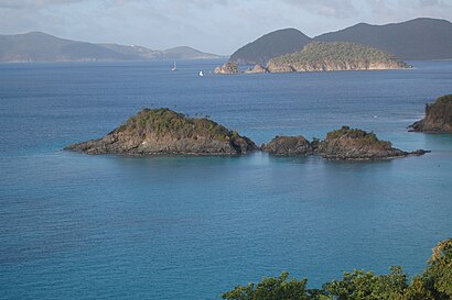
See Trunk Cay, Saint John, on the map
Directions to Trunk Cay (Saint John) with public transportation
The following transit lines have routes that pass near Trunk Cay
 Bus:
Bus:
Which bus line stops near Trunk Cay?
108
See Trunk Cay, Saint John, on the map
Public Transit to Trunk Cay in Saint John
Wondering how to get to Trunk Cay in Saint John, US Virgin Islands? Moovit helps you find the best way to get to Trunk Cay with step-by-step directions from the nearest public transit station.
Moovit provides free maps and live directions to help you navigate through your city. View schedules, routes, timetables, and find out how long does it take to get to Trunk Cay in real time.
Bus:
Want to see if there’s another route that gets you there at an earlier time? Moovit helps you find alternative routes or times. Get directions from and directions to Trunk Cay easily from the Moovit App or Website.
We make riding to Trunk Cay easy, which is why over 1.5 million users, including users in Saint John, trust Moovit as the best app for public transit. You don’t need to download an individual bus app or train app, Moovit is your all-in-one transit app that helps you find the best bus time or train time available.
For information on prices of bus and ferry, costs and ride fares to Trunk Cay, please check the Moovit app.
Use the app to navigate to popular places including to the airport, hospital, stadium, grocery store, mall, coffee shop, school, college, and university.
Location: Saint John, U.S. Virgin Islands
Attractions near Trunk Cay
Trunk Cay,Trunk Bay Gift Shop,Trunk Bay,Trunk Beach,Number 1 of Trunk Bay,Scenic Overlook of Trunk Bay,Jumbie Beach,Trunk Bay,Dennis Bay Historic District,Oppenheimer Beach,Peter Bay Beach,Perkins Cay,Peace Hill Ruins,Cinnamon Bay,Magic Moments Luxury Excursions,Peter Peak,Peter Peak (290m),Oppenheimer Beach,Cinnamon Bay Campground,Little Cinnamon BayHow to get to popular attractions in Saint John with public transit
Lime Out, Saint John,Vibir-Excise Tax, Saint Thomas,Ivy's Ice Cream, Saint Croix,Surf N' Turf Bistro, Saint Thomas,Island Stones, Saint John,Almeric L Christian Federal Building and Courthouse, Saint Croix,Vitelcom Cellular in, Saint Croix,Crystal Cove Beach Resort on Sapphire Bay, Saint Thomas,Coral Harbor, Saint John,Waterbase, Saint John,Fantasia, Saint John,Brooks Bar And Restaurant, Saint Thomas,Seven Wonders and Diamond Palace Gift Shop, Saint Thomas,Jumbies, Saint Thomas,Louis Vuitton St Thomas, Saint Thomas,Charlotte Amalie, Saint Thomas,The Beautiful Artist Makeup Studio & Brow Bar, Saint Croix,Husband Day Care at Rum Island Pub, Saint Thomas,Black Sand Bistro, Saint John,Ted's Supper Club, Saint JohnGet around Saint John by public transit!
Traveling around Saint John has never been so easy. See step by step directions as you travel to any attraction, street or major public transit station. View bus and train schedules, arrival times, service alerts and detailed routes on a map, so you know exactly how to get to anywhere in Saint John.
When traveling to any destination around Saint John use Moovit's Live Directions with Get Off Notifications to know exactly where and how far to walk, how long to wait for your line, and how many stops are left. Moovit will alert you when it's time to get off — no need to constantly re-check whether yours is the next stop.
Wondering how to use public transit in Saint John or how to pay for public transit in Saint John? Moovit public transit app can help you navigate your way with public transit easily, and at minimum cost. It includes public transit fees, ticket prices, and costs. Looking for a map of Saint John public transit lines? Moovit public transit app shows all public transit maps in Saint John with all bus or ferry routes and stops on an interactive map.
Saint John has 2 transit type(s), including: bus or ferry, operated by several transit agencies, including Vitran - Virgin Islands Transit, Vitran - Virgin Islands Transit, Water Island Ferry, Inter Island Boat Services, Love City Car Ferries and Frenchman's Cove Ferry