Directions to Umass Public History Program (Boston) with public transportation
The following transit lines have routes that pass near Umass Public History Program
 Bus: B43, GREYHOUND US0256S, PETER PAN, 46, 30.
How to get to Umass Public History Program by bus?
Click on the bus route to see step by step directions with maps, line arrival times and updated time schedules.
From Quinsigamond Community College, Worcester
175 minFrom South High Community School, Worcester
254 minFrom Palladium, Worcester
162 minFrom Registry Of Motor Vehicles (Rmv) Branch Office, Worcester
161 minFrom Worcester, MA, Worcester
157 minFrom Foxwoods, Worcester
187 minFrom Gardner, MA, Gardner
156 min
Bus stops near Umass Public History Program in Boston
Bus lines to Umass Public History Program in Boston
- 30, North Amherst / Old Belchertown Rd,VIEW
- 31, Sunderland / South Amherst,VIEW
- 33, Puffers Pond / Stop and Shop,VIEW
- 45, Belchertown Center / UMass,VIEW
- 38NS, Mount Holyoke / UMass - No School,VIEW
- PG, Pelham-Greenfield,VIEW
- UMG, To/From Bus Garage,VIEW
- 46, Whately Park & Ride Via S. Deerfield,VIEW
- B43, Northampton,VIEW
- GREYHOUND US0256S, New York Port Authority,VIEW
- PETER PAN, Boston (South Station),VIEW
- PETER PAN, Springfield,VIEW
- PETER PAN, Northampton,VIEW
- PETER PAN, South Hadley,VIEW
- B79, Amherst,VIEW
What are the closest stations to Umass Public History Program?
The closest stations to Umass Public History Program are:
- Physical Sciences Building is 326 yards away, 5 min walk.
- Studio Arts Building is 328 yards away, 4 min walk.
- Green Lot 34 is 482 yards away, 6 min walk.
- University Of Massachusetts Amherst is 715 yards away, 9 min walk.
- Haigis Mall is 790 yards away, 10 min walk.
Which bus lines stop near Umass Public History Program?
These bus lines stop near Umass Public History Program: B43, GREYHOUND US0256S, PETER PAN.
What’s the nearest bus station to Umass Public History Program in Boston?
The nearest bus station to Umass Public History Program in Boston is Physical Sciences Building. It’s a 5 min walk away.
What time is the first bus to Umass Public History Program in Boston?
The UMG is the first bus that goes to Umass Public History Program in Boston. It stops nearby at 6:30 AM.
What time is the last bus to Umass Public History Program in Boston?
The B43 is the last bus that goes to Umass Public History Program in Boston. It stops nearby at 11:20 PM.
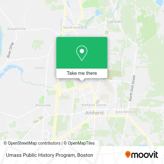
See Umass Public History Program, Boston, on the map
Public Transit to Umass Public History Program in Boston
Wondering how to get to Umass Public History Program in Boston? Moovit helps you find the best way to get to Umass Public History Program with step-by-step directions from the nearest public transit station.
Moovit provides free maps and live directions to help you navigate through your city. View schedules, routes, timetables, and find out how long does it take to get to Umass Public History Program in real time.
Looking for the nearest stop or station to Umass Public History Program? Check out this list of stops closest to your destination: Physical Sciences Building; Studio Arts Building; Green Lot 34; University Of Massachusetts Amherst; Haigis Mall.
Bus: B43, GREYHOUND US0256S, PETER PAN, 46, 30, 31, 33, 45, 38NS, B79.
Want to see if there’s another route that gets you there at an earlier time? Moovit helps you find alternative routes or times. Get directions from and directions to Umass Public History Program easily from the Moovit App or Website.
We make riding to Umass Public History Program easy, which is why over 1.7 million users, including users in Boston, trust Moovit as the best app for public transit. You don’t need to download an individual bus app or train app, Moovit is your all-in-one transit app that helps you find the best bus time or train time available.
For information on prices of bus, costs and ride fares to Umass Public History Program, please check the Moovit app.
Use the app to navigate to popular places including to the airport, hospital, stadium, grocery store, mall, coffee shop, school, college, and university.
Umass Public History Program Address: 161 Presidents Dr street in Boston
- Herter Hall,
- Herter Annex,
- Class Of 1954 Garden,
- Bezanson Recital Hall,
- Hicks,
- Rand Theater,
- Hicks Hall,
- Munson Hall,
- Fine Arts Center Plaza,
- Memorial Hall,
- Isle Of View,
- Bartlett Hall,
- Earthfoods,
- Whitmore Administration Building,
- People's Market,
- Isb Cafe,
- Whitmore Café,
- Tobin Hall,
- Minuteman Statue,
- Garber Field
Places Near Umass Public History Program (Boston)
- Boston Children's Hospital, Boston,
- North End, Boston,
- Cheers, Boston,
- Wang Theater, Boston,
- Boston Convention & Exhibition Center, Boston,
- Museum Of Science, Boston,
- Mgm Music Hall, Boston,
- House Of Blues, Boston,
- Boston Medical Center, Boston,
- Wilbur Theatre, Boston,
- Boston Common, Boston,
- Leader Bank Pavilion (Leader Bank Pavillion), Boston,
- Massachusetts General Hospital, Boston,
- Prudential Center, Boston,
- Castle Island, Boston,
- Td Garden, Boston,
- Faneuil Hall, Boston,
- Isabella Stewart Gardner Museum, Boston,
- Seaport District, Boston,
- Quincy Market, Boston
How to get to popular places in Boston with public transit
Get around Boston by public transit!
Traveling around Boston has never been so easy. See step by step directions as you travel to any attraction, street or major public transit station. View bus and train schedules, arrival times, service alerts and detailed routes on a map, so you know exactly how to get to anywhere in Boston.
When traveling to any destination around Boston use Moovit's Live Directions with Get Off Notifications to know exactly where and how far to walk, how long to wait for your line, and how many stops are left. Moovit will alert you when it's time to get off — no need to constantly re-check whether yours is the next stop.
Wondering how to use public transit in Boston or how to pay for public transit in Boston? Moovit public transit app can help you navigate your way with public transit easily, and at minimum cost. It includes public transit fees, ticket prices, and costs. Looking for a map of Boston public transit lines? Moovit public transit app shows all public transit maps in Boston with all Bus, Train, Subway and Ferry routes and stops on an interactive map.
Boston has 4 transit type(s), including: Bus, Train, Subway and Ferry, operated by several transit agencies, including MBTA, Southeastern Regional Transit Authority, MetroWest Regional Transit Authority, Rhode Island Public Transit Authority, WRTA, Lowell Regional Transit Authority, Merrimack Valley Transit, Montachusett Regional Transit Authority, Cape Cod Regional Transit Authority, Brockton Area Transit Authority, Martha's Vineyard Transit Authority, the WAVE - Nantucket Regional Transit Authority, GATRA, Cape Ann Transportation Authority and Massport
Public transit lines with stations closest to Umass Public History Program in Boston
Bus lines with stations closest to Umass Public History Program in Boston
Haigis Mall
- PETER PANAMHERST - NORTHAMPTON - BOSTON College Express
- PETER PANAMHERST - NORTHAMPTON - SPRINGFIELD - HARTFORD - NEW YORK Express Service
- PETER PANNEW YORK - HARTFORD - SPRINGFIELD - NORTHAMPTON - AMHERST Express Service
- PETER PANAMHERST - NORTHAMPTON - NEW YORK College Express
- B79Amherst-Worcester Intercity Service