Directions to Upper Manhattan with public transportation
The following transit lines have routes that pass near Upper Manhattan
Subway stations near Upper Manhattan
- 116 St, 1 min walk,
- 125 St, 8 min walk,
Bus stops near Upper Manhattan
- Adam C Powell Bl/W 125 St, 1 min walk,
- W 125 St/Adam C Powell Bl, 2 min walk,
- Malcolm X Bl/W 124 St, 5 min walk,
- Malcolm X Bl/W 125 St, 5 min walk,
Bus lines to Upper Manhattan
- M2, Washington Hts Bway-168 St Via Madison,
- M101, Ft George Via 3 Av Via Amsterdam Av,
- M125, The Hub 3 Av/149 St Via 125 St,
- M102, Lex Av-96 St Via Lenox Av,
- M7, 14 St Via Columbus Via 7 Av,
How to get to Upper Manhattan by bus?
Click on the bus route to see step by step directions with maps, line arrival times and updated time schedules.
How to get to Upper Manhattan by train?
Click on the train route to see step by step directions with maps, line arrival times and updated time schedules.
How to get to Upper Manhattan by subway?
Click on the subway route to see step by step directions with maps, line arrival times and updated time schedules.
What are the closest stations to Upper Manhattan?
The closest stations to Upper Manhattan are:
- 116 St is 63 yards away, 1 min walk.
- Adam C Powell Bl/W 125 St is 66 yards away, 1 min walk.
- W 125 St/Adam C Powell Bl is 105 yards away, 2 min walk.
- Malcolm X Bl/W 124 St is 338 yards away, 5 min walk.
- Malcolm X Bl/W 125 St is 359 yards away, 5 min walk.
- 125 St is 640 yards away, 8 min walk.
Which bus lines stop near Upper Manhattan?
These bus lines stop near Upper Manhattan: M125, M2, M60-SBS.
Which train lines stop near Upper Manhattan?
These train lines stop near Upper Manhattan: HARLEM, NEW HAVEN.
Which subway lines stop near Upper Manhattan?
These subway lines stop near Upper Manhattan: 2, 3, D.
What’s the nearest subway station to Upper Manhattan?
The nearest subway station to Upper Manhattan is 116 St. It’s a 1 min walk away.
What’s the nearest bus stop to Upper Manhattan?
The nearest bus stop to Upper Manhattan is Adam C Powell Bl/W 125 St. It’s a 1 min walk away.
What time is the first subway to Upper Manhattan?
The D is the first subway that goes to Upper Manhattan. It stops nearby at 3:03 AM.
What time is the last subway to Upper Manhattan?
The A is the last subway that goes to Upper Manhattan. It stops nearby at 4:07 AM.
What time is the first bus to Upper Manhattan?
The M60-SBS is the first bus that goes to Upper Manhattan. It stops nearby at 3:00 AM.
What time is the last bus to Upper Manhattan?
The M7 is the last bus that goes to Upper Manhattan. It stops nearby at 3:11 AM.
How much is the bus fare to Upper Manhattan?
The bus fare to Upper Manhattan costs about $2.75.
How much is the subway fare to Upper Manhattan?
The subway fare to Upper Manhattan costs about $2.75.
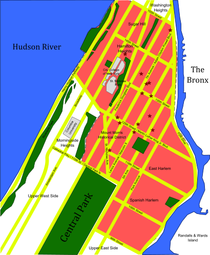
See Upper Manhattan on the map
Public Transportation to Upper Manhattan
Wondering how to get to Upper Manhattan, United States? Moovit helps you find the best way to get to Upper Manhattan with step-by-step directions from the nearest public transit station.
Moovit provides free maps and live directions to help you navigate through your city. View schedules, routes, timetables, and find out how long does it take to get to Upper Manhattan in real time.
Looking for the nearest stop or station to Upper Manhattan? Check out this list of stops closest to your destination: 116 St; Adam C Powell Bl/W 125 St; W 125 St/Adam C Powell Bl; Malcolm X Bl/W 124 St; Malcolm X Bl/W 125 St; 125 St.
Bus: M125, M2, M60-SBS, M101, M102.Train: HARLEM, NEW HAVEN.Subway: 2, 3, D, A, B, C.
Want to see if there’s another route that gets you there at an earlier time? Moovit helps you find alternative routes or times. Get directions from and directions to Upper Manhattan easily from the Moovit App or Website.
We make riding to Upper Manhattan easy, which is why over 1.5 million users, including users in Manhattan, trust Moovit as the best app for public transit. You don’t need to download an individual bus app or train app, Moovit is your all-in-one transit app that helps you find the best bus time or train time available.
For information on prices of subway, bus and train, costs and ride fares to Upper Manhattan, please check the Moovit app.
Use the app to navigate to popular places including to the airport, hospital, stadium, grocery store, mall, coffee shop, school, college, and university.
Location: Manhattan, New York - New Jersey
Attractions near Upper Manhattan
How to get to popular places in New York - New Jersey with public transit
Get around Manhattan by public transit!
Traveling around Manhattan has never been so easy. See step by step directions as you travel to any attraction, street or major public transit station. View bus and train schedules, arrival times, service alerts and detailed routes on a map, so you know exactly how to get to anywhere in Manhattan.
When traveling to any destination around Manhattan use Moovit's Live Directions with Get Off Notifications to know exactly where and how far to walk, how long to wait for your line, and how many stops are left. Moovit will alert you when it's time to get off — no need to constantly re-check whether yours is the next stop.
Wondering how to use public transit in Manhattan or how to pay for public transit in Manhattan? Moovit public transit app can help you navigate your way with public transit easily, and at minimum cost. It includes public transit fees, ticket prices, and costs. Looking for a map of Manhattan public transit lines? Moovit public transit app shows all public transit maps in Manhattan with all subway, bus or train routes and stops on an interactive map.
Manhattan has 3 transit type(s), including: subway, bus or train, operated by several transit agencies, including MTA Subway, Metro-North Railroad, LIRR, PATH, Shore Line East, MTA Bus Company, MTA New York City Transit - Express routes, MTA Bus, NJ Transit, NYC Ferry, NICE bus, Bee-Line Bus, NJ Transit Rail, NJ Transit Rail and Norwalk Transit District