Vigna Murata/Ruins stop - Monday schedule
| Line | Direction | Time |
|---|---|---|
| 765 | Arco Di Travertino (Metro A) | 5:08 AM |
| 702 | Torre Sant'Anastasia | 5:34 AM |
| 765 | Arco Di Travertino (Metro A) | 5:35 AM |
| 720 | Laurentina (Metro B) | 5:35 AM |
| 765 | Arco Di Travertino (Metro A) | 5:55 AM |
| 720 | Laurentina (Metro B) | 5:55 AM |
| 702 | Torre Sant'Anastasia | 6:04 AM |
| 765 | Arco Di Travertino (Metro A) | 6:15 AM |
| 720 | Laurentina (Metro B) | 6:16 AM |
| 721 | Castello Della Cecchignola | 6:28 AM |
| 702 | Torre Sant'Anastasia | 6:29 AM |
| 765 | Arco Di Travertino (Metro A) | 6:34 AM |
| 720 | Laurentina (Metro B) | 6:36 AM |
| 765 | Arco Di Travertino (Metro A) | 6:46 AM |
| 721 | Castello Della Cecchignola | 6:48 AM |
| 702 | Torre Sant'Anastasia | 6:54 AM |
| 765 | Arco Di Travertino (Metro A) | 6:55 AM |
| 720 | Laurentina (Metro B) | 6:56 AM |
| 721 | Castello Della Cecchignola | 7:08 AM |
| 720 | Laurentina (Metro B) | 7:14 AM |
| 765 | Arco Di Travertino (Metro A) | 7:14 AM |
| 702 | Torre Sant'Anastasia | 7:22 AM |
| 765 | Arco Di Travertino (Metro A) | 7:24 AM |
| 720 | Laurentina (Metro B) | 7:32 AM |
| 765 | Arco Di Travertino (Metro A) | 7:34 AM |
Directions to Vigna Murata/Ruins stop (Roma) with public transit
The following transit lines have routes that pass near Vigna Murata/Ruins
 Bus: 702, 720, 721, 762, 765.
- Metro: B.
How to get to Vigna Murata/Ruins stop by bus?
Click on the bus route to see step by step directions with maps, line arrival times and updated time schedules.
How to get to Vigna Murata/Ruins stop by metro?
Click on the metro route to see step by step directions with maps, line arrival times and updated time schedules.
Bus stops near Vigna Murata/Ruins stop in Roma
- Vigna Murata/Ruins, 2 min walk,
- Vigna Murata/Gradi, 4 min walk,
Metro stations near Vigna Murata/Ruins station in Roma
- Laurentina, 27 min walk,
Bus lines to Vigna Murata/Ruins stop in Roma
- 720, Circolare | Laurentina (MB) - Ciampino Aeroporto - Laurentina (MB),
- 765, Arco di Travertino (MA) - Laurentina (MB),
- 702, Laurentina (MB) - Divino Amore - Borgo Lotti,
- 721, Circolare | Castello della Cecchignola - Laurentina (MB) - Castello della Cecchignola,
- 762, Agriculture,
- 772, Eur Fermi (Metro B),
What are the closest stations to Vigna Murata/Ruins?
The closest stations to Vigna Murata/Ruins are:
- Vigna Murata/Ruins stop is 91 meters away, 2 min walk.
- Vigna Murata/Gradi stop is 264 meters away, 4 min walk.
- Laurentina station is 2063 meters away, 27 min walk.
Which bus lines stop near Vigna Murata/Ruins?
These bus lines stop near Vigna Murata/Ruins: 702, 720, 721, 762, 765.
Which metro line stops near Vigna Murata/Ruins?
B (Laurentina)
What’s the nearest metro station to Vigna Murata/Ruins in Roma?
The nearest metro station to Vigna Murata/Ruins in Roma is Laurentina. It’s a 27 min walk away.
What’s the nearest bus station to Vigna Murata/Ruins in Roma?
The nearest bus station to Vigna Murata/Ruins in Roma is Vigna Murata/Ruins. It’s a 2 min walk away.
What time is the first metro to Vigna Murata/Ruins in Roma?
The B is the first metro that goes to Vigna Murata/Ruins in Roma. It stops nearby at 5:30 AM.
What time is the last metro to Vigna Murata/Ruins in Roma?
The B is the last metro that goes to Vigna Murata/Ruins in Roma. It stops nearby at 12:09 AM.
What time is the first bus to Vigna Murata/Ruins in Roma?
The 702 is the first bus that goes to Vigna Murata/Ruins in Roma. It stops nearby at 5:33 AM.
What time is the last bus to Vigna Murata/Ruins in Roma?
The 721 is the last bus that goes to Vigna Murata/Ruins in Roma. It stops nearby at 12:43 AM.
Vigna Murata/Ruins station
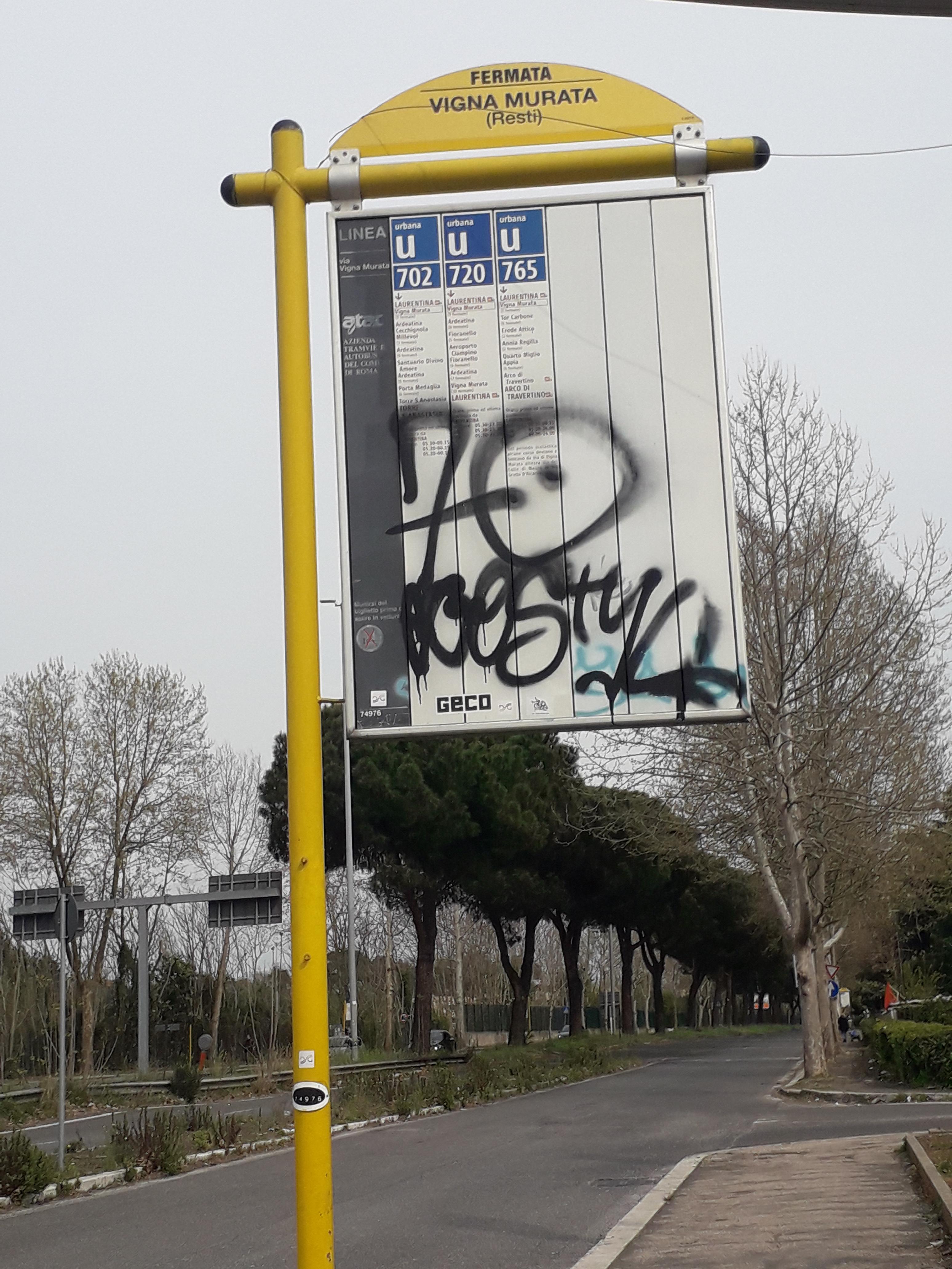 Taken by Monica i.
See Vigna Murata/Ruins stop, Roma, on the map
Public transit to Vigna Murata/Ruins stop (ID: 74976) in Roma
Looking for directions to Vigna Murata/Ruins in Roma, Italy?
Download the Moovit App to find the current schedule and step-by-step directions for Bus or Metro routes that pass through Vigna Murata/Ruins.
Looking for the nearest stops closest to Vigna Murata/Ruins ? Check out this list of closest stops to your destination: Vigna Murata/Ruins; Vigna Murata/Gradi; Laurentina.
Bus: 702, 720, 721, 762, 765, 772.Metro: B.
We make riding on public transit to Vigna Murata/Ruins easy, which is why over 1.7 billion users, including users in Roma trust Moovit as the best app for public transit.
Use the app to navigate to popular places including to the airport, hospital, stadium, grocery store, mall, coffee shop, school, college, and university.
Vigna Murata/Ruins stop’s code is 74976
The first line to this stop is 765, at 5:08 AM, and the last line is 721 at 12:24 AM.
This stop serves Troiani Transportation Services and ATAC’s lines
- Vigna Murata/Ruins,
- Vigna Murata/Gradi
Bus stops near Vigna Murata/Ruins stop
- Laurentina
Metro station near Vigna Murata/Ruins station
- Travertine Arch/Tuscolana,
- Campo Boario,
- Parioli/Oxilia,
- Ladispoli, Odescalchi Road, 139,
- Civita Castellana - Magliano,
- Nuovo Salario,
- Cerveteri | Marina Di Cerveteri Station,
- Terracina | Lido Delle Ortensie,
- Ballarin,
- Marino | San Giuseppe Hospital,
- Bracciano Hospital,
- Corso/Minghetti,
- America/Tolstoi,
- Verano,
- Civita - Pian Paradiso,
- Flaminia/Tor Di Quinto,
- Sabaudia | Pontina Street 54th Mile,
- Lungotevere Farnesina/Trilussa,
- Vigna Clara,
- Roma Nomentana
Popular public transit stations in Roma
Get around Roma by public transit!
Traveling around Roma has never been so easy. See step by step directions as you travel to any attraction, street or major public transit station. View bus and train schedules, arrival times, service alerts and detailed routes on a map, so you know exactly how to get to anywhere in Roma.
When traveling to any destination around Roma use Moovit's Live Directions with Get Off Notifications to know exactly where and how far to walk, how long to wait for your line, and how many stops are left. Moovit will alert you when it's time to get off — no need to constantly re-check whether yours is the next stop.
Wondering how to use public transit in Roma or how to pay for public transit in Roma? Moovit public transit app can help you navigate your way with public transit easily, and at minimum cost. It includes public transit fees, ticket prices, and costs. Looking for a map of Roma public transit lines? Moovit public transit app shows all public transit maps in Roma with all Bus, Train, Metro, Light Rail, Ferry, Funicular and Gondola routes and stops on an interactive map.
Rome and Lazio has 7 transit type(s), including: Bus, Train, Metro, Light Rail, Ferry, Funicular and Gondola, operated by several transit agencies, including ATAC, Cotral, Trenitalia, Troiani Transportation Services, BIS, ATR Mobility, Tuscia, Shuttle, Seatour, Troiani Bus Lines, CSC Mobility, Terravision, ATRAL, Tambus and Sitbus