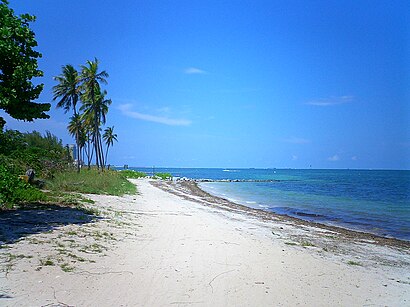
Directions to Virginia Key Beach (Key Biscayne) with public transportation
The following transit lines have routes that pass near Virginia Key Beach
How to get to Virginia Key Beach by bus?
Click on the bus route to see step by step directions with maps, line arrival times and updated time schedules.
Bus stops near Virginia Key Beach in Key Biscayne
- Rickenbacker Cswy & Virginia Bch Dr, 19 min walk,
Bus lines to Virginia Key Beach in Key Biscayne
- 26, 26 - Key Biscayne,
What are the closest stations to Virginia Key Beach?
The closest stations to Virginia Key Beach are:
- Rickenbacker Cswy & Virginia Bch Dr is 1561 yards away, 19 min walk.
Which bus line stops near Virginia Key Beach?
102
See Virginia Key Beach, Key Biscayne, on the map
Public Transit to Virginia Key Beach in Key Biscayne
Wondering how to get to Virginia Key Beach in Key Biscayne, United States? Moovit helps you find the best way to get to Virginia Key Beach with step-by-step directions from the nearest public transit station.
Moovit provides free maps and live directions to help you navigate through your city. View schedules, routes, timetables, and find out how long does it take to get to Virginia Key Beach in real time.
Looking for the nearest stop or station to Virginia Key Beach? Check out this list of stops closest to your destination: Rickenbacker Cswy & Virginia Bch Dr.
Bus: 102, 26.
Want to see if there’s another route that gets you there at an earlier time? Moovit helps you find alternative routes or times. Get directions from and directions to Virginia Key Beach easily from the Moovit App or Website.
We make riding to Virginia Key Beach easy, which is why over 1.5 million users, including users in Key Biscayne, trust Moovit as the best app for public transit. You don’t need to download an individual bus app or train app, Moovit is your all-in-one transit app that helps you find the best bus time or train time available.
For information on prices of bus and subway, costs and ride fares to Virginia Key Beach, please check the Moovit app.
Use the app to navigate to popular places including to the airport, hospital, stadium, grocery store, mall, coffee shop, school, college, and university.
Location: Key Biscayne, Miami
Attractions near Virginia Key Beach
Arthur Lamb Junior Road,Virginia Beach,1,Cayo Ratones,Duck Lake,Historic Virginia Key Beach Park,Virginia Key,WKAT-AM (North Miami),WQAM-AM (Miami),Virginia Key,Virginia Key Beach Park,Virginia Beach County Park,Virginia Beach,Virginia Beach (Virginia Key),Virginia Key,Central Wastewater Plant,Historic Virginia Key Beach Park,Virginia Key Park,1,Dartmouth InletHow to get to popular attractions in Key Biscayne with public transit
Palm Beach Gardens, Jupiter,Walmart Supercenter, Deerfield Beach,Flanigan's Seafood Bar & Grill, North Westside,Bougainvillea's Old Florida Tavern, Miami,Novecento, Miami,Bru's Room Sports Grill - Coconut Creek, Deerfield Beach,Fresh Market, Miami,Seminole Casino Coconut Creek, Deerfield Beach,Carpaccio, Miami Beach,Costco Wholesale, Boca Raton,Whole Foods Market, Boca Raton,LIV Miami, Miami Beach,Miller's Ale House - Miami Doral, North Westside,The Cheesecake Factory, North Westside,Walmart Supercenter, Plantation,Lauderdale-By-The-Sea Beach, Fort Lauderdale,Boynton Beach, FL, Boynton Beach-Delray Beach,Flanigan's Seafood Bar & Grill, Kendale Lakes-Tamiami,Kravis Center for the Performing Arts, Inc., West Palm Beach,BB&T Center, PlantationGet around Miami by public transit!
Traveling around Miami has never been so easy. See step by step directions as you travel to any attraction, street or major public transit station. View bus and train schedules, arrival times, service alerts and detailed routes on a map, so you know exactly how to get to anywhere in Miami.
When traveling to any destination around Miami use Moovit's Live Directions with Get Off Notifications to know exactly where and how far to walk, how long to wait for your line, and how many stops are left. Moovit will alert you when it's time to get off — no need to constantly re-check whether yours is the next stop.
Wondering how to use public transit in Miami or how to pay for public transit in Miami? Moovit public transit app can help you navigate your way with public transit easily, and at minimum cost. It includes public transit fees, ticket prices, and costs. Looking for a map of Miami public transit lines? Moovit public transit app shows all public transit maps in Miami with all Bus, Train, Subway, Light Rail and Ferry routes and stops on an interactive map.
Miami has 5 transit type(s), including: Bus, Train, Subway, Light Rail and Ferry, operated by several transit agencies, including Miami-Dade Transit, Miami Dade Transit-Rail, Tri-Rail, Broward County Transit, Palm Tran, Brightline, MARTY, City of Homestead Trolley, Key West Transit, Treasure Coast Connector, GoLine IRT, Amtrak, Greyhound-us, Megabus, FlixBus-us