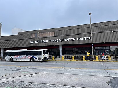
Directions to Walter Rand Transportation Center (Camden) with public transportation
The following transit lines have routes that pass near Walter Rand Transportation Center
How to get to Walter Rand Transportation Center by bus?
Click on the bus route to see step by step directions with maps, line arrival times and updated time schedules.
How to get to Walter Rand Transportation Center by metro?
Click on the metro route to see step by step directions with maps, line arrival times and updated time schedules.
Bus stops near Walter Rand Transportation Center in Camden
- Broadway Across From Wrtc, 2 min walk,
- Broadway In Front Of Wrtc, 7 min walk,
- Gate #5 Inside the Wrtc, 7 min walk,
- Camden Walter Rand Trans Center, 8 min walk,
Light Rail stations near Walter Rand Transportation Center in Camden
- Cooper Street/Rutgers Light Rail Station, 11 min walk,
Metro station near Walter Rand Transportation Center in Camden
- Broadway, 29 min walk,
Bus lines to Walter Rand Transportation Center in Camden
- 400, Philadelphia Gp Outlets,
- 401, Woodbury,
- 402, Pennsville,
- 406, Philadelphia,
- 410, Mullica Hill,
- 412, Glassboro Holly Dell,
- 450, Cherry Hill Mall,
- 452, Cramer Hill Kroc Ctr,
- 453, Camden Riverside Dr,
- 457, Moorestown Mall Via Gaither Drive,
- 313, Philadelphia 30th Street,
- 315, Wildwood Rio Grande Cape May,
- 317, Asbury Park,
- 403, Turnersville Cros Keys Com,
- 404, Philadelphia,
- 407, Moorestown Mall,
- 408, Philadelphia,
- 409, Trenton Via Wrtc,
- 413, Florence,
- 418, Camden Exp Willingboro Camden Exp Malls,
What are the closest stations to Walter Rand Transportation Center?
The closest stations to Walter Rand Transportation Center are:
- Broadway Across From Wrtc is 116 yards away, 2 min walk.
- Broadway In Front Of Wrtc is 513 yards away, 7 min walk.
- Gate #5 Inside the Wrtc is 566 yards away, 7 min walk.
- Camden Walter Rand Trans Center is 574 yards away, 8 min walk.
- Cooper Street/Rutgers Light Rail Station is 897 yards away, 11 min walk.
- Broadway is 2416 yards away, 29 min walk.
Which bus lines stop near Walter Rand Transportation Center?
These bus lines stop near Walter Rand Transportation Center: 315, 400, 406, 408, 419.
Which metro line stops near Walter Rand Transportation Center?
PATCO (Lindenwold)
Which light rail line stops near Walter Rand Transportation Center?
RVLN (Rvln Waterfront Enter Center)
What’s the nearest light rail station to Walter Rand Transportation Center in Camden?
The nearest light rail station to Walter Rand Transportation Center in Camden is Cooper Street/Rutgers Light Rail Station. It’s a 11 min walk away.
What’s the nearest metro station to Walter Rand Transportation Center in Camden?
The nearest metro station to Walter Rand Transportation Center in Camden is Broadway. It’s a 29 min walk away.
What’s the nearest bus station to Walter Rand Transportation Center in Camden?
The nearest bus station to Walter Rand Transportation Center in Camden is Broadway Across From Wrtc. It’s a 2 min walk away.
What time is the first bus to Walter Rand Transportation Center in Camden?
The 551 is the first bus that goes to Walter Rand Transportation Center in Camden. It stops nearby at 3:52 AM.
What time is the last bus to Walter Rand Transportation Center in Camden?
The 551 is the last bus that goes to Walter Rand Transportation Center in Camden. It stops nearby at 3:52 AM.
See Walter Rand Transportation Center, Camden, on the map
Public Transit to Walter Rand Transportation Center in Camden
Wondering how to get to Walter Rand Transportation Center in Camden, United States? Moovit helps you find the best way to get to Walter Rand Transportation Center with step-by-step directions from the nearest public transit station.
Moovit provides free maps and live directions to help you navigate through your city. View schedules, routes, timetables, and find out how long does it take to get to Walter Rand Transportation Center in real time.
Looking for the nearest stop or station to Walter Rand Transportation Center? Check out this list of stops closest to your destination: Broadway Across From Wrtc; Broadway In Front Of Wrtc; Gate #5 Inside the Wrtc; Camden Walter Rand Trans Center; Cooper Street/Rutgers Light Rail Station; Broadway.
Bus: 315, 400, 406, 408, 419, 401, 402, 410, 313, 317, 403, 404, 405, GREYHOUND US0305, GREYHOUND US0421.Metro: PATCO.Light Rail: RVLN.
Want to see if there’s another route that gets you there at an earlier time? Moovit helps you find alternative routes or times. Get directions from and directions to Walter Rand Transportation Center easily from the Moovit App or Website.
We make riding to Walter Rand Transportation Center easy, which is why over 1.5 million users, including users in Camden, trust Moovit as the best app for public transit. You don’t need to download an individual bus app or train app, Moovit is your all-in-one transit app that helps you find the best bus time or train time available.
For information on prices of metro, bus and light rail, costs and ride fares to Walter Rand Transportation Center, please check the Moovit app.
Use the app to navigate to popular places including to the airport, hospital, stadium, grocery store, mall, coffee shop, school, college, and university.
Walter Rand Transportation Center Address: Hudson Street street in Camden
Places Near Walter Rand Transportation Center (Camden)
How to get to popular places in Philadelphia with public transit
Get around Camden by public transit!
Traveling around Camden has never been so easy. See step by step directions as you travel to any attraction, street or major public transit station. View bus and train schedules, arrival times, service alerts and detailed routes on a map, so you know exactly how to get to anywhere in Camden.
When traveling to any destination around Camden use Moovit's Live Directions with Get Off Notifications to know exactly where and how far to walk, how long to wait for your line, and how many stops are left. Moovit will alert you when it's time to get off — no need to constantly re-check whether yours is the next stop.
Wondering how to use public transit in Camden or how to pay for public transit in Camden? Moovit public transit app can help you navigate your way with public transit easily, and at minimum cost. It includes public transit fees, ticket prices, and costs. Looking for a map of Camden public transit lines? Moovit public transit app shows all public transit maps in Camden with all Bus, Train, Metro, Light Rail and Cable Car routes and stops on an interactive map.
Philadelphia has 5 transit type(s), including: Bus, Train, Metro, Light Rail and Cable Car, operated by several transit agencies, including SEPTA Subway, SEPTA Rail, SEPTA, NJ Transit Rail, NJ Transit Bus, Port Authority Transit Corporation, Navy Yard, Penn Transit, Drexel University, Pottstown Area Rapid Transit (PART), Fullington Tours, Chescobus, Amtrak, Greyhound-us and FlixBus-us