See Wardman Row, Washington, on the map
Transferred from en.wikipedia
Directions to Wardman Row (Washington) with public transportation
The following transit lines have routes that pass near Wardman Row
 Bus:
Bus: - Train:
- Metro:
How to get to Wardman Row by bus?
Click on the bus route to see step by step directions with maps, line arrival times and updated time schedules.
How to get to Wardman Row by train?
Click on the train route to see step by step directions with maps, line arrival times and updated time schedules.
How to get to Wardman Row by metro?
Click on the metro route to see step by step directions with maps, line arrival times and updated time schedules.
Bus stations near Wardman Row in Washington
- P St & 16th St,9 min walk,
Bus lines to Wardman Row in Washington
- G2,East To Ledroit Park-Howard University,
What are the closest stations to Wardman Row?
The closest stations to Wardman Row are:
- P St & 16th St is 702 yards away, 9 min walk.
Which bus lines stop near Wardman Row?
These bus lines stop near Wardman Row: 52, 54, S2.
Which train line stops near Wardman Row?
FREDERICKSBURG LINE
Which metro lines stop near Wardman Row?
These metro lines stop near Wardman Row: METRORAIL GREEN LINE, METRORAIL SILVER LINE.
What’s the nearest bus stop to Wardman Row in Washington?
The nearest bus stop to Wardman Row in Washington is P St & 16th St. It’s a 9 min walk away.
See Wardman Row, Washington, on the map
Transferred from en.wikipedia
Public Transit to Wardman Row in Washington
Wondering how to get to Wardman Row in Washington, United States? Moovit helps you find the best way to get to Wardman Row with step-by-step directions from the nearest public transit station.
Moovit provides free maps and live directions to help you navigate through your city. View schedules, routes, timetables, and find out how long does it take to get to Wardman Row in real time.
Looking for the nearest stop or station to Wardman Row? Check out this list of stops closest to your destination: P St & 16th St.
Bus:Train:Metro:
Want to see if there’s another route that gets you there at an earlier time? Moovit helps you find alternative routes or times. Get directions from and directions to Wardman Row easily from the Moovit App or Website.
We make riding to Wardman Row easy, which is why over 1.5 million users, including users in Washington, trust Moovit as the best app for public transit. You don’t need to download an individual bus app or train app, Moovit is your all-in-one transit app that helps you find the best bus time or train time available.
For information on prices of bus, metro and train, costs and ride fares to Wardman Row, please check the Moovit app.
Use the app to navigate to popular places including to the airport, hospital, stadium, grocery store, mall, coffee shop, school, college, and university.
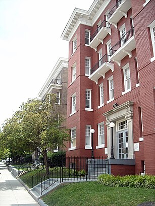
Wardman Row Address: R Street Northwest street in Washington
Transferred from en.wikipedia
Attractions near Wardman Row
Wardman Row Building,1707 Johnson Ave NW ,Gladstone and Hawarden Apartment Buildings,14th & Corcoran,1700 14th St NW ,Leory Dixon Enterprises,Court Reporters,Planet Pet,7 Days Emergency 1 Locksmith,Brian Diener Jewelers,Law Office of Rodney Jones,Law Office of John Perazich,Champion-Kail Travel Group,Gih,All Junk Trash Removal Cleaning & Demolition,The Washington Blade,Michael Wipranik & Daniel Booth,Guest and Co,Sette Osteria - Logan Circle,BodysmithHow to get to popular attractions in Washington with public transit
I-95 Exit 158: Prince William Pkwy, Prince William County,Sweetwater Tavern, Fairfax County,O'Sullivan's Irish Pub & Restaurant, Arlington County,Toki Underground, Washington,AMC Owings Mills 17, Baltimore County,Biergarten Haus, Washington,Teaism Penn Quarter, Washington,Arlington Rooftop Bar & Grill, Arlington County,Pearl Dive Oyster Palace, Washington,Baltimore Farmers' Market & Bazaar, Baltimore,Lost Society, Washington,Federal Center SW Metro Station, Washington,Urbana, Washington,Herndon, Virginia, Fairfax County,Anne Arundel Community College, Anne Arundel County,Miss Shirley's Cafe, Baltimore,Mt. Pleasant, Washington,Bar Louie, Washington,Hamilton's Bar & Grill, Washington,Dundalk, Maryland, Baltimore CountyGet around Washington by public transit!
Traveling around Washington has never been so easy. See step by step directions as you travel to any attraction, street or major public transit station. View bus and train schedules, arrival times, service alerts and detailed routes on a map, so you know exactly how to get to anywhere in Washington.
When traveling to any destination around Washington use Moovit's Live Directions with Get Off Notifications to know exactly where and how far to walk, how long to wait for your line, and how many stops are left. Moovit will alert you when it's time to get off — no need to constantly re-check whether yours is the next stop.
Wondering how to use public transit in Washington or how to pay for public transit in Washington? Moovit public transit app can help you navigate your way with public transit easily, and at minimum cost. It includes public transit fees, ticket prices, and costs. Looking for a map of Washington public transit lines? Moovit public transit app shows all public transit maps in Washington with all bus, metro or train routes and stops on an interactive map.
Washington has 3 transit type(s), including: bus, metro or train, operated by several transit agencies, including WMATA, WMATA, Montgomery County Ride On, Fairfax Connector, TheBus, DC Circulator, MDOT MTA, Marc, MDOT MTA, MDOT MTA, Virginia Railway Express (VRE), PRTC, DASH - Alexandria, Arlington Transit (ART) and DC Streetcar