Directions to Wonder Lake State Park (Patterson, Ny) with public transportation
The following transit lines have routes that pass near Wonder Lake State Park
Train stations near Wonder Lake State Park in Patterson, Ny
- Patterson,78 min walk,
What are the closest stations to Wonder Lake State Park?
The closest stations to Wonder Lake State Park are:
- Patterson is 6499 yards away, 78 min walk.
Which train line stops near Wonder Lake State Park?
HARLEM
See Wonder Lake State Park, Patterson, Ny, on the map
Public Transit to Wonder Lake State Park in Patterson, Ny
Wondering how to get to Wonder Lake State Park in Patterson, Ny, United States? Moovit helps you find the best way to get to Wonder Lake State Park with step-by-step directions from the nearest public transit station.
Moovit provides free maps and live directions to help you navigate through your city. View schedules, routes, timetables, and find out how long does it take to get to Wonder Lake State Park in real time.
Looking for the nearest stop or station to Wonder Lake State Park? Check out this list of stops closest to your destination: Patterson.
Train:HARLEMWASSAIC
Want to see if there’s another route that gets you there at an earlier time? Moovit helps you find alternative routes or times. Get directions from and directions to Wonder Lake State Park easily from the Moovit App or Website.
We make riding to Wonder Lake State Park easy, which is why over 1.5 million users, including users in Patterson, Ny, trust Moovit as the best app for public transit. You don’t need to download an individual bus app or train app, Moovit is your all-in-one transit app that helps you find the best bus time or train time available.
For information on prices of train and bus, costs and ride fares to Wonder Lake State Park, please check the Moovit app.
Use the app to navigate to popular places including to the airport, hospital, stadium, grocery store, mall, coffee shop, school, college, and university.
Location: Patterson, Ny, New York - New Jersey
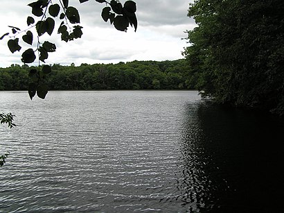
Wonder Lake State Park is a 1,145-acre (4.6 km2) state park in Putnam County, in the U.S. state of New York, in the Town of Patterson.Wiki
Attractions near Wonder Lake State Park
Wonder Lake,Wonder Lake,Iron Hill,238 Ludingtonville Rd,180 Ludingtonville Rd,171 Ludingtonville Rd,141 Ludingtonville Rd,Metric Motors,U-Haul Co,Maynard Corners,Resource Center The,Anthony's Appliance,Creative Kids Kent,Kollevoll Realty Co,Putnam Benefits & Insurance,Freeway 84,Bare Hill,1,Bear Hill,U S Tank TechHow to get to popular attractions in Patterson, Ny with public transit
Rubirosa Ristorante, Manhattan,Tacombi at Fonda Nolita, Manhattan,Roberta's Pizza,Stout, Manhattan,Virgin America Ticket Counter, Elizabeth, Nj,MTA Subway - 30th Ave (N/W), Queens,Caesars Atlantic City Hotel and Casino, Atlantic City, Nj,Hotel Chantelle, Manhattan,Gramercy Tavern, Manhattan,Nan Xiang Xiao Long Bao, Queens,Gyu-Kaku Japanese BBQ, Manhattan,Newark Liberty International Airport (EWR), Newark, Nj,The Plaza Hotel, Manhattan,SoHo, Manhattan,Jing Fong Restaurant 金豐大酒樓, Manhattan,Harrah's Resort Hotel & Casino, Atlantic City, Nj,Peter Luger Steak House,Brass Monkey, Manhattan,Bill's Bar & Burger, Manhattan,Sheep Meadow, ManhattanGet around Patterson, Ny by public transit!
Traveling around Patterson, Ny has never been so easy. See step by step directions as you travel to any attraction, street or major public transit station. View bus and train schedules, arrival times, service alerts and detailed routes on a map, so you know exactly how to get to anywhere in Patterson, Ny.
When traveling to any destination around Patterson, Ny use Moovit's Live Directions with Get Off Notifications to know exactly where and how far to walk, how long to wait for your line, and how many stops are left. Moovit will alert you when it's time to get off — no need to constantly re-check whether yours is the next stop.
Wondering how to use public transit in Patterson, Ny or how to pay for public transit in Patterson, Ny? Moovit public transit app can help you navigate your way with public transit easily, and at minimum cost. It includes public transit fees, ticket prices, and costs. Looking for a map of Patterson, Ny public transit lines? Moovit public transit app shows all public transit maps in Patterson, Ny with all train or bus routes and stops on an interactive map.
Patterson, Ny has 2 transit type(s), including: train or bus, operated by several transit agencies, including MTA Subway, Metro-North Railroad, LIRR, PATH, Shore Line East, MTA Bus Company, MTA New York City Transit - Express routes, MTA Bus, NJ Transit, NYC Ferry, NICE bus, Bee-Line Bus, NJ Transit Rail, NJ Transit Rail and Norwalk Transit District