
17 Bus Route Map
View the 17 route map and see all 17 stops along the route. The map of 17 shows where the bus travels and the location of each stop, making it easy to understand the entire route at a glance.
Explore Electra Afikim routes on the map and see where Electra Afikim bus services operate. Use the 17 map to find bus stops and see how the 17 connects different areas along its trip.
All 17 stops on the map are displayed in route order, helping you follow the 17 bus from the first stop to the last.
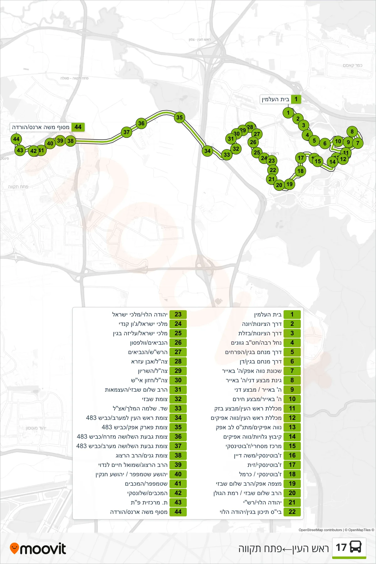
Stops list (17 - Rosh HaAyin→Petah Tikva)
- Cemetery
- Derech HaTziyonut/Yona
- Hatzionut Road/Bazelet
- Nachal Raba/Gvanim Middle School
- Menachem Begin Road/HaPrachim
- Menachem Begin Road/Dan
- Neve Afek Neighborhood/5th of Iyar
- Danny Operation Garden/5th of Iyar
- 5th of Iyar/Mivtza Danny
- 5th of Iyar/Mivtza Hiram
- Rosh HaAyin College/Mivtza Bazak
- Rosh HaAyin College/Neve Afikim
- Neve Afikim/Lev Afek Community Center
- Kibbutz Galuyot/Neve Afikim
- Shopping Center/Jabotinsky
- Jabotinsky/Moshe Dayan
- Jabotinsky/Zayit
- Jabotinsky/Carmel
- Mitzpe Afek/Rabbi Shalom Shabazi
- Rabbi Shalom Shabazi/Ramat HaGolan
- Yehuda HaLevi/Rashi
- Begin High School/Yehuda HaLevi
- Yehuda Halevi/Malchei Israel
- Malchei Israel/John Kennedy
- Malchei Israel/Aliza Begin
- HaNeviim/Wolfson
- HaRashash/HaNeviim
- Tzahal/Ibn Ezra
- IDF/HaShiryon
- IDF/Chazon Ish
- Rabbi Shalom Shabazi/Ha'atzmaut
- Shabazi Junction
- King Solomon Boulevard/Etzel
- Rosh HaAyin West Junction/Road 483
- Afek Park Junction/Road 483
- Givat HaShlosha East Junction/Road 483
- West Givat HaShlosha Junction/Road 483
- Ganim Junction/HaRav Herzog
- Rabbi Herzog/Shmuel Chaim Landau
- Yehoshua Stampfer/Yehoshua Hankin
- Stampfer/HaMaccabim
- HaMaccabim/Shlonsky
- Petah Tikva Central Station
- Moshe Arens Terminal/Drop Off